ಮಾಜುಲಿ
ಮಾಜುಲಿ ಅಥವಾ ಮಾಜೋಲಿ[೧] ಅಸ್ಸಾಂ ರಾಜ್ಯದಲ್ಲಿ ಬ್ರಹಪುತ್ರ ನದಿಯಲ್ಲಿರುವ ದ್ವೀಪವಾಗಿದೆ. ೨೦೧೬ರಲ್ಲಿ ಇದು ಒಂದು ಜಿಲ್ಲೆಯೆಂದು ಘೋಷಿತವಾದ ಮೊದಲ ದ್ವೀಪವಾಯಿತು.[೨] ೨೦ನೇ ಶತಮಾನದ ಆರಂಭದಲ್ಲಿ ಇದು ೮೮೦ ಚದರ ಕಿಲೋಮೀಟರ್ನಷ್ಟು ವಿಸ್ತೀರ್ಣವನ್ನು ಹೊಂದಿತ್ತು,[೩] ಆದರೆ ಕ್ಷರಣಕ್ಕೆ ಗಣನೀಯವಾಗಿ ಕಳೆದುಕೊಂಡು ೨೦೧೪ರ ವೇಳೆಗೆ ಇದು ೩೫೨ ಚದರ ಕಿಲೋಮೀಟರ್ಗಳಷ್ಟು ಆವರಿಸಿದೆ.[೪] ಅದರ ಸುತ್ತಲಿರುವ ನದಿ ಬೆಳೆದಂತೆ ಮಾಜುಲಿ ಸಂಕುಚಿಸಿದೆ.[೫] ಪ್ರಸಕ್ತವಾಗಿ ಮಾಜುಲಿ ಗಿನೆಸ್ ವಿಶ್ವ ದಾಖಲೆಗಳ ಪುಸ್ತಕದಲ್ಲಿ ವಿಶ್ವದ ಅತಿ ದೊಡ್ಡ ನದಿ ದ್ವೀಪವೆಂದು ಪಟ್ಟಿಮಾಡಲ್ಪಟ್ಟಿದೆ.[೬]

ಈ ದ್ವೀಪವು ದಕ್ಷಿಣದಲ್ಲಿ ಬ್ರಹ್ಮಪುತ್ರ ನದಿಯಿಂದ ಮತ್ತು ಉತ್ತರದಲ್ಲಿ ಸುಬನ್ಸಿರಿ ನದಿಯಿಂದ ಕೂಡಿಕೊಂಡು ಬ್ರಹ್ಮಪುತ್ರದ ಸಂಗಮಶಾಖೆಯಾದ ಖೇರ್ಕುಟಿಯಾ ಕ್ಷೂಟಿಯಿಂದ ರೂಪಗೊಂಡಿದೆ.[೭] ಜೋರ್ಹಾಟ್ ನಗರದಿಂದ ಫ಼ೆರಿಗಳ ಮೂಲಕ ಮಾಜುಲಿ ದ್ವೀಪವನ್ನು ತಲುಪಬಹುದು. ಬ್ರಹ್ಮಪುತ್ರ ನದಿ ಹಾಗೂ ಅದರ ಉಪನದಿಗಳ ಮಾರ್ಗ ಬದಲಾವಣೆಗಳ ಕಾರಣದಿಂದ ಇದು ರೂಪಗೊಂಡಿತು. ಮಾಜುಲಿ ಅಸ್ಸಾಮೀ ನವ ವೈಷ್ಣವ ಸಂಸ್ಕೃತಿಯ ವಾಸಸ್ಥಾನವಾಗಿದೆ.
ಛಾಯಾಂಕಣ
ಬದಲಾಯಿಸಿ-
 ಕಮಲಾಬಾರಿ ಸತ್ರ
 -
 ದಖಿನ್ಪತ್ ಸತ್ರ
 -
 ದಖಿನ್ಪತ್ ಸತ್ರದಲ್ಲಿ ಪೂಜೆ
 -
 ಒಂದು ಸತ್ರದಿಂದ
 -
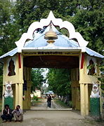 ಔನಿಯಾತಿ ಸತ್ರದ ಪ್ರವೇಶದ್ವಾರ
 -
 ಕಮಲಾಬಾರಿ ಅಂಚೆ ಕಚೇರಿ


.jpg)
ಉಲ್ಲೇಖಗಳು
ಬದಲಾಯಿಸಿ- ↑ Official Website
- ↑ Majuli, District (8 September 2016). "World's largest river island, Majuli, becomes India's first island district". FP India. Retrieved 13 September 2016.
- ↑ Sarma, J. N.; Phukan, M. K. (3 May 2004). "Origin and some geomorphological changes of Majuli Island of the Brahmaputra River in Assam, India". Geomorphology. 60 (1–2): 1–19. Bibcode:2004Geomo..60....1S. doi:10.1016/j.geomorph.2003.07.013.
- ↑ Manogya Loiwal (18 February 2014). "Majuli, world's largest river island is shrinking and sinking". India Today. Retrieved 5 April 2016.
- ↑ Yardley, Jim (14 April 2013). "A Capricious River, an Indian Island's Lifeline, Now Eats Away at It". The New York Times. Majuli, India.
- ↑ "Largest river island". www.guinnessworldrecords.com. Guinness World Records. Retrieved September 9, 2020.
- ↑ "Majuli is declared the largest river island in world by Guinness World Records: 10 facts about it". India Today. 3 September 2016. Retrieved 9 September 2020.
- Nagchoudhury, Subrata (28 February 1997). "Majuli: Island on the Ebb". India Today. Archived from the original on 9 July 2008. Retrieved 2 May 2008.
ಹೊರಗಿನ ಕೊಂಡಿಗಳು
ಬದಲಾಯಿಸಿ- Majuli.org Archived 2015-03-21 ವೇಬ್ಯಾಕ್ ಮೆಷಿನ್ ನಲ್ಲಿ. maintained by Majuli Island Protection & Development Council (MIPDC)
- MajuliIslands.com An A to Z information website about the river island Majuli