ಚಿತ್ರ:Waterloo campaign map.png

ಈ ಮುನ್ನೋಟ ಗಾತ್ರ:೫೨೭ × ೫೯೯ ಪಿಕ್ಸೆಲ್ಗಳು. ಇತರ ರೆಸಲ್ಯೂಶನ್ಗಳು: ೨೧೧ × ೨೪೦ ಪಿಕ್ಸೆಲ್ಗಳು | ೪೨೨ × ೪೮೦ ಪಿಕ್ಸೆಲ್ಗಳು.
ಮೂಲ ಕಡತ (೮೦೦ × ೯೧೦ ಚಿತ್ರಬಿಂದು, ಫೈಲಿನ ಗಾತ್ರ: ೪೩ KB, MIME ಪ್ರಕಾರ: image/png)
ಈ ಫೈಲು ವಿಕಿಮೀಡಿಯ ಕಾಮನ್ಸ್ನಲ್ಲಿ ಇರುವುದು. ಅಲ್ಲಿನ ವಿವರಣೆ ಪುಟವನ್ನೇ ಕೆಳಗೆ ತೋರಿಸಲಾಗಿದೆ. ಕಾಮನ್ಸ್ ಕೃತಿಸ್ವಾಮ್ಯತೆಯಿಂದ ಮುಕ್ತ ಫೈಲುಗಳ ಒಂದು ಆಗರ. ಅಲ್ಲಿ ನೀವೂ ಸಹಕರಿಸಬಹುದು. |

|
File:Waterloo Campaign map-alt3.svg is a vector version of this file. It should be used in place of this PNG file.
File:Waterloo campaign map.png → File:Waterloo Campaign map-alt3.svg
For more information, see Help:SVG. |
 |
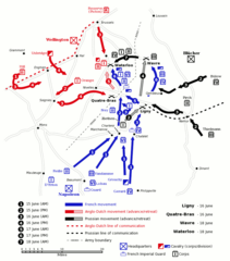
English: Map of force movements and major engagements during the Waterloo Campaign, June 15-18, 1815. Based on a map from The Oxford History of the British Army, 1994.
Español: Mapa táctico de la Batalla de Waterloo, basado en un mapa del libro The Oxford History of the British Army, 1994.
中文:滑鐵盧戰役中,1815年6月15-18日,軍力運動與主要交戰示意圖。 根據1994年The Oxford History of the British Army的一幅地圖。
| This work has been released into the public domain by its author, Gsl. This applies worldwide. In some countries this may not be legally possible; if so: |
ಕಡತದ ಇತಿಹಾಸ
ದಿನ/ಕಾಲ ಒತ್ತಿದರೆ ಆ ಸಮಯದಲ್ಲಿ ಈ ಕಡತದ ವಸ್ತುಸ್ಥಿತಿ ತೋರುತ್ತದೆ.
| ದಿನ/ಕಾಲ | ಕಿರುನೋಟ | ಆಯಾಮಗಳು | ಬಳಕೆದಾರ | ಟಿಪ್ಪಣಿ | |
|---|---|---|---|---|---|
| ಪ್ರಸಕ್ತ | ೧೪:೫೧, ೧೦ ಜನವರಿ ೨೦೦೬ | | ೮೦೦ × ೯೧೦ (೪೩ KB) | Gsl~commonswiki | 3rd version: reinstated french move ligny -> qb, prussian iv corps movement to wavre |
| ೧೪:೫೦, ೧೦ ಜನವರಿ ೨೦೦೬ |  | ೮೦೦ × ೯೧೦ (೩೫ KB) | Gsl~commonswiki | 2nd version, fixed errors, add scale, expand key, prussian colour scheme | |
| ೧೪:೪೯, ೧೦ ಜನವರಿ ೨೦೦೬ |  | ೮೦೦ × ೮೯೨ (೮೨ KB) | Gsl~commonswiki | original version from en.wikipedia.org | |
| ೨೦:೩೦, ೧೪ ಸೆಪ್ಟೆಂಬರ್ ೨೦೦೫ |  | ೮೦೦ × ೯೧೦ (೪೩ KB) | Mattes | new | |
| ೨೨:೧೬, ೨೧ ಜುಲೈ ೨೦೦೫ |  | ೮೦೦ × ೯೧೦ (೪೩ KB) | Dbenbenn | from w:Image:Waterloo campaign map.png by w:User:Gsl, PD |
ಕಡತ ಬಳಕೆ
ಈ ಫೈಲನ್ನು ಬಳಸುವ ಯಾವ ಪುಟಗಳೂ ಇಲ್ಲ.
ಜಾಗತಿಕ ಕಡತ ಉಪಯೋಗ
ಈ ಕಡತವನ್ನು ಕೆಳಗಿನ ಬೇರೆ ವಿಕಿಗಳೂ ಉಪಯೋಗಿಸುತ್ತಿವೆ:
- ast.wikipedia.org ಮೇಲೆ ಬಳಕೆ
- en.wikipedia.org ಮೇಲೆ ಬಳಕೆ
- eo.wikipedia.org ಮೇಲೆ ಬಳಕೆ
- eo.wikiquote.org ಮೇಲೆ ಬಳಕೆ
- es.wikipedia.org ಮೇಲೆ ಬಳಕೆ
- eu.wikipedia.org ಮೇಲೆ ಬಳಕೆ
- fi.wikipedia.org ಮೇಲೆ ಬಳಕೆ
- gl.wikipedia.org ಮೇಲೆ ಬಳಕೆ
- he.wikipedia.org ಮೇಲೆ ಬಳಕೆ
- hi.wikipedia.org ಮೇಲೆ ಬಳಕೆ
- hu.wikipedia.org ಮೇಲೆ ಬಳಕೆ
- id.wikipedia.org ಮೇಲೆ ಬಳಕೆ
- it.wikipedia.org ಮೇಲೆ ಬಳಕೆ
- ja.wikipedia.org ಮೇಲೆ ಬಳಕೆ
- ja.wikibooks.org ಮೇಲೆ ಬಳಕೆ
- ko.wikipedia.org ಮೇಲೆ ಬಳಕೆ
- lmo.wikipedia.org ಮೇಲೆ ಬಳಕೆ
- nl.wikipedia.org ಮೇಲೆ ಬಳಕೆ
- pl.wikipedia.org ಮೇಲೆ ಬಳಕೆ
- pt.wikipedia.org ಮೇಲೆ ಬಳಕೆ
- ro.wikipedia.org ಮೇಲೆ ಬಳಕೆ
- ru.wikipedia.org ಮೇಲೆ ಬಳಕೆ
- sh.wikipedia.org ಮೇಲೆ ಬಳಕೆ
- sr.wikipedia.org ಮೇಲೆ ಬಳಕೆ
- www.wikidata.org ಮೇಲೆ ಬಳಕೆ