ಚಿತ್ರ:Toronto map.png

ಈ ಮುನ್ನೋಟ ಗಾತ್ರ:೮೦೦ × ೫೯೫ ಪಿಕ್ಸೆಲ್ಗಳು. ಇತರ ರೆಸಲ್ಯೂಶನ್ಗಳು: ೩೨೦ × ೨೩೮ ಪಿಕ್ಸೆಲ್ಗಳು | ೬೪೦ × ೪೭೬ ಪಿಕ್ಸೆಲ್ಗಳು | ೧,೦೨೪ × ೭೬೧ ಪಿಕ್ಸೆಲ್ಗಳು | ೧,೨೮೦ × ೯೫೧ ಪಿಕ್ಸೆಲ್ಗಳು | ೧,೫೦೦ × ೧,೧೧೫ ಪಿಕ್ಸೆಲ್ಗಳು.
ಮೂಲ ಕಡತ (೧,೫೦೦ × ೧,೧೧೫ ಚಿತ್ರಬಿಂದು, ಫೈಲಿನ ಗಾತ್ರ: ೭೦೩ KB, MIME ಪ್ರಕಾರ: image/png)
ಈ ಫೈಲು ವಿಕಿಮೀಡಿಯ ಕಾಮನ್ಸ್ನಲ್ಲಿ ಇರುವುದು. ಅಲ್ಲಿನ ವಿವರಣೆ ಪುಟವನ್ನೇ ಕೆಳಗೆ ತೋರಿಸಲಾಗಿದೆ. ಕಾಮನ್ಸ್ ಕೃತಿಸ್ವಾಮ್ಯತೆಯಿಂದ ಮುಕ್ತ ಫೈಲುಗಳ ಒಂದು ಆಗರ. ಅಲ್ಲಿ ನೀವೂ ಸಹಕರಿಸಬಹುದು. |
|
| ವಿವರ |
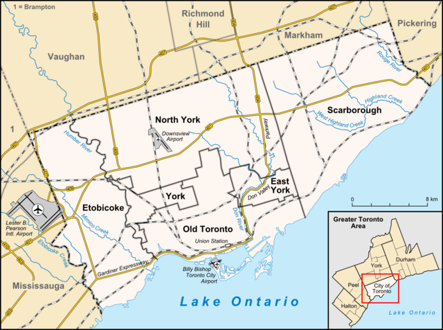
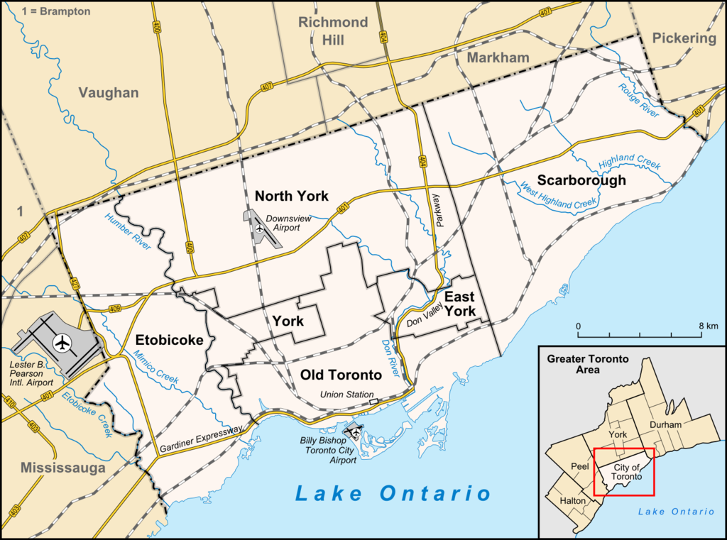
English: Map of Toronto
Français : Carte de Toronto
Deutsch: Karte von Toronto
Bahasa Indonesia: Peta kota Toronto |
| ದಿನಾಂಕ | |
| ಆಕರ |
own work, used:
|
| ಕರ್ತೃ | Lencer |

|
This map has been made or improved in the German Kartenwerkstatt (Map Lab). You can propose maps to improve as well.
|
ಈ ಕಡತ ಕ್ರಿಯೇಟಿವ್ ಕಾಮನ್ಸ್ Attribution
-Share Alike 3.0 Unported ಪರವಾನಗಿ ಹೊಂದಿದೆ.
- ನೀವು ಮುಕ್ತ:
- ಹಂಚಿಕೆಗೆ – ಕೆಲಸವನ್ನು ನಕಲು ಮಾಡಲು, ವಿತರಣೆ ಮತ್ತು ಸಾಗಿಸಲು
- ರೀಮಿಕ್ಸ್ ಮಾಡಲು – ಕೆಲಸವನ್ನು ಬಳಸಿಕೊಳ್ಳಲು
- ಈ ಕೆಳಗಿನ ಷರತ್ತುಗಳಲ್ಲಿ:
- ವೈಶಿಷ್ಟ್ಯ – ನೀವು ಸೂಕ್ತವಾದ ಕ್ರೆಡಿಟ್ ನೀಡಬೇಕು, ಪರವಾನಗಿಗೆ ಲಿಂಕ್ ಅನ್ನು ಒದಗಿಸಬೇಕು ಮತ್ತು ಯಾವುದೇ ಬದಲಾವಣೆಗಳನ್ನು ಮಾಡಿದ್ದರೆ ಸೂಚಿಸಬೇಕು. ನೀವು ಯಾವುದೇ ಸಮಂಜಸವಾದ ರೀತಿಯಲ್ಲಿ ಮಾಡಬಹುದು, ಆದರೆ ಪರವಾನಗಿದಾರರು ನಿಮ್ಮನ್ನು ಅಥವಾ ನಿಮ್ಮ ಯಾವುದೇ ಬಳಕೆಯನ್ನು ಅನುಮೋದಿಸಿದಂತೆ ರೀತಿಯಲ್ಲಿ ಉಪಯೋಗಿಸಬಾರದು.
- ಇರುವುದರಂತೆಯೇ ಹಂಚು – ನೀವು ರೀಮಿಕ್ಸ್ ಮಾಡಿದರೆ, ರೂಪಾಂತರಗೊಳಿಸಿದರೆ ಅಥವಾ ವಸ್ತುವಿನ ಮೇಲೆ ನಿರ್ಮಿಸಿದರೆ, ನಿಮ್ಮ ಕೊಡುಗೆಗಳನ್ನು ನೀವು ಮೂಲದಂತೆ ಅದೇ ಅಥವಾ ಹೊಂದಾಣಿಕೆಯ ಪರವಾನಗಿ ಅಡಿಯಲ್ಲಿ ವಿತರಿಸಬೇಕು.
ಕಡತದ ಇತಿಹಾಸ
ದಿನ/ಕಾಲ ಒತ್ತಿದರೆ ಆ ಸಮಯದಲ್ಲಿ ಈ ಕಡತದ ವಸ್ತುಸ್ಥಿತಿ ತೋರುತ್ತದೆ.
| ದಿನ/ಕಾಲ | ಕಿರುನೋಟ | ಆಯಾಮಗಳು | ಬಳಕೆದಾರ | ಟಿಪ್ಪಣಿ | |
|---|---|---|---|---|---|
| ಪ್ರಸಕ್ತ | ೨೦:೦೩, ೩ ಏಪ್ರಿಲ್ ೨೦೧೨ | | ೧,೫೦೦ × ೧,೧೧೫ (೭೦೩ KB) | Lencer | + don river, minor adds of river names |
| ೨೧:೨೯, ೨೯ ಜೂನ್ ೨೦೦೯ |  | ೧,೫೦೦ × ೧,೧೧೫ (೫೮೫ KB) | SimonP | correct minor error | |
| ೨೦:೪೮, ೨೯ ಜೂನ್ ೨೦೦೯ |  | ೧,೫೦೦ × ೧,೧೧೫ (೫೮೫ KB) | SimonP | Corect East York border | |
| ೧೬:೨೬, ೧೮ ಜೂನ್ ೨೦೦೯ |  | ೧,೫೦೦ × ೧,೧೧೫ (೬೭೭ KB) | Lencer | + don valley parkway | |
| ೦೦:೨೬, ೨೬ ಮಾರ್ಚ್ ೨೦೦೯ |  | ೧,೫೦೦ × ೧,೧೧೫ (೬೭೩ KB) | Lencer | Int. => Intl. | |
| ೧೭:೪೯, ೧೮ ಮಾರ್ಚ್ ೨೦೦೯ |  | ೧,೫೦೦ × ೧,೧೧೫ (೬೭೨ KB) | Lencer | Vaugahn -> Vaughan | |
| ೧೨:೨೪, ೧೦ ಮಾರ್ಚ್ ೨೦೦೯ |  | ೧,೫೦೦ × ೧,೧೧೫ (೬೭೩ KB) | Lencer | fix Greater Toronto Area | |
| ೧೭:೫೯, ೯ ಮಾರ್ಚ್ ೨೦೦೯ |  | ೧,೫೦೦ × ೧,೧೧೫ (೬೭೨ KB) | Lencer | + Minimap, some fixes | |
| ೦೦:೪೦, ೯ ಮಾರ್ಚ್ ೨೦೦೯ |  | ೧,೫೦೦ × ೧,೧೧೬ (೬೨೮ KB) | Lencer | weitere Kartenelemente erg., Farben geändert | |
| ೦೧:೩೨, ೩ ಮಾರ್ಚ್ ೨೦೦೯ |  | ೧,೫೦೦ × ೧,೧೧೬ (೪೭೫ KB) | Lencer | Fehlerhafte Grenze bei York |
ಕಡತ ಬಳಕೆ
ಈ ಕೆಳಗಿನ ಪುಟವು ಈ ಚಿತ್ರಕ್ಕೆ ಸಂಪರ್ಕ ಹೊಂದಿದೆ:
ಜಾಗತಿಕ ಕಡತ ಉಪಯೋಗ
ಈ ಕಡತವನ್ನು ಕೆಳಗಿನ ಬೇರೆ ವಿಕಿಗಳೂ ಉಪಯೋಗಿಸುತ್ತಿವೆ:
- ar.wikipedia.org ಮೇಲೆ ಬಳಕೆ
- ban.wikipedia.org ಮೇಲೆ ಬಳಕೆ
- ceb.wikipedia.org ಮೇಲೆ ಬಳಕೆ
- ckb.wikipedia.org ಮೇಲೆ ಬಳಕೆ
- de.wikipedia.org ಮೇಲೆ ಬಳಕೆ
- Toronto
- Benutzer:Lencer
- Wikipedia:Exzellente Bilder/Karten und Satellitenbilder
- Liste der Ortsteile von Toronto
- Wikipedia:Kartenwerkstatt/Archiv/2009-03
- Wikipedia:Kandidaten für exzellente Bilder/Archiv2009/6
- Datei:Toronto map.png
- Toronto Fire Services
- Taber Hill
- Wikipedia:Kartenwerkstatt/Schaufenster
- Wikipedia:Exzellente Bilder/Kleine Bilder
- en.wikipedia.org ಮೇಲೆ ಬಳಕೆ
- Toronto
- Rogers Centre
- Yonge–Dundas Square
- Billy Bishop Toronto City Airport
- Don River (Ontario)
- Forest Hill, Toronto
- Humber River (Ontario)
- The Annex
- Royal Ontario Museum
- Cabbagetown, Toronto
- Rosedale, Toronto
- The Beaches, Toronto
- High Park
- The Kingsway, Toronto
- Baby Point
- Bendale
- The Junction
- Little Italy, Toronto
- New Toronto
- Leslieville
- Kensington Market
- Scotiabank Arena
- Riverdale, Toronto
- Metropolitan Toronto
- Union Station (Toronto)
- Swansea, Toronto
- Parkdale, Toronto
- Rouge River (Ontario)
- Ontario Science Centre
- Black Creek Pioneer Village
- Agincourt, Toronto
ಈ ಫೈಲ್ನ ಹೆಚ್ಚು ಜಾಗತಿಕ ಬಳಕೆಯನ್ನು ವೀಕ್ಷಿಸಿ.