ಚಿತ್ರ:Sweden Blekinge location map.svg

Size of this PNG preview of this SVG file: ೮೦೦ × ೩೯೮ ಪಿಕ್ಸೆಲ್ಗಳು. ಇತರ ರೆಸಲ್ಯೂಶನ್ಗಳು: ೩೨೦ × ೧೫೯ ಪಿಕ್ಸೆಲ್ಗಳು | ೬೪೦ × ೩೧೯ ಪಿಕ್ಸೆಲ್ಗಳು | ೧,೦೨೪ × ೫೧೦ ಪಿಕ್ಸೆಲ್ಗಳು | ೧,೨೮೦ × ೬೩೭ ಪಿಕ್ಸೆಲ್ಗಳು | ೨,೫೬೦ × ೧,೨೭೫ ಪಿಕ್ಸೆಲ್ಗಳು | ೧,೦೦೦ × ೪೯೮ ಪಿಕ್ಸೆಲ್ಗಳು.
ಮೂಲ ಕಡತ (SVG ಫೈಲು, ಸುಮಾರಾಗಿ ೧,೦೦೦ × ೪೯೮ ಚಿತ್ರಬಿಂದುಗಳು, ಫೈಲಿನ ಗಾತ್ರ: ೧೬೬ KB)
ಈ ಫೈಲು ವಿಕಿಮೀಡಿಯ ಕಾಮನ್ಸ್ನಲ್ಲಿ ಇರುವುದು. ಅಲ್ಲಿನ ವಿವರಣೆ ಪುಟವನ್ನೇ ಕೆಳಗೆ ತೋರಿಸಲಾಗಿದೆ. ಕಾಮನ್ಸ್ ಕೃತಿಸ್ವಾಮ್ಯತೆಯಿಂದ ಮುಕ್ತ ಫೈಲುಗಳ ಒಂದು ಆಗರ. ಅಲ್ಲಿ ನೀವೂ ಸಹಕರಿಸಬಹುದು. |
ಸಾರಾಂಶ
| ವಿವರ |
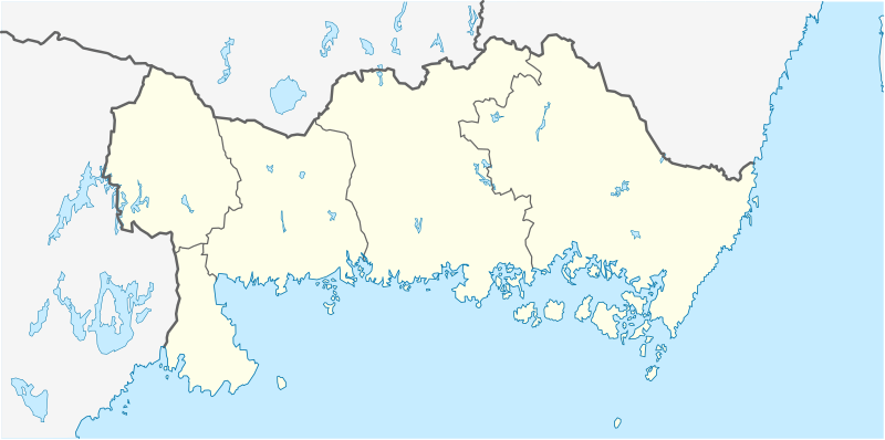
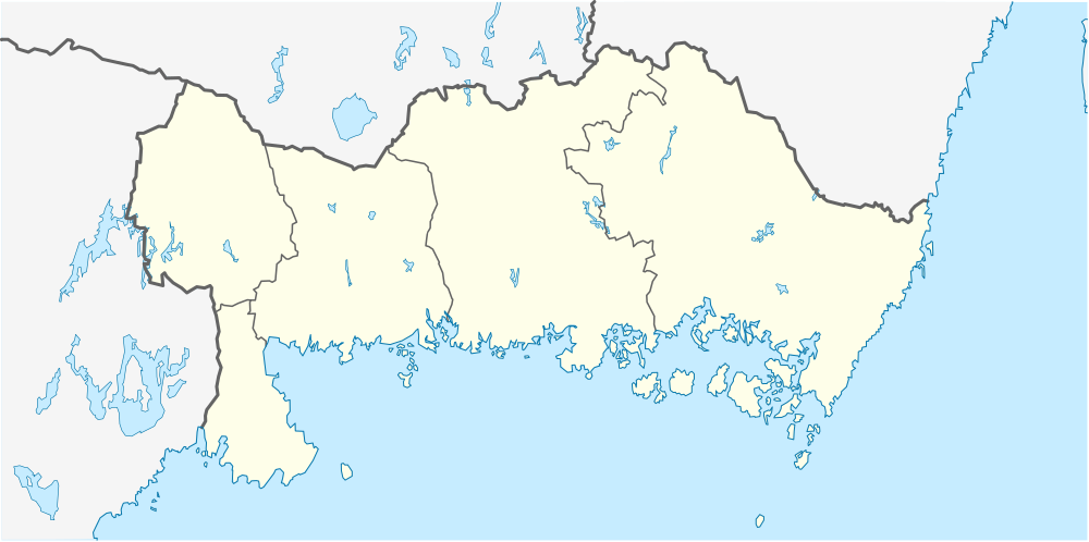
English: Location map of Blekinge County in Sweden
Equirectangular projection, N/S stretching 182 %. Geographic limits of the map:
Deutsch: Positionskarte von Blekinge län in Schweden
Quadratische Plattkarte, N-S-Streckung 182 %. Geographische Begrenzung der Karte:
|
| ದಿನಾಂಕ | |
| ಆಕರ | ಸ್ವಂತ ಕೆಲಸ |
| ಕರ್ತೃ | Erik Frohne |
ಪರವಾನಗಿ
I, the copyright holder of this work, hereby publish it under the following licenses:

|
GNU ಉಚಿತ ಡಾಕ್ಯುಮೆಂಟೇಶನ್ ಪರವಾನಗಿ, ಆವೃತ್ತಿಯ ನಿಯಮಗಳ ಅಡಿಯಲ್ಲಿ ಈ ಡಾಕ್ಯುಮೆಂಟ್ ಅನ್ನು ನಕಲಿಸಲು, ವಿತರಿಸಲು ಮತ್ತು/ಅಥವಾ ಮಾರ್ಪಡಿಸಲು ಅನುಮತಿಯನ್ನು ನೀಡಲಾಗಿದೆ. 1.2 ಅಥವಾ ಯಾವುದೇ ನಂತರದ ಆವೃತ್ತಿಯನ್ನು ಉಚಿತ ಸಾಫ್ಟ್ವೇರ್ ಫೌಂಡೇಶನ್ ಪ್ರಕಟಿಸಿದೆ; ಯಾವುದೇ ಅಸ್ಥಿರ ವಿಭಾಗಗಳಿಲ್ಲದೆ, ಮುಖ ಪಠ್ಯಗಳಿಲ್ಲ ಮತ್ತು ಹಿಂದಿನ ಕವರ್ ಪಠ್ಯಗಳಿಲ್ಲ. ಪರವಾನಗಿಯ ಪ್ರತಿಯನ್ನು GNU ಉಚಿತ ಡಾಕ್ಯುಮೆಂಟೇಶನ್ ಪರವಾನಗಿ ಎಂಬ ವಿಭಾಗದಲ್ಲಿ ಸೇರಿಸಲಾಗಿದೆ. |
This file is licensed under the Creative Commons Attribution 3.0 Unported license.
- ನೀವು ಮುಕ್ತ:
- ಹಂಚಿಕೆಗೆ – ಕೆಲಸವನ್ನು ನಕಲು ಮಾಡಲು, ವಿತರಣೆ ಮತ್ತು ಸಾಗಿಸಲು
- ರೀಮಿಕ್ಸ್ ಮಾಡಲು – ಕೆಲಸವನ್ನು ಬಳಸಿಕೊಳ್ಳಲು
- ಈ ಕೆಳಗಿನ ಷರತ್ತುಗಳಲ್ಲಿ:
- ವೈಶಿಷ್ಟ್ಯ – ನೀವು ಸೂಕ್ತವಾದ ಕ್ರೆಡಿಟ್ ನೀಡಬೇಕು, ಪರವಾನಗಿಗೆ ಲಿಂಕ್ ಅನ್ನು ಒದಗಿಸಬೇಕು ಮತ್ತು ಯಾವುದೇ ಬದಲಾವಣೆಗಳನ್ನು ಮಾಡಿದ್ದರೆ ಸೂಚಿಸಬೇಕು. ನೀವು ಯಾವುದೇ ಸಮಂಜಸವಾದ ರೀತಿಯಲ್ಲಿ ಮಾಡಬಹುದು, ಆದರೆ ಪರವಾನಗಿದಾರರು ನಿಮ್ಮನ್ನು ಅಥವಾ ನಿಮ್ಮ ಯಾವುದೇ ಬಳಕೆಯನ್ನು ಅನುಮೋದಿಸಿದಂತೆ ರೀತಿಯಲ್ಲಿ ಉಪಯೋಗಿಸಬಾರದು.
ನಿಮ್ಮಿಚ್ಛೆಯ ಪರವಾನಗಿಯನ್ನು ನೀವು ಆರಿಸಿಕೊಳ್ಳಬಹುದು.
ಕಡತದ ಇತಿಹಾಸ
ದಿನ/ಕಾಲ ಒತ್ತಿದರೆ ಆ ಸಮಯದಲ್ಲಿ ಈ ಕಡತದ ವಸ್ತುಸ್ಥಿತಿ ತೋರುತ್ತದೆ.
| ದಿನ/ಕಾಲ | ಕಿರುನೋಟ | ಆಯಾಮಗಳು | ಬಳಕೆದಾರ | ಟಿಪ್ಪಣಿ | |
|---|---|---|---|---|---|
| ಪ್ರಸಕ್ತ | ೨೩:೧೨, ೨೬ ಜನವರಿ ೨೦೦೯ | | ೧,೦೦೦ × ೪೯೮ (೧೬೬ KB) | Erik Frohne | Smaller waterborder |
| ೦೪:೩೭, ೧೮ ಜನವರಿ ೨೦೦೯ |  | ೧,೦೦೦ × ೪೯೮ (೧೫೦ KB) | Erik Frohne | {{Information |Description= |Source= |Date= |Author= |Permission= |other_versions= }} Category:Location maps of Sweden | |
| ೧೪:೧೯, ೨ ಜನವರಿ ೨೦೦೯ |  | ೧೫೩ × ೮೦ (೬೭ KB) | Erik Frohne | {{Information |Description=Update (gray out other län) |Source=Own work |Date=02-Jan-2009 |Author=Erik Frohne |Permission=see below |other_versions= }} | |
| ೦೧:೩೮, ೨ ಜನವರಿ ೨೦೦೯ |  | ೧೫೩ × ೮೦ (೨೯ KB) | Erik Frohne | {{Information |Description=Addition of municipiality |Source=Own work |Date=01-01-2009 |Author=Erik Frohne |Permission= |other_versions= }} Category:Location maps of Europe | |
| ೨೨:೪೪, ೧ ಜನವರಿ ೨೦೦೯ |  | ೧೫೩ × ೮೦ (೨೩ KB) | Erik Frohne | {{Information |Description={{en|1=Location map of Blekinge in Sweden Equirectangular projection, N/S stretching 190 %. Geographic limits of the map: * N: 56° 33' N * S: 55° 56' N * W: 14° 08' E * E: 16° 23' E }} {{de|1=Positionskarte von Schonen |
ಕಡತ ಬಳಕೆ
ಈ ಕೆಳಗಿನ ಪುಟವು ಈ ಚಿತ್ರಕ್ಕೆ ಸಂಪರ್ಕ ಹೊಂದಿದೆ:
ಜಾಗತಿಕ ಕಡತ ಉಪಯೋಗ
ಈ ಕಡತವನ್ನು ಕೆಳಗಿನ ಬೇರೆ ವಿಕಿಗಳೂ ಉಪಯೋಗಿಸುತ್ತಿವೆ:
- ar.wikipedia.org ಮೇಲೆ ಬಳಕೆ
- bg.wikipedia.org ಮೇಲೆ ಬಳಕೆ
- ceb.wikipedia.org ಮೇಲೆ ಬಳಕೆ
- cs.wikipedia.org ಮೇಲೆ ಬಳಕೆ
- da.wikipedia.org ಮೇಲೆ ಬಳಕೆ
- Karlskrona
- Ronneby
- Karlshamn
- Olofström
- Sölvesborg
- Kristianopel
- Elleholm
- Sølvesborg Slotsruin
- Lyckeby
- Nättraby
- Brömsebro
- Skabelon:Kortpositioner Sverige Blekinge
- Bräkne-Hoby
- Järnavik
- Rödeby
- Drottningskär
- Fridlevstad
- Fågelmara
- Hasslö
- Holmsjö
- Jämjö
- Kättilsmåla
- Torhamn
- Mörrum
- Hällaryd
- Mjällby
- Svängsta
- Trolleboda (Ronneby kommun)
- Backaryd
- Åryd (Blekinge)
- Bruger:DykplatserISverige/Vragkirkegården ved Ekenabben
- de.wikipedia.org ಮೇಲೆ ಬಳಕೆ
ಈ ಫೈಲ್ನ ಹೆಚ್ಚು ಜಾಗತಿಕ ಬಳಕೆಯನ್ನು ವೀಕ್ಷಿಸಿ.