ಚಿತ್ರ:Persian Empire Abraham Ortelius.jpg

ಈ ಮುನ್ನೋಟ ಗಾತ್ರ:೪೬೧ × ೫೯೯ ಪಿಕ್ಸೆಲ್ಗಳು. ಇತರ ರೆಸಲ್ಯೂಶನ್ಗಳು: ೧೮೪ × ೨೪೦ ಪಿಕ್ಸೆಲ್ಗಳು | ೬೧೦ × ೭೯೩ ಪಿಕ್ಸೆಲ್ಗಳು.
ಮೂಲ ಕಡತ (೬೧೦ × ೭೯೩ ಚಿತ್ರಬಿಂದು, ಫೈಲಿನ ಗಾತ್ರ: ೩೪೦ KB, MIME ಪ್ರಕಾರ: image/jpeg)
ಈ ಫೈಲು ವಿಕಿಮೀಡಿಯ ಕಾಮನ್ಸ್ನಲ್ಲಿ ಇರುವುದು. ಅಲ್ಲಿನ ವಿವರಣೆ ಪುಟವನ್ನೇ ಕೆಳಗೆ ತೋರಿಸಲಾಗಿದೆ. ಕಾಮನ್ಸ್ ಕೃತಿಸ್ವಾಮ್ಯತೆಯಿಂದ ಮುಕ್ತ ಫೈಲುಗಳ ಒಂದು ಆಗರ. ಅಲ್ಲಿ ನೀವೂ ಸಹಕರಿಸಬಹುದು. |
ಸಾರಾಂಶ
| ವಿವರ |
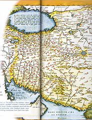
English: The Kingdom of Persian, this map was created by Dutch cartographer Abraham Ortelius, the first modern Atlas, and was printed from 1570 to 1624
فارسی: پادشاهی ایران، این نقشه توسط کارتوگرافر بلژیکی «آبراهام ارتلیوس» ساخته شده که در نخستین اطلس نوین در میان سالهای ۱۵۷۰ تا ۱۶۲۴ چاپ شدهاست |
|||||||||||||||||||||||
| ದಿನಾಂಕ | to 1624. | |||||||||||||||||||||||
| ಆಕರ | Fred Ramen, A historical atlas of Iran, published in 2003 | |||||||||||||||||||||||
| ಕರ್ತೃ |
|
|||||||||||||||||||||||

ಪರವಾನಗಿ
|
This is a faithful photographic reproduction of a two-dimensional, public domain work of art. The work of art itself is in the public domain for the following reason:
The official position taken by the Wikimedia Foundation is that "faithful reproductions of two-dimensional public domain works of art are public domain".
This photographic reproduction is therefore also considered to be in the public domain in the United States. In other jurisdictions, re-use of this content may be restricted; see Reuse of PD-Art photographs for details. | ||||
ಕಡತದ ಇತಿಹಾಸ
ದಿನ/ಕಾಲ ಒತ್ತಿದರೆ ಆ ಸಮಯದಲ್ಲಿ ಈ ಕಡತದ ವಸ್ತುಸ್ಥಿತಿ ತೋರುತ್ತದೆ.
| ದಿನ/ಕಾಲ | ಕಿರುನೋಟ | ಆಯಾಮಗಳು | ಬಳಕೆದಾರ | ಟಿಪ್ಪಣಿ | |
|---|---|---|---|---|---|
| ಪ್ರಸಕ್ತ | ೧೭:೫೦, ೮ ಅಕ್ಟೋಬರ್ ೨೦೦೮ | | ೬೧೦ × ೭೯೩ (೩೪೦ KB) | Wayiran | {{Information |Description={{en|1=The Kingdom of Persian, this map was created by Dutch cartographer Abraham Ortelius, the first modern Atlas, and was printed from 1570 to 1624}} {{fa|1=پادشاهی ایران، این نقشه توسط کارتوگرا |
ಕಡತ ಬಳಕೆ
ಈ ಕೆಳಗಿನ ಪುಟವು ಈ ಚಿತ್ರಕ್ಕೆ ಸಂಪರ್ಕ ಹೊಂದಿದೆ:
ಜಾಗತಿಕ ಕಡತ ಉಪಯೋಗ
ಈ ಕಡತವನ್ನು ಕೆಳಗಿನ ಬೇರೆ ವಿಕಿಗಳೂ ಉಪಯೋಗಿಸುತ್ತಿವೆ:
- azb.wikipedia.org ಮೇಲೆ ಬಳಕೆ
- cs.wikipedia.org ಮೇಲೆ ಬಳಕೆ
- en.wikipedia.org ಮೇಲೆ ಬಳಕೆ
- eo.wikipedia.org ಮೇಲೆ ಬಳಕೆ
- fa.wikipedia.org ಮೇಲೆ ಬಳಕೆ
- he.wikipedia.org ಮೇಲೆ ಬಳಕೆ
- hi.wikipedia.org ಮೇಲೆ ಬಳಕೆ
- ja.wikipedia.org ಮೇಲೆ ಬಳಕೆ
- ko.wikipedia.org ಮೇಲೆ ಬಳಕೆ
- la.wikipedia.org ಮೇಲೆ ಬಳಕೆ
- pnb.wikipedia.org ಮೇಲೆ ಬಳಕೆ
- pt.wikipedia.org ಮೇಲೆ ಬಳಕೆ
- ro.wikipedia.org ಮೇಲೆ ಬಳಕೆ
- ru.wikipedia.org ಮೇಲೆ ಬಳಕೆ
- sl.wikipedia.org ಮೇಲೆ ಬಳಕೆ
- tr.wikipedia.org ಮೇಲೆ ಬಳಕೆ
- ur.wikipedia.org ಮೇಲೆ ಬಳಕೆ