ಚಿತ್ರ:Map of Ajatashatru's kingdom.jpg

ಈ ಮುನ್ನೋಟ ಗಾತ್ರ:೪೪೯ × ೫೯೯ ಪಿಕ್ಸೆಲ್ಗಳು. ಇತರ ರೆಸಲ್ಯೂಶನ್ಗಳು: ೧೮೦ × ೨೪೦ ಪಿಕ್ಸೆಲ್ಗಳು | ೩೬೦ × ೪೮೦ ಪಿಕ್ಸೆಲ್ಗಳು | ೫೭೬ × ೭೬೮ ಪಿಕ್ಸೆಲ್ಗಳು | ೭೬೮ × ೧,೦೨೪ ಪಿಕ್ಸೆಲ್ಗಳು | ೨,೦೦೦ × ೨,೬೬೭ ಪಿಕ್ಸೆಲ್ಗಳು.
ಮೂಲ ಕಡತ (೨,೦೦೦ × ೨,೬೬೭ ಚಿತ್ರಬಿಂದು, ಫೈಲಿನ ಗಾತ್ರ: ೧.೯೬ MB, MIME ಪ್ರಕಾರ: image/jpeg)
ಈ ಫೈಲು ವಿಕಿಮೀಡಿಯ ಕಾಮನ್ಸ್ನಲ್ಲಿ ಇರುವುದು. ಅಲ್ಲಿನ ವಿವರಣೆ ಪುಟವನ್ನೇ ಕೆಳಗೆ ತೋರಿಸಲಾಗಿದೆ. ಕಾಮನ್ಸ್ ಕೃತಿಸ್ವಾಮ್ಯತೆಯಿಂದ ಮುಕ್ತ ಫೈಲುಗಳ ಒಂದು ಆಗರ. ಅಲ್ಲಿ ನೀವೂ ಸಹಕರಿಸಬಹುದು. |

ಸಾರಾಂಶ
| ವಿವರ |
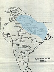
English: Map of 600BC India with colored area as approx. Ajatasatru's Kingdom. |
| ದಿನಾಂಕ | |
| ಆಕರ | ಸ್ವಂತ ಕೆಲಸ |
| ಕರ್ತೃ | Coolnim |
ಪರವಾನಗಿ
I, the copyright holder of this work, hereby publish it under the following license:
This file is licensed under the Creative Commons Attribution 3.0 Unported license.
- ನೀವು ಮುಕ್ತ:
- ಹಂಚಿಕೆಗೆ – ಕೆಲಸವನ್ನು ನಕಲು ಮಾಡಲು, ವಿತರಣೆ ಮತ್ತು ಸಾಗಿಸಲು
- ರೀಮಿಕ್ಸ್ ಮಾಡಲು – ಕೆಲಸವನ್ನು ಬಳಸಿಕೊಳ್ಳಲು
- ಈ ಕೆಳಗಿನ ಷರತ್ತುಗಳಲ್ಲಿ:
- ವೈಶಿಷ್ಟ್ಯ – ನೀವು ಸೂಕ್ತವಾದ ಕ್ರೆಡಿಟ್ ನೀಡಬೇಕು, ಪರವಾನಗಿಗೆ ಲಿಂಕ್ ಅನ್ನು ಒದಗಿಸಬೇಕು ಮತ್ತು ಯಾವುದೇ ಬದಲಾವಣೆಗಳನ್ನು ಮಾಡಿದ್ದರೆ ಸೂಚಿಸಬೇಕು. ನೀವು ಯಾವುದೇ ಸಮಂಜಸವಾದ ರೀತಿಯಲ್ಲಿ ಮಾಡಬಹುದು, ಆದರೆ ಪರವಾನಗಿದಾರರು ನಿಮ್ಮನ್ನು ಅಥವಾ ನಿಮ್ಮ ಯಾವುದೇ ಬಳಕೆಯನ್ನು ಅನುಮೋದಿಸಿದಂತೆ ರೀತಿಯಲ್ಲಿ ಉಪಯೋಗಿಸಬಾರದು.
ಕಡತದ ಇತಿಹಾಸ
ದಿನ/ಕಾಲ ಒತ್ತಿದರೆ ಆ ಸಮಯದಲ್ಲಿ ಈ ಕಡತದ ವಸ್ತುಸ್ಥಿತಿ ತೋರುತ್ತದೆ.
| ದಿನ/ಕಾಲ | ಕಿರುನೋಟ | ಆಯಾಮಗಳು | ಬಳಕೆದಾರ | ಟಿಪ್ಪಣಿ | |
|---|---|---|---|---|---|
| ಪ್ರಸಕ್ತ | ೦೦:೨೨, ೩ ಜುಲೈ ೨೦೧೧ | | ೨,೦೦೦ × ೨,೬೬೭ (೧.೯೬ MB) | Coolnim | Improved rectified version |
| ೦೦:೦೭, ೩ ಜುಲೈ ೨೦೧೧ |  | ೨,೦೦೦ × ೨,೬೬೭ (೨ MB) | Coolnim | {{Information |Description ={{en|1=Map of 600BC India with colored area as approx. Ajatasatru's Kingdom.}} |Source ={{own}} |Author =Coolnim |Date =2011-07-02 |Permission = |other_versions = }} |
ಕಡತ ಬಳಕೆ
ಈ ಕೆಳಗಿನ ಪುಟವು ಈ ಚಿತ್ರಕ್ಕೆ ಸಂಪರ್ಕ ಹೊಂದಿದೆ:
ಜಾಗತಿಕ ಕಡತ ಉಪಯೋಗ
ಈ ಕಡತವನ್ನು ಕೆಳಗಿನ ಬೇರೆ ವಿಕಿಗಳೂ ಉಪಯೋಗಿಸುತ್ತಿವೆ:
- hu.wikipedia.org ಮೇಲೆ ಬಳಕೆ
- it.wikipedia.org ಮೇಲೆ ಬಳಕೆ