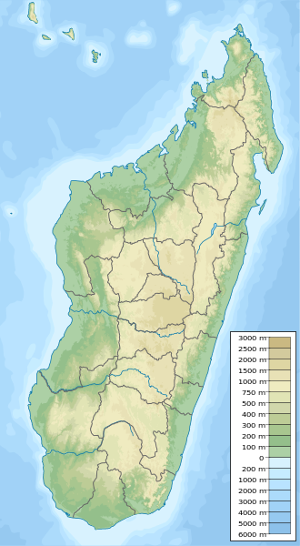
ಚಿತ್ರ:Madagascar physical map.svg

Size of this PNG preview of this SVG file: ೩೩೦ × ೬೦೦ ಪಿಕ್ಸೆಲ್ಗಳು. ಇತರ ರೆಸಲ್ಯೂಶನ್ಗಳು: ೧೩೨ × ೨೪೦ ಪಿಕ್ಸೆಲ್ಗಳು | ೨೬೪ × ೪೮೦ ಪಿಕ್ಸೆಲ್ಗಳು | ೪೨೨ × ೭೬೮ ಪಿಕ್ಸೆಲ್ಗಳು | ೫೬೩ × ೧,೦೨೪ ಪಿಕ್ಸೆಲ್ಗಳು | ೧,೧೨೭ × ೨,೦೪೮ ಪಿಕ್ಸೆಲ್ಗಳು | ೪೨೬ × ೭೭೪ ಪಿಕ್ಸೆಲ್ಗಳು.
ಮೂಲ ಕಡತ (SVG ಫೈಲು, ಸುಮಾರಾಗಿ ೪೨೬ × ೭೭೪ ಚಿತ್ರಬಿಂದುಗಳು, ಫೈಲಿನ ಗಾತ್ರ: ೨.೨ MB)
ಈ ಫೈಲು ವಿಕಿಮೀಡಿಯ ಕಾಮನ್ಸ್ನಲ್ಲಿ ಇರುವುದು. ಅಲ್ಲಿನ ವಿವರಣೆ ಪುಟವನ್ನೇ ಕೆಳಗೆ ತೋರಿಸಲಾಗಿದೆ. ಕಾಮನ್ಸ್ ಕೃತಿಸ್ವಾಮ್ಯತೆಯಿಂದ ಮುಕ್ತ ಫೈಲುಗಳ ಒಂದು ಆಗರ. ಅಲ್ಲಿ ನೀವೂ ಸಹಕರಿಸಬಹುದು. |
ಸಾರಾಂಶ
| ವಿವರ |
English: Physical map of Madagascar, parameters equal to Madagascar location map.svg. |
| ದಿನಾಂಕ | |
| ಆಕರ | ಸ್ವಂತ ಕೆಲಸ |
| ಕರ್ತೃ | Urutseg |
| SVG genesis |
ಪರವಾನಗಿ
| I, the copyright holder of this work, release this work into the public domain. This applies worldwide. In some countries this may not be legally possible; if so: I grant anyone the right to use this work for any purpose, without any conditions, unless such conditions are required by law. |
ಕಡತದ ಇತಿಹಾಸ
ದಿನ/ಕಾಲ ಒತ್ತಿದರೆ ಆ ಸಮಯದಲ್ಲಿ ಈ ಕಡತದ ವಸ್ತುಸ್ಥಿತಿ ತೋರುತ್ತದೆ.
| ದಿನ/ಕಾಲ | ಕಿರುನೋಟ | ಆಯಾಮಗಳು | ಬಳಕೆದಾರ | ಟಿಪ್ಪಣಿ | |
|---|---|---|---|---|---|
| ಪ್ರಸಕ್ತ | ೦೪:೩೯, ೧೩ ಮೇ ೨೦೨೩ | | ೪೨೬ × ೭೭೪ (೨.೨ MB) | GrandEscogriffe | adding two region borders: Atsinanana/Analanjirofo and Vatovavy-Fitovinany |
| ೦೦:೩೨, ೧೨ ಅಕ್ಟೋಬರ್ ೨೦೧೩ |  | ೪೨೬ × ೭೭೪ (೨.೧೭ MB) | NordNordWest | upd | |
| ೦೦:೫೬, ೧೪ ಫೆಬ್ರವರಿ ೨೦೧೧ |  | ೪೨೬ × ೭೭೪ (೨.೭೬ MB) | Urutseg | {{Information |Description ={{en|1=Physical map of Madagascar, parameters equal to File:Madagascar location map.svg.}} |Source ={{own}} |Author =Urutseg |Date =2011-02-13 |Permission = |other_version |
ಕಡತ ಬಳಕೆ
ಈ ಕೆಳಗಿನ ಪುಟವು ಈ ಚಿತ್ರಕ್ಕೆ ಸಂಪರ್ಕ ಹೊಂದಿದೆ:
ಜಾಗತಿಕ ಕಡತ ಉಪಯೋಗ
ಈ ಕಡತವನ್ನು ಕೆಳಗಿನ ಬೇರೆ ವಿಕಿಗಳೂ ಉಪಯೋಗಿಸುತ್ತಿವೆ:
- ar.wikipedia.org ಮೇಲೆ ಬಳಕೆ
- arz.wikipedia.org ಮೇಲೆ ಬಳಕೆ
- ast.wikipedia.org ಮೇಲೆ ಬಳಕೆ
- azb.wikipedia.org ಮೇಲೆ ಬಳಕೆ
- az.wikipedia.org ಮೇಲೆ ಬಳಕೆ
- ba.wikipedia.org ಮೇಲೆ ಬಳಕೆ
- be.wikipedia.org ಮೇಲೆ ಬಳಕೆ
- bg.wikipedia.org ಮೇಲೆ ಬಳಕೆ
- Антананариву
- Шаблон:ПК Мадагаскар
- Анцирабе
- Амбатулямпи
- Бетафо
- Анджома Рамартина
- Ранумафана (окръг Ифанадиана)
- Васиана
- Анказомириотра
- Инанантона
- Мандото
- Мандрицара (окръг Бетафо)
- Махаиза
- Тритрива
- Фидирана
- Соавина (окръг Бетафо)
- Амбалярану
- Белязау
- Амбухинапечака
- Анджануманеляча
- Миаринариву Бемулюлю
- Амбовомбе
- bn.wikipedia.org ಮೇಲೆ ಬಳಕೆ
- bs.wikipedia.org ಮೇಲೆ ಬಳಕೆ
- ca.wikipedia.org ಮೇಲೆ ಬಳಕೆ
- ceb.wikipedia.org ಮೇಲೆ ಬಳಕೆ
ಈ ಫೈಲ್ನ ಹೆಚ್ಚು ಜಾಗತಿಕ ಬಳಕೆಯನ್ನು ವೀಕ್ಷಿಸಿ.