ಚಿತ್ರ:Lochaber UK location map.svg

Size of this PNG preview of this SVG file: ೮೦೦ × ೫೦೧ ಪಿಕ್ಸೆಲ್ಗಳು. ಇತರ ರೆಸಲ್ಯೂಶನ್ಗಳು: ೩೨೦ × ೨೦೧ ಪಿಕ್ಸೆಲ್ಗಳು | ೬೪೦ × ೪೦೧ ಪಿಕ್ಸೆಲ್ಗಳು | ೧,೦೨೪ × ೬೪೨ ಪಿಕ್ಸೆಲ್ಗಳು | ೧,೨೮೦ × ೮೦೨ ಪಿಕ್ಸೆಲ್ಗಳು | ೨,೫೬೦ × ೧,೬೦೪ ಪಿಕ್ಸೆಲ್ಗಳು | ೧,೪೨೫ × ೮೯೩ ಪಿಕ್ಸೆಲ್ಗಳು.
ಮೂಲ ಕಡತ (SVG ಫೈಲು, ಸುಮಾರಾಗಿ ೧,೪೨೫ × ೮೯೩ ಚಿತ್ರಬಿಂದುಗಳು, ಫೈಲಿನ ಗಾತ್ರ: ೨.೩೯ MB)
ಈ ಫೈಲು ವಿಕಿಮೀಡಿಯ ಕಾಮನ್ಸ್ನಲ್ಲಿ ಇರುವುದು. ಅಲ್ಲಿನ ವಿವರಣೆ ಪುಟವನ್ನೇ ಕೆಳಗೆ ತೋರಿಸಲಾಗಿದೆ. ಕಾಮನ್ಸ್ ಕೃತಿಸ್ವಾಮ್ಯತೆಯಿಂದ ಮುಕ್ತ ಫೈಲುಗಳ ಒಂದು ಆಗರ. ಅಲ್ಲಿ ನೀವೂ ಸಹಕರಿಸಬಹುದು. |
| ವಿವರ |
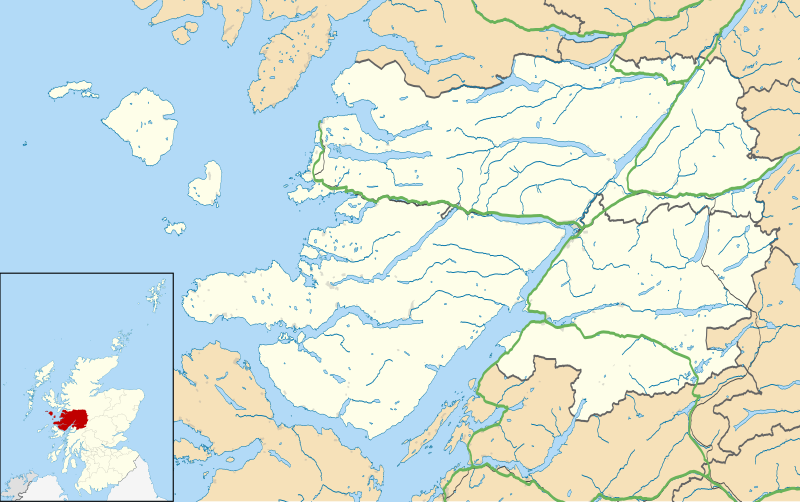
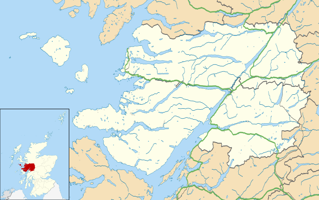
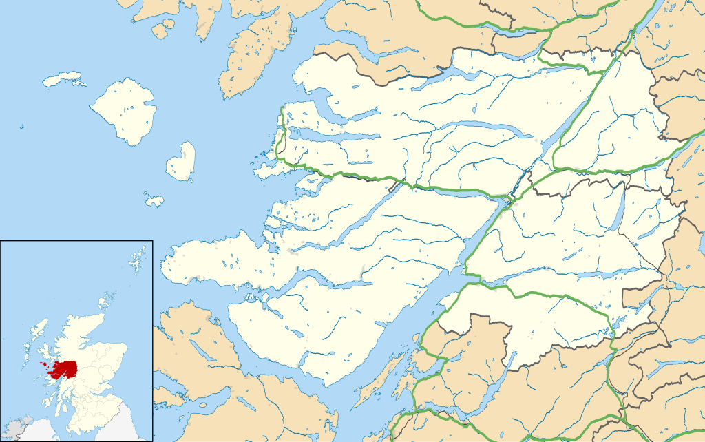
Map of the Lochaber ward management area, UK in 2011, with the following information shown:
Equirectangular map projection on WGS 84 datum, with N/S stretched 180% Geographic limits:
|
| ದಿನಾಂಕ | |
| ಆಕರ |
|
| ಕರ್ತೃ | Nilfanion, created using Ordnance Survey data |
| ಅನುಮತಿ (ಈ ಕಡತವನ್ನು ಮರುಬಳಕೆ ಮಾಡಲಾಗುತ್ತಿದೆ) |
ಈ ಕಡತ ಕ್ರಿಯೇಟಿವ್ ಕಾಮನ್ಸ್ Attribution
-Share Alike 3.0 Unported ಪರವಾನಗಿ ಹೊಂದಿದೆ. ವೈಶಿಷ್ಟ್ಯ: Contains Ordnance Survey data © Crown copyright and database right
|
| ಇತರೆ ಆವೃತ್ತಿಗಳು | File:Lochaber UK blank map.svg - Blank map |
ಕಡತದ ಇತಿಹಾಸ
ದಿನ/ಕಾಲ ಒತ್ತಿದರೆ ಆ ಸಮಯದಲ್ಲಿ ಈ ಕಡತದ ವಸ್ತುಸ್ಥಿತಿ ತೋರುತ್ತದೆ.
| ದಿನ/ಕಾಲ | ಕಿರುನೋಟ | ಆಯಾಮಗಳು | ಬಳಕೆದಾರ | ಟಿಪ್ಪಣಿ | |
|---|---|---|---|---|---|
| ಪ್ರಸಕ್ತ | ೧೯:೫೩, ೧೩ ಫೆಬ್ರವರಿ ೨೦೧೧ | | ೧,೪೨೫ × ೮೯೩ (೨.೩೯ MB) | Nilfanion | {{Information |Description=Map of the Lochaber ward management area, UK in 2011, with the following information shown: *Ward boundaries *Coastline, lakes and rivers *Roads and railways *Urban areas Equirectangular map projection on WGS 84 |
ಕಡತ ಬಳಕೆ
ಈ ಕೆಳಗಿನ ಪುಟವು ಈ ಚಿತ್ರಕ್ಕೆ ಸಂಪರ್ಕ ಹೊಂದಿದೆ:
ಜಾಗತಿಕ ಕಡತ ಉಪಯೋಗ
ಈ ಕಡತವನ್ನು ಕೆಳಗಿನ ಬೇರೆ ವಿಕಿಗಳೂ ಉಪಯೋಗಿಸುತ್ತಿವೆ:
- ar.wikipedia.org ಮೇಲೆ ಬಳಕೆ
- ceb.wikipedia.org ಮೇಲೆ ಬಳಕೆ
- cs.wikipedia.org ಮೇಲೆ ಬಳಕೆ
- en.wikipedia.org ಮೇಲೆ ಬಳಕೆ
- Fort William, Scotland
- Back of Keppoch
- Glencoe, Highland
- Kinlochleven
- Mallaig
- Kilchoan
- Ballachulish
- Glenfinnan
- Onich
- Arisaig
- Morar
- Achnacarry
- Inverie
- Acharacle
- Achintee, Fort William
- Achosnich
- Achriabhach
- Portuairk
- Glenuig
- Laggan, Great Glen
- Morvern
- Banavie
- Lochailort
- Caol
- Aberchalder
- Achaphubuil
- Tarbet, Loch Nevis
- Glenborrodale
- Kilmory, Ardnamurchan
- Invergarry
- Blaich
- Achindarroch
- Alisary
- Ardery
- Ardmolich
- Ardtoe
- Bohuntine
- Bonnavoulin
- Ockle
- Bracora
- Bracorina
- Sanna, Ardnamurchan
- Belford Hospital
- Resipole
- Lochaline
- Roshven
- Achnasaul
ಈ ಫೈಲ್ನ ಹೆಚ್ಚು ಜಾಗತಿಕ ಬಳಕೆಯನ್ನು ವೀಕ್ಷಿಸಿ.