ಚಿತ್ರ:Location map United Kingdom City of Preston.svg

Size of this PNG preview of this SVG file: ೫೪೫ × ೫೯೯ ಪಿಕ್ಸೆಲ್ಗಳು. ಇತರ ರೆಸಲ್ಯೂಶನ್ಗಳು: ೨೧೮ × ೨೪೦ ಪಿಕ್ಸೆಲ್ಗಳು | ೪೩೭ × ೪೮೦ ಪಿಕ್ಸೆಲ್ಗಳು | ೬೯೯ × ೭೬೮ ಪಿಕ್ಸೆಲ್ಗಳು | ೯೩೧ × ೧,೦೨೪ ಪಿಕ್ಸೆಲ್ಗಳು | ೧,೮೬೩ × ೨,೦೪೮ ಪಿಕ್ಸೆಲ್ಗಳು | ೧,೧೮೭ × ೧,೩೦೫ ಪಿಕ್ಸೆಲ್ಗಳು.
ಮೂಲ ಕಡತ (SVG ಫೈಲು, ಸುಮಾರಾಗಿ ೧,೧೮೭ × ೧,೩೦೫ ಚಿತ್ರಬಿಂದುಗಳು, ಫೈಲಿನ ಗಾತ್ರ: ೪.೨೭ MB)
ಈ ಫೈಲು ವಿಕಿಮೀಡಿಯ ಕಾಮನ್ಸ್ನಲ್ಲಿ ಇರುವುದು. ಅಲ್ಲಿನ ವಿವರಣೆ ಪುಟವನ್ನೇ ಕೆಳಗೆ ತೋರಿಸಲಾಗಿದೆ. ಕಾಮನ್ಸ್ ಕೃತಿಸ್ವಾಮ್ಯತೆಯಿಂದ ಮುಕ್ತ ಫೈಲುಗಳ ಒಂದು ಆಗರ. ಅಲ್ಲಿ ನೀವೂ ಸಹಕರಿಸಬಹುದು. |
ಸಾರಾಂಶ
| ವಿವರ |
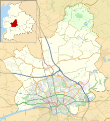
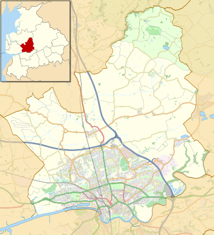
English: Map of the City of Preston district, Lancashire, England
Part of the Forest of Bowland Area of Outstanding Natural Beauty
Equirectangular map projection on WGS 84 datum, with N/S stretched 165% Geographic limits:
|
| ದಿನಾಂಕ | Original version 2014-07-22 22:19 (UTC), updated 2018-04-07. |
| ಆಕರ |
This file was derived from: |
| ಕರ್ತೃ |
|

.svg)
ಪರವಾನಗಿ
| This work contains information from OpenStreetMap, which is made available under the Open Database License (ODbL).
The ODbL does not require any particular license for maps produced from ODbL data. Prior to 1 August 2020, map tiles produced by the OpenStreetMap Foundation were licensed under the CC-BY-SA-2.0 license. Maps produced by other people may be subject to other licences. |
This file is licensed under the Creative Commons Attribution-Share Alike 2.0 Generic license.
ವೈಶಿಷ್ಟ್ಯ: © OpenStreetMap contributors. © Natural England copyright 2012. Contains Ordnance Survey data © Crown copyright and database right 2012.
- ನೀವು ಮುಕ್ತ:
- ಹಂಚಿಕೆಗೆ – ಕೆಲಸವನ್ನು ನಕಲು ಮಾಡಲು, ವಿತರಣೆ ಮತ್ತು ಸಾಗಿಸಲು
- ರೀಮಿಕ್ಸ್ ಮಾಡಲು – ಕೆಲಸವನ್ನು ಬಳಸಿಕೊಳ್ಳಲು
- ಈ ಕೆಳಗಿನ ಷರತ್ತುಗಳಲ್ಲಿ:
- ವೈಶಿಷ್ಟ್ಯ – ನೀವು ಸೂಕ್ತವಾದ ಕ್ರೆಡಿಟ್ ನೀಡಬೇಕು, ಪರವಾನಗಿಗೆ ಲಿಂಕ್ ಅನ್ನು ಒದಗಿಸಬೇಕು ಮತ್ತು ಯಾವುದೇ ಬದಲಾವಣೆಗಳನ್ನು ಮಾಡಿದ್ದರೆ ಸೂಚಿಸಬೇಕು. ನೀವು ಯಾವುದೇ ಸಮಂಜಸವಾದ ರೀತಿಯಲ್ಲಿ ಮಾಡಬಹುದು, ಆದರೆ ಪರವಾನಗಿದಾರರು ನಿಮ್ಮನ್ನು ಅಥವಾ ನಿಮ್ಮ ಯಾವುದೇ ಬಳಕೆಯನ್ನು ಅನುಮೋದಿಸಿದಂತೆ ರೀತಿಯಲ್ಲಿ ಉಪಯೋಗಿಸಬಾರದು.
- ಇರುವುದರಂತೆಯೇ ಹಂಚು – ನೀವು ರೀಮಿಕ್ಸ್ ಮಾಡಿದರೆ, ರೂಪಾಂತರಗೊಳಿಸಿದರೆ ಅಥವಾ ವಸ್ತುವಿನ ಮೇಲೆ ನಿರ್ಮಿಸಿದರೆ, ನಿಮ್ಮ ಕೊಡುಗೆಗಳನ್ನು ನೀವು ಮೂಲದಂತೆ ಅದೇ ಅಥವಾ ಹೊಂದಾಣಿಕೆಯ ಪರವಾನಗಿ ಅಡಿಯಲ್ಲಿ ವಿತರಿಸಬೇಕು.
Original upload log
This image is a derivative work of the following images:
- File:Preston_UK_ward_map_2010_(blank).svg licensed with Cc-by-sa-3.0
- 2011-04-24T22:48:11Z Nilfanion 1187x1305 (329725 Bytes) {{Information |Description=Map of Preston, Lancashire, UK with electoral wards shown. Equirectangular map projection on WGS 84 datum, with N/S stretched 165% Geographic limits: *West: 2.83W *East: 2.59W *North: 53.90N *Sout
Uploaded with derivativeFX
ಕಡತದ ಇತಿಹಾಸ
ದಿನ/ಕಾಲ ಒತ್ತಿದರೆ ಆ ಸಮಯದಲ್ಲಿ ಈ ಕಡತದ ವಸ್ತುಸ್ಥಿತಿ ತೋರುತ್ತದೆ.
| ದಿನ/ಕಾಲ | ಕಿರುನೋಟ | ಆಯಾಮಗಳು | ಬಳಕೆದಾರ | ಟಿಪ್ಪಣಿ | |
|---|---|---|---|---|---|
| ಪ್ರಸಕ್ತ | ೦೦:೩೪, ೮ ಏಪ್ರಿಲ್ ೨೦೧೮ | | ೧,೧೮೭ × ೧,೩೦೫ (೪.೨೭ MB) | Dr Greg | Added Broughton bypass; adjusted some road colours for clarity |
| ೦೨:೫೯, ೨೩ ಜುಲೈ ೨೦೧೪ |  | ೧,೧೮೭ × ೧,೩೦೫ (೮.೩೩ MB) | Dr Greg | Add Forest of Bowland; remove some unnecessary details | |
| ೦೨:೩೧, ೧೬ ಫೆಬ್ರವರಿ ೨೦೧೩ |  | ೧,೧೮೭ × ೧,೩೦೫ (೮.೭೭ MB) | Dr Greg | == {{int:filedesc}} == {{Information |Description= {{en|Map of Preston, Lancashire, UK with electoral wards shown. Equirectangular map projection on WGS 84 datum, with N/S stretched 165% Geographic limits: *West: 2.83W *East: 2.59W *North: 53.... |
ಕಡತ ಬಳಕೆ
ಈ ಕೆಳಗಿನ ಪುಟವು ಈ ಚಿತ್ರಕ್ಕೆ ಸಂಪರ್ಕ ಹೊಂದಿದೆ:
ಜಾಗತಿಕ ಕಡತ ಉಪಯೋಗ
ಈ ಕಡತವನ್ನು ಕೆಳಗಿನ ಬೇರೆ ವಿಕಿಗಳೂ ಉಪಯೋಗಿಸುತ್ತಿವೆ:
- ar.wikipedia.org ಮೇಲೆ ಬಳಕೆ
- azb.wikipedia.org ಮೇಲೆ ಬಳಕೆ
- ceb.wikipedia.org ಮೇಲೆ ಬಳಕೆ
- en.wikipedia.org ಮೇಲೆ ಬಳಕೆ
- Preston, Lancashire
- Catforth
- Goosnargh
- Grimsargh
- Barton, Preston
- Fulwood, Lancashire
- Woodplumpton
- Broughton, Lancashire
- Chingle Hall
- Lea, Lancashire
- Grimsargh railway station
- Whittingham, Lancashire
- Beacon Fell, Lancashire
- Inglewhite
- User:Dr Greg/Sandpit3
- RAF Barton Hall
- Haighton
- Whittingham Hospital
- Eaves, Lancashire
- Whitechapel, Lancashire
- Ingol
- HM Prison Preston
- Transport in Preston
- City of Preston, Lancashire
- Talk:City of Preston, Lancashire
- St Anne's Church, Woodplumpton
- St Mary's Church, Goosnargh
- St Michael's Church, Grimsargh
- St John the Baptist's Church, Broughton
- Module:Location map/data/United Kingdom City of Preston/doc
- Ye Horns Inn
- St Lawrence's Church, Barton
- St Mary's Church, Fernyhalgh
- Module:Location map/data/United Kingdom City of Preston
- The Plough at Eaves
- The Green Man at Inglewhite
- Barton and Broughton railway station
- Broughton railway station (England)
- fa.wikipedia.org ಮೇಲೆ ಬಳಕೆ
- ja.wikipedia.org ಮೇಲೆ ಬಳಕೆ
- si.wikipedia.org ಮೇಲೆ ಬಳಕೆ
- tr.wikipedia.org ಮೇಲೆ ಬಳಕೆ
ಈ ಫೈಲ್ನ ಹೆಚ್ಚು ಜಾಗತಿಕ ಬಳಕೆಯನ್ನು ವೀಕ್ಷಿಸಿ.