ಚಿತ್ರ:Kuala Lumpur locator map.svg

Size of this PNG preview of this SVG file: ೪೨೮ × ೫೯೯ ಪಿಕ್ಸೆಲ್ಗಳು. ಇತರ ರೆಸಲ್ಯೂಶನ್ಗಳು: ೧೭೧ × ೨೪೦ ಪಿಕ್ಸೆಲ್ಗಳು | ೩೪೩ × ೪೮೦ ಪಿಕ್ಸೆಲ್ಗಳು | ೫೪೮ × ೭೬೮ ಪಿಕ್ಸೆಲ್ಗಳು | ೭೩೧ × ೧,೦೨೪ ಪಿಕ್ಸೆಲ್ಗಳು | ೧,೪೬೩ × ೨,೦೪೮ ಪಿಕ್ಸೆಲ್ಗಳು | ೫೦೦ × ೭೦೦ ಪಿಕ್ಸೆಲ್ಗಳು.
ಮೂಲ ಕಡತ (SVG ಫೈಲು, ಸುಮಾರಾಗಿ ೫೦೦ × ೭೦೦ ಚಿತ್ರಬಿಂದುಗಳು, ಫೈಲಿನ ಗಾತ್ರ: ೩೦೬ KB)
ಈ ಫೈಲು ವಿಕಿಮೀಡಿಯ ಕಾಮನ್ಸ್ನಲ್ಲಿ ಇರುವುದು. ಅಲ್ಲಿನ ವಿವರಣೆ ಪುಟವನ್ನೇ ಕೆಳಗೆ ತೋರಿಸಲಾಗಿದೆ. ಕಾಮನ್ಸ್ ಕೃತಿಸ್ವಾಮ್ಯತೆಯಿಂದ ಮುಕ್ತ ಫೈಲುಗಳ ಒಂದು ಆಗರ. ಅಲ್ಲಿ ನೀವೂ ಸಹಕರಿಸಬಹುದು. |
ಸಾರಾಂಶ
| ವಿವರ |
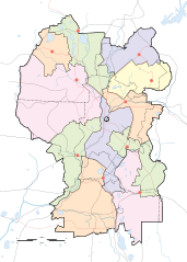
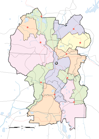
English: Map of w:Kuala Lumpur divided according to constituencies with highways (black) and major roads (red). City centre is marked by a Star Button and constituency towns marked by Red Buttons. Mukims (communes) are marked with dotted lines. |
||
| ದಿನಾಂಕ | |||
| ಆಕರ |
Own work by uploader for w:Wikipedia:WikiProject Malaysia/Cartography New boundaries were from SPR Malaysia and Tindak Malaysia (2018) |
||
| ಕರ್ತೃ |
|
||
| ಇತರೆ ಆವೃತ್ತಿಗಳು | File:Kuala Lumpur subdistrict locator map.svg |
ಪರವಾನಗಿ
I, the copyright holder of this work, hereby publish it under the following license:
This file is licensed under the Creative Commons Attribution-Share Alike 4.0 International license.
- ನೀವು ಮುಕ್ತ:
- ಹಂಚಿಕೆಗೆ – ಕೆಲಸವನ್ನು ನಕಲು ಮಾಡಲು, ವಿತರಣೆ ಮತ್ತು ಸಾಗಿಸಲು
- ರೀಮಿಕ್ಸ್ ಮಾಡಲು – ಕೆಲಸವನ್ನು ಬಳಸಿಕೊಳ್ಳಲು
- ಈ ಕೆಳಗಿನ ಷರತ್ತುಗಳಲ್ಲಿ:
- ವೈಶಿಷ್ಟ್ಯ – ನೀವು ಸೂಕ್ತವಾದ ಕ್ರೆಡಿಟ್ ನೀಡಬೇಕು, ಪರವಾನಗಿಗೆ ಲಿಂಕ್ ಅನ್ನು ಒದಗಿಸಬೇಕು ಮತ್ತು ಯಾವುದೇ ಬದಲಾವಣೆಗಳನ್ನು ಮಾಡಿದ್ದರೆ ಸೂಚಿಸಬೇಕು. ನೀವು ಯಾವುದೇ ಸಮಂಜಸವಾದ ರೀತಿಯಲ್ಲಿ ಮಾಡಬಹುದು, ಆದರೆ ಪರವಾನಗಿದಾರರು ನಿಮ್ಮನ್ನು ಅಥವಾ ನಿಮ್ಮ ಯಾವುದೇ ಬಳಕೆಯನ್ನು ಅನುಮೋದಿಸಿದಂತೆ ರೀತಿಯಲ್ಲಿ ಉಪಯೋಗಿಸಬಾರದು.
- ಇರುವುದರಂತೆಯೇ ಹಂಚು – ನೀವು ರೀಮಿಕ್ಸ್ ಮಾಡಿದರೆ, ರೂಪಾಂತರಗೊಳಿಸಿದರೆ ಅಥವಾ ವಸ್ತುವಿನ ಮೇಲೆ ನಿರ್ಮಿಸಿದರೆ, ನಿಮ್ಮ ಕೊಡುಗೆಗಳನ್ನು ನೀವು ಮೂಲದಂತೆ ಅದೇ ಅಥವಾ ಹೊಂದಾಣಿಕೆಯ ಪರವಾನಗಿ ಅಡಿಯಲ್ಲಿ ವಿತರಿಸಬೇಕು.
ಕಡತದ ಇತಿಹಾಸ
ದಿನ/ಕಾಲ ಒತ್ತಿದರೆ ಆ ಸಮಯದಲ್ಲಿ ಈ ಕಡತದ ವಸ್ತುಸ್ಥಿತಿ ತೋರುತ್ತದೆ.
| ದಿನ/ಕಾಲ | ಕಿರುನೋಟ | ಆಯಾಮಗಳು | ಬಳಕೆದಾರ | ಟಿಪ್ಪಣಿ | |
|---|---|---|---|---|---|
| ಪ್ರಸಕ್ತ | ೦೧:೨೦, ೩೦ ಏಪ್ರಿಲ್ ೨೦೨೦ | | ೫೦೦ × ೭೦೦ (೩೦೬ KB) | *angys* | add mukim boundaries |
| ೦೦:೪೮, ೩೦ ಏಪ್ರಿಲ್ ೨೦೨೦ |  | ೫೦೦ × ೭೦೦ (೨೯೩ KB) | *angys* | Refined boundary, many thanks to Tindak Malaysia | |
| ೨೩:೩೦, ೧೦ ಸೆಪ್ಟೆಂಬರ್ ೨೦೧೮ |  | ೫೦೦ × ೭೦೦ (೩೭೯ KB) | *angys* | new seat boundary from File:Selangor WPKL PRU14.svg | |
| ೧೭:೨೬, ೨೨ ಜೂನ್ ೨೦೦೯ |  | ೫೦೦ × ೭೦೦ (೩೦೭ KB) | Mdzafri | {{Information |Description={{en|1=Map of w:Kuala Lumpur divided according to constituencies with highways (black) and major roads (red). City centre is marked by a Star Button and constituency towns marked by Red Buttons.}} |Source=Own work by uploade |
ಕಡತ ಬಳಕೆ
ಈ ಕೆಳಗಿನ ಪುಟವು ಈ ಚಿತ್ರಕ್ಕೆ ಸಂಪರ್ಕ ಹೊಂದಿದೆ:
ಜಾಗತಿಕ ಕಡತ ಉಪಯೋಗ
ಈ ಕಡತವನ್ನು ಕೆಳಗಿನ ಬೇರೆ ವಿಕಿಗಳೂ ಉಪಯೋಗಿಸುತ್ತಿವೆ:
- ar.wikipedia.org ಮೇಲೆ ಬಳಕೆ
- bjn.wikipedia.org ಮೇಲೆ ಬಳಕೆ
- ceb.wikipedia.org ಮೇಲೆ ಬಳಕೆ
- en.wikipedia.org ಮೇಲೆ ಬಳಕೆ
- Bangsar
- Taman Tun Dr Ismail
- RMAF Kuala Lumpur Air Base
- Wangsa Maju
- Islamic Arts Museum Malaysia
- User:Mdzafri
- Module:Location map/data/Malaysia Kuala Lumpur/doc
- Abdul Rahman Auf Mosque
- Kuala Lumpur Hospital
- Wikipedia:Meetup/Kuala Lumpur
- The Boulevard Hotel Kuala Lumpur
- Module:Location map/data/Malaysia Kuala Lumpur
- Wikipedia:Graphics Lab/Map workshop/Archive/Jun 2018
- 2019 Malaysia M3 League
- 2020 Malaysia M3 League
- Wikipedia:Graphics Lab/Map workshop/Archive/Feb 2020
- fa.wikipedia.org ಮೇಲೆ ಬಳಕೆ
- fr.wikipedia.org ಮೇಲೆ ಬಳಕೆ
- he.wikipedia.org ಮೇಲೆ ಬಳಕೆ
- id.wikipedia.org ಮೇಲೆ ಬಳಕೆ
- jv.wikipedia.org ಮೇಲೆ ಬಳಕೆ
- ms.wikipedia.org ಮೇಲೆ ಬಳಕೆ
- mt.wikipedia.org ಮೇಲೆ ಬಳಕೆ
- pl.wikipedia.org ಮೇಲೆ ಬಳಕೆ
ಈ ಫೈಲ್ನ ಹೆಚ್ಚು ಜಾಗತಿಕ ಬಳಕೆಯನ್ನು ವೀಕ್ಷಿಸಿ.