ಚಿತ್ರ:Japan natural location map with side map of the Ryukyu Islands.jpg

ಈ ಮುನ್ನೋಟ ಗಾತ್ರ:೬೬೪ × ೬೦೦ ಪಿಕ್ಸೆಲ್ಗಳು. ಇತರ ರೆಸಲ್ಯೂಶನ್ಗಳು: ೨೬೬ × ೨೪೦ ಪಿಕ್ಸೆಲ್ಗಳು | ೫೩೧ × ೪೮೦ ಪಿಕ್ಸೆಲ್ಗಳು | ೮೫೦ × ೭೬೮ ಪಿಕ್ಸೆಲ್ಗಳು | ೧,೧೩೩ × ೧,೦೨೪ ಪಿಕ್ಸೆಲ್ಗಳು | ೨,೪೯೭ × ೨,೨೫೬ ಪಿಕ್ಸೆಲ್ಗಳು.
ಮೂಲ ಕಡತ (೨,೪೯೭ × ೨,೨೫೬ ಚಿತ್ರಬಿಂದು, ಫೈಲಿನ ಗಾತ್ರ: ೮೩೦ KB, MIME ಪ್ರಕಾರ: image/jpeg)
ಈ ಫೈಲು ವಿಕಿಮೀಡಿಯ ಕಾಮನ್ಸ್ನಲ್ಲಿ ಇರುವುದು. ಅಲ್ಲಿನ ವಿವರಣೆ ಪುಟವನ್ನೇ ಕೆಳಗೆ ತೋರಿಸಲಾಗಿದೆ. ಕಾಮನ್ಸ್ ಕೃತಿಸ್ವಾಮ್ಯತೆಯಿಂದ ಮುಕ್ತ ಫೈಲುಗಳ ಒಂದು ಆಗರ. ಅಲ್ಲಿ ನೀವೂ ಸಹಕರಿಸಬಹುದು. |
ಸಾರಾಂಶ
| ವಿವರ |
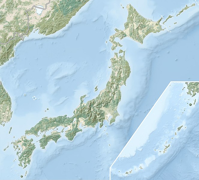
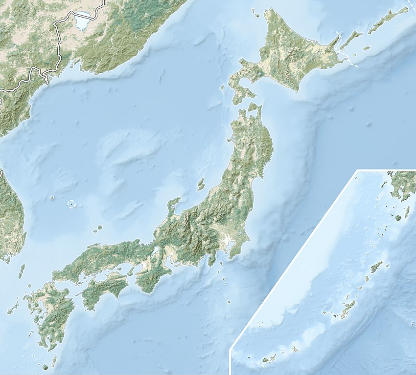
English: Natural Location map of Japan
Equirectangular projection. Geographic limits to locate objects in the main map with the main islands:
Geographic limits to locate objects in the side map with the Ryukyu Islands:
|
||
| ದಿನಾಂಕ | |||
| ಆಕರ |
|
||
| ಕರ್ತೃ | Alexrk2 | ||
| ಅನುಮತಿ (ಈ ಕಡತವನ್ನು ಮರುಬಳಕೆ ಮಾಡಲಾಗುತ್ತಿದೆ) |
ಈ ಕಡತ ಕ್ರಿಯೇಟಿವ್ ಕಾಮನ್ಸ್ Attribution
-Share Alike 3.0 Unported ಪರವಾನಗಿ ಹೊಂದಿದೆ.
|
||
| ಇತರೆ ಆವೃತ್ತಿಗಳು |
|


ಕಡತದ ಇತಿಹಾಸ
ದಿನ/ಕಾಲ ಒತ್ತಿದರೆ ಆ ಸಮಯದಲ್ಲಿ ಈ ಕಡತದ ವಸ್ತುಸ್ಥಿತಿ ತೋರುತ್ತದೆ.
| ದಿನ/ಕಾಲ | ಕಿರುನೋಟ | ಆಯಾಮಗಳು | ಬಳಕೆದಾರ | ಟಿಪ್ಪಣಿ | |
|---|---|---|---|---|---|
| ಪ್ರಸಕ್ತ | ೦೩:೧೧, ೧೦ ಮಾರ್ಚ್ ೨೦೨೨ | | ೨,೪೯೭ × ೨,೨೫೬ (೮೩೦ KB) | Sting | Natural Earth land cover data for Ryukyu Islands |
| ೧೫:೧೪, ೨೨ ಜೂನ್ ೨೦೧೮ |  | ೨,೪೯೭ × ೨,೨೫೬ (೭೯೪ KB) | Mardetanha | Reverted to version as of 19:56, 22 March 2011 (UTC) | |
| ೦೧:೨೬, ೨೩ ಮಾರ್ಚ್ ೨೦೧೧ |  | ೨,೪೯೭ × ೨,೨೫೬ (೭೯೪ KB) | Alexrk2 | RGB | |
| ೦೦:೩೭, ೨೩ ಮಾರ್ಚ್ ೨೦೧೧ |  | ೨,೪೯೭ × ೨,೨೫೬ (೭೪೫ KB) | Chumwa | RGB mode | |
| ೦೨:೩೮, ೨೨ ಮಾರ್ಚ್ ೨೦೧೧ |  | ೨,೪೯೭ × ೨,೨೫೬ (೧.೫೪ MB) | Alexrk2 | == {{int:filedesc}} == {{Information |Description= {{en|Natural Location map of Japan Equirectangular projection. Geographic limits to locate objects in the main map with the main islands: * N: 45°51'37" N (45.86°N) * S: 30°01'13" N (30. |
ಕಡತ ಬಳಕೆ
ಈ ಕೆಳಗಿನ ಪುಟವು ಈ ಚಿತ್ರಕ್ಕೆ ಸಂಪರ್ಕ ಹೊಂದಿದೆ:
ಜಾಗತಿಕ ಕಡತ ಉಪಯೋಗ
ಈ ಕಡತವನ್ನು ಕೆಳಗಿನ ಬೇರೆ ವಿಕಿಗಳೂ ಉಪಯೋಗಿಸುತ್ತಿವೆ:
- ace.wikipedia.org ಮೇಲೆ ಬಳಕೆ
- als.wikipedia.org ಮೇಲೆ ಬಳಕೆ
- ar.wikipedia.org ಮೇಲೆ ಬಳಕೆ
- arz.wikipedia.org ಮೇಲೆ ಬಳಕೆ
- ast.wikipedia.org ಮೇಲೆ ಬಳಕೆ
- as.wikipedia.org ಮೇಲೆ ಬಳಕೆ
- azb.wikipedia.org ಮೇಲೆ ಬಳಕೆ
- az.wikipedia.org ಮೇಲೆ ಬಳಕೆ
- Hokkaydo
- Kyuşu
- Fuci
- Honşu
- İtsukuşima
- Asama dağı
- Şablon:Yer xəritəsi Yaponiya
- Tohoku zəlzələsi və sunamisi (2011)
- Fukuşima-1 AES
- Böyük Hanşin zəlzələsi
- Böyük Kanto zəlzələsi
- Hoey zəlzələsi
- Mino-Ovari zəlzələsi (1891)
- Yapon çökəkliyi
- Ryukyu adaları
- Osumi boğazı
- Sanqar boğazı
- Koreya boğazı
- Tsuşima boğazı
- Harim dənizi
- Yatsuşiro dənizi
- Hiuqa dənizi
- Daxili Yapon dənizi
- Atsumi yarımadası
- Naqasaki yarımadası
- İzu yarımadası
- Simabara yarımadası
- Şiretoko yarımadası
- Nosuke yarımadası
ಈ ಫೈಲ್ನ ಹೆಚ್ಚು ಜಾಗತಿಕ ಬಳಕೆಯನ್ನು ವೀಕ್ಷಿಸಿ.