ಚಿತ್ರ:Israel location map with stripes.svg

Size of this PNG preview of this SVG file: ೩೨೨ × ೫೯೮ ಪಿಕ್ಸೆಲ್ಗಳು. ಇತರ ರೆಸಲ್ಯೂಶನ್ಗಳು: ೧೨೯ × ೨೪೦ ಪಿಕ್ಸೆಲ್ಗಳು | ೨೫೮ × ೪೮೦ ಪಿಕ್ಸೆಲ್ಗಳು | ೪೧೩ × ೭೬೮ ಪಿಕ್ಸೆಲ್ಗಳು | ೫೫೧ × ೧,೦೨೪ ಪಿಕ್ಸೆಲ್ಗಳು | ೧,೧೦೨ × ೨,೦೪೮ ಪಿಕ್ಸೆಲ್ಗಳು | ೬೧೪ × ೧,೧೪೧ ಪಿಕ್ಸೆಲ್ಗಳು.
ಮೂಲ ಕಡತ (SVG ಫೈಲು, ಸುಮಾರಾಗಿ ೬೧೪ × ೧,೧೪೧ ಚಿತ್ರಬಿಂದುಗಳು, ಫೈಲಿನ ಗಾತ್ರ: ೧೭೦ KB)
ಈ ಫೈಲು ವಿಕಿಮೀಡಿಯ ಕಾಮನ್ಸ್ನಲ್ಲಿ ಇರುವುದು. ಅಲ್ಲಿನ ವಿವರಣೆ ಪುಟವನ್ನೇ ಕೆಳಗೆ ತೋರಿಸಲಾಗಿದೆ. ಕಾಮನ್ಸ್ ಕೃತಿಸ್ವಾಮ್ಯತೆಯಿಂದ ಮುಕ್ತ ಫೈಲುಗಳ ಒಂದು ಆಗರ. ಅಲ್ಲಿ ನೀವೂ ಸಹಕರಿಸಬಹುದು. |
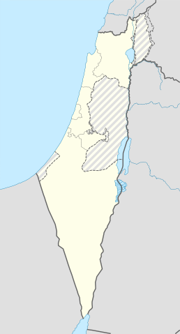
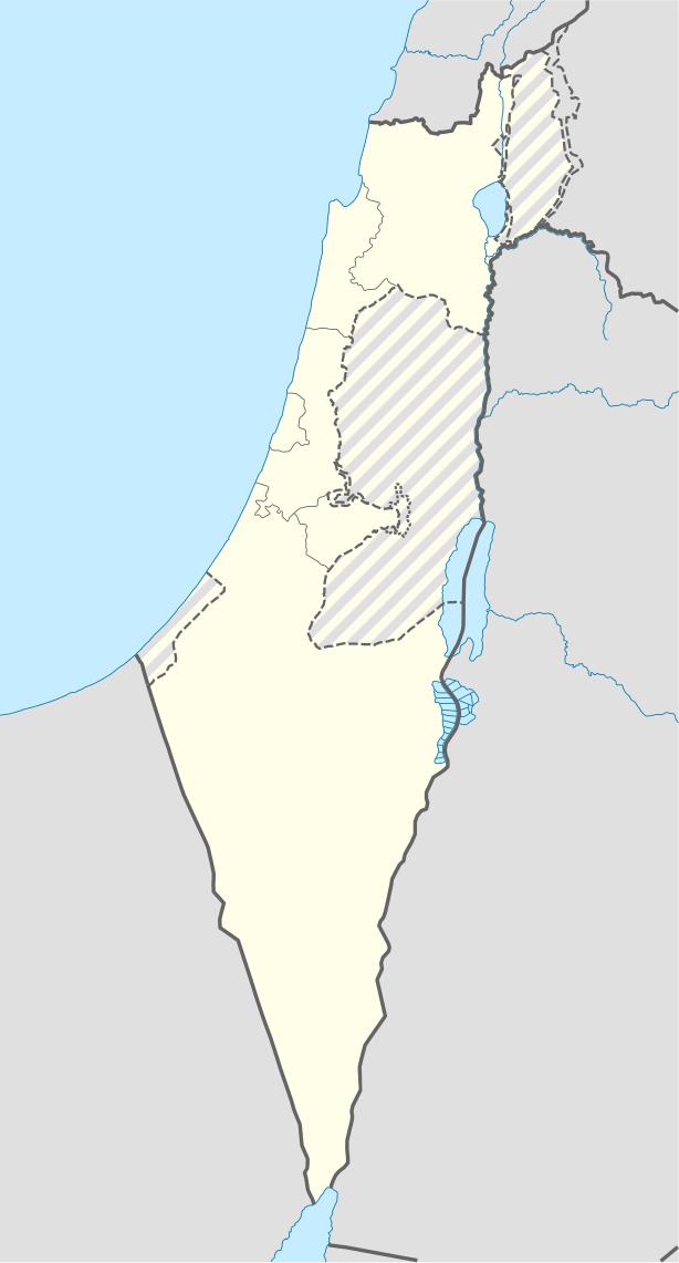
| ವಿವರ | Location map of Israel, with the Israeli-occupied Palestinian territories of the West Bank and the Gaza Strip and the Syrian Golan Heights grey stripes. | ||
| ದಿನಾಂಕ | |||
| ಆಕರ | Own work based on: Israel location map.svg by NordNordWest | ||
| ಕರ್ತೃ | Jackmcbarn | ||
| ಅನುಮತಿ (ಈ ಕಡತವನ್ನು ಮರುಬಳಕೆ ಮಾಡಲಾಗುತ್ತಿದೆ) |
I, the copyright holder of this work, hereby publish it under the following licenses:
ಈ ಕಡತ ಕ್ರಿಯೇಟಿವ್ ಕಾಮನ್ಸ್ Attribution
-Share Alike 3.0 Unported ಪರವಾನಗಿ ಹೊಂದಿದೆ.
ನಿಮ್ಮಿಚ್ಛೆಯ ಪರವಾನಗಿಯನ್ನು ನೀವು ಆರಿಸಿಕೊಳ್ಳಬಹುದು. |
||
| SVG genesis | This locator map was created with unknown tool. |

ಕಡತದ ಇತಿಹಾಸ
ದಿನ/ಕಾಲ ಒತ್ತಿದರೆ ಆ ಸಮಯದಲ್ಲಿ ಈ ಕಡತದ ವಸ್ತುಸ್ಥಿತಿ ತೋರುತ್ತದೆ.
| ದಿನ/ಕಾಲ | ಕಿರುನೋಟ | ಆಯಾಮಗಳು | ಬಳಕೆದಾರ | ಟಿಪ್ಪಣಿ | |
|---|---|---|---|---|---|
| ಪ್ರಸಕ್ತ | ೨೦:೧೩, ೧೬ ಜೂನ್ ೨೦೧೮ | | ೬೧೪ × ೧,೧೪೧ (೧೭೦ KB) | Jdx | Reverted to version as of 10:35, 16 June 2018 (UTC) |
| ೧೯:೩೪, ೧೬ ಜೂನ್ ೨೦೧೮ |  | ೫೦೪ × ೯೩೬ (೧೭೦ KB) | Beebbeebe | Reverted to version as of 00:40, 16 June 2018 (UTC) don't revert without stating a reason | |
| ೧೬:೦೫, ೧೬ ಜೂನ್ ೨೦೧೮ |  | ೬೧೪ × ೧,೧೪೧ (೧೭೦ KB) | Denniss | Reverted to version as of 04:28, 21 May 2018 (UTC) | |
| ೦೬:೧೦, ೧೬ ಜೂನ್ ೨೦೧೮ |  | ೫೦೪ × ೯೩೬ (೧೭೦ KB) | Beebbeebe | Reverted to version as of 19:23, 14 May 2018 (UTC) The current map is simply incorrect. And I don't want to upload a new one, I'll have to edit more than a hundred wiki-articles. | |
| ೦೯:೫೮, ೨೧ ಮೇ ೨೦೧೮ |  | ೬೧೪ × ೧,೧೪೧ (೧೭೦ KB) | Nableezy | Reverted to version as of 19:08, 18 September 2016 (UTC) actually go back to standard no green or blue lines | |
| ೨೩:೫೩, ೧೫ ಮೇ ೨೦೧೮ |  | ೬೧೪ × ೧,೧೪೧ (೧೭೪ KB) | Nableezy | Reverted to version as of 03:49, 14 May 2018 (UTC) | |
| ೦೦:೫೩, ೧೫ ಮೇ ೨೦೧೮ |  | ೫೦೪ × ೯೩೬ (೧೭೦ KB) | Eric's son | Reverted to version as of 13:42, 24 March 2018 (UTC) | |
| ೦೯:೧೯, ೧೪ ಮೇ ೨೦೧೮ |  | ೬೧೪ × ೧,೧೪೧ (೧೭೪ KB) | Nableezy | Reverted to version as of 06:09, 11 March 2018 (UTC) restore golan as occupied territory | |
| ೧೯:೧೨, ೨೪ ಮಾರ್ಚ್ ೨೦೧೮ |  | ೫೦೪ × ೯೩೬ (೧೭೦ KB) | Eric's son | Correcting color for border with Jordan | |
| ೧೮:೫೬, ೨೪ ಮಾರ್ಚ್ ೨೦೧೮ |  | ೫೦೪ × ೯೩೬ (೧೭೦ KB) | Eric's son | Fixed correct colors with vector |
ಕಡತ ಬಳಕೆ
ಈ ಕೆಳಗಿನ 14 ಪುಟಗಳು ಈ ಚಿತ್ರಕ್ಕೆ ಸಂಪರ್ಕ ಹೊಂದಿವೆ:
- ಟೆಂಪ್ಲೇಟು:Location map Israel Golan
- ಟೆಂಪ್ಲೇಟು:Location map Israel ashkelon
- ಟೆಂಪ್ಲೇಟು:Location map Israel binyamin
- ಟೆಂಪ್ಲೇಟು:Location map Israel center ta
- ಟೆಂಪ್ಲೇಟು:Location map Israel haifa
- ಟೆಂಪ್ಲೇಟು:Location map Israel jezreel
- ಟೆಂಪ್ಲೇಟು:Location map Israel negev mt
- ಟೆಂಪ್ಲೇಟು:Location map Israel north haifa
- ಟೆಂಪ್ಲೇಟು:Location map Israel north negev
- ಟೆಂಪ್ಲೇಟು:Location map Israel northeast
- ಟೆಂಪ್ಲೇಟು:Location map Israel northwest
- ಟೆಂಪ್ಲೇಟು:Location map Israel northwest negev
- ಟೆಂಪ್ಲೇಟು:Location map Israel shomron
- ಟೆಂಪ್ಲೇಟು:Location map Israel south wb
ಜಾಗತಿಕ ಕಡತ ಉಪಯೋಗ
ಈ ಕಡತವನ್ನು ಕೆಳಗಿನ ಬೇರೆ ವಿಕಿಗಳೂ ಉಪಯೋಗಿಸುತ್ತಿವೆ:
- af.wikipedia.org ಮೇಲೆ ಬಳಕೆ
- Rehovot
- Nasaret
- Eilat
- Dimona
- Ramla
- Safed
- Tiberias
- Lod
- Ben Gurion Internasionale Lughawe
- Hadera
- Gedera
- Givatayim
- Be'er Sheva
- Rishon LeZion
- Petah Tikva
- Ashdod
- Netanya
- Binyamina-Giv'at Ada
- Bnei Brak
- Holon
- Ramat Gan
- Ashkelon
- Bat Yam
- Beit Shemesh
- Kfar Saba
- Herzliya
- Modi'in-Maccabim-Re'ut
- Ra'anana
- Ramon-lughawe
- an.wikipedia.org ಮೇಲೆ ಬಳಕೆ
- ar.wikipedia.org ಮೇಲೆ ಬಳಕೆ
- القوات الجوية الإسرائيلية
- قلعة كوكب الهوا
- قالب:Location map Israel Golan
- قالب:Location map Israel ashkelon
- قالب:Location map Israel binyamin
- قالب:Location map Israel center ta
- قالب:Location map Israel haifa
- قالب:Location map Israel jezreel
- قالب:Location map Israel negev mt
- قالب:Location map Israel north haifa
- قالب:Location map Israel north negev
- قالب:Location map Israel northeast
- قالب:Location map Israel northwest
- قالب:Location map Israel northwest negev
- قالب:Location map Israel shomron
- قالب:Location map Israel south wb
- ثقافة كبارية
- مغارة كبارة
ಈ ಫೈಲ್ನ ಹೆಚ್ಚು ಜಾಗತಿಕ ಬಳಕೆಯನ್ನು ವೀಕ್ಷಿಸಿ.