ಚಿತ್ರ:Iran’s largely uninhabited Dasht-e Kavir, or Great Salt Desert.jpg

ಈ ಮುನ್ನೋಟ ಗಾತ್ರ:೬೦೦ × ೬೦೦ ಪಿಕ್ಸೆಲ್ಗಳು. ಇತರ ರೆಸಲ್ಯೂಶನ್ಗಳು: ೨೪೦ × ೨೪೦ ಪಿಕ್ಸೆಲ್ಗಳು | ೪೮೦ × ೪೮೦ ಪಿಕ್ಸೆಲ್ಗಳು | ೭೬೮ × ೭೬೮ ಪಿಕ್ಸೆಲ್ಗಳು | ೧,೦೨೪ × ೧,೦೨೪ ಪಿಕ್ಸೆಲ್ಗಳು | ೨,೦೪೮ × ೨,೦೪೮ ಪಿಕ್ಸೆಲ್ಗಳು | ೩,೬೪೮ × ೩,೬೪೮ ಪಿಕ್ಸೆಲ್ಗಳು.
ಮೂಲ ಕಡತ (೩,೬೪೮ × ೩,೬೪೮ ಚಿತ್ರಬಿಂದು, ಫೈಲಿನ ಗಾತ್ರ: ೧.೮೩ MB, MIME ಪ್ರಕಾರ: image/jpeg)
ಈ ಫೈಲು ವಿಕಿಮೀಡಿಯ ಕಾಮನ್ಸ್ನಲ್ಲಿ ಇರುವುದು. ಅಲ್ಲಿನ ವಿವರಣೆ ಪುಟವನ್ನೇ ಕೆಳಗೆ ತೋರಿಸಲಾಗಿದೆ. ಕಾಮನ್ಸ್ ಕೃತಿಸ್ವಾಮ್ಯತೆಯಿಂದ ಮುಕ್ತ ಫೈಲುಗಳ ಒಂದು ಆಗರ. ಅಲ್ಲಿ ನೀವೂ ಸಹಕರಿಸಬಹುದು. |
ಸಾರಾಂಶ
| ವಿವರ |
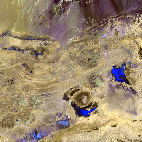
English: This image of Iran’s largely uninhabited Dasht-e Kavir, or Great Salt Desert was acquired by Landsat 7’s Enhanced Thematic Mapper plus sensor. |
| ದಿನಾಂಕ | (UTC) |
| ಆಕರ | http://www.nasa.gov/multimedia/imagegallery/image_feature_522.html |
| ಕರ್ತೃ | NASA/USGS |
| ಅನುಮತಿ (ಈ ಕಡತವನ್ನು ಮರುಬಳಕೆ ಮಾಡಲಾಗುತ್ತಿದೆ) |
U.S. Government work |
ಪರವಾನಗಿ
| This file is in the public domain in the United States because it was solely created by NASA. NASA copyright policy states that "NASA material is not protected by copyright unless noted". (See Template:PD-USGov, NASA copyright policy page or JPL Image Use Policy.) | ||
 |
Warnings:
|
Original upload log
The original description page was here. All following user names refer to en.wikipedia.
- 2009-10-09 21:03 Mattisse 3648×3648× (1915648 bytes) {{Information |Description = This image of Iran’s largely uninhabited Dasht-e Kavir, or Great Salt Desert was acquired by Landsat 7’s Enhanced Thematic Mapper plus sensor. |Source = http://www.nasa.gov/multimedia/imagegallery/image_feat
ಕಡತದ ಇತಿಹಾಸ
ದಿನ/ಕಾಲ ಒತ್ತಿದರೆ ಆ ಸಮಯದಲ್ಲಿ ಈ ಕಡತದ ವಸ್ತುಸ್ಥಿತಿ ತೋರುತ್ತದೆ.
| ದಿನ/ಕಾಲ | ಕಿರುನೋಟ | ಆಯಾಮಗಳು | ಬಳಕೆದಾರ | ಟಿಪ್ಪಣಿ | |
|---|---|---|---|---|---|
| ಪ್ರಸಕ್ತ | ೧೫:೫೯, ೧೧ ಡಿಸೆಂಬರ್ ೨೦೧೧ | | ೩,೬೪೮ × ೩,೬೪೮ (೧.೮೩ MB) | Urdangaray | {{Information |Description={{en|This image of Iran’s largely uninhabited Dasht-e Kavir, or Great Salt Desert was acquired by Landsat 7’s Enhanced Thematic Mapper plus sensor.}} |Source=Transferred from [http://en.wikipedia.org en.wikipedia]<br/> (Orig |
ಕಡತ ಬಳಕೆ
ಈ ಕೆಳಗಿನ ಪುಟವು ಈ ಚಿತ್ರಕ್ಕೆ ಸಂಪರ್ಕ ಹೊಂದಿದೆ:
ಜಾಗತಿಕ ಕಡತ ಉಪಯೋಗ
ಈ ಕಡತವನ್ನು ಕೆಳಗಿನ ಬೇರೆ ವಿಕಿಗಳೂ ಉಪಯೋಗಿಸುತ್ತಿವೆ:
- bs.wikipedia.org ಮೇಲೆ ಬಳಕೆ
- es.wikipedia.org ಮೇಲೆ ಬಳಕೆ
- fa.wikipedia.org ಮೇಲೆ ಬಳಕೆ
- hr.wikipedia.org ಮೇಲೆ ಬಳಕೆ
- sh.wikipedia.org ಮೇಲೆ ಬಳಕೆ
- sl.wikipedia.org ಮೇಲೆ ಬಳಕೆ