ಚಿತ್ರ:Europe EU laea location map.svg

Size of this PNG preview of this SVG file: ೭೦೧ × ೫೯೯ ಪಿಕ್ಸೆಲ್ಗಳು. ಇತರ ರೆಸಲ್ಯೂಶನ್ಗಳು: ೨೮೧ × ೨೪೦ ಪಿಕ್ಸೆಲ್ಗಳು | ೫೬೧ × ೪೮೦ ಪಿಕ್ಸೆಲ್ಗಳು | ೮೯೮ × ೭೬೮ ಪಿಕ್ಸೆಲ್ಗಳು | ೧,೧೯೮ × ೧,೦೨೪ ಪಿಕ್ಸೆಲ್ಗಳು | ೨,೩೯೫ × ೨,೦೪೮ ಪಿಕ್ಸೆಲ್ಗಳು | ೧,೪೦೧ × ೧,೧೯೮ ಪಿಕ್ಸೆಲ್ಗಳು.
ಮೂಲ ಕಡತ (SVG ಫೈಲು, ಸುಮಾರಾಗಿ ೧,೪೦೧ × ೧,೧೯೮ ಚಿತ್ರಬಿಂದುಗಳು, ಫೈಲಿನ ಗಾತ್ರ: ೧.೪೩ MB)
ಈ ಫೈಲು ವಿಕಿಮೀಡಿಯ ಕಾಮನ್ಸ್ನಲ್ಲಿ ಇರುವುದು. ಅಲ್ಲಿನ ವಿವರಣೆ ಪುಟವನ್ನೇ ಕೆಳಗೆ ತೋರಿಸಲಾಗಿದೆ. ಕಾಮನ್ಸ್ ಕೃತಿಸ್ವಾಮ್ಯತೆಯಿಂದ ಮುಕ್ತ ಫೈಲುಗಳ ಒಂದು ಆಗರ. ಅಲ್ಲಿ ನೀವೂ ಸಹಕರಿಸಬಹುದು. |
ಸಾರಾಂಶ
| ವಿವರ |
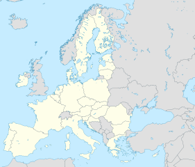
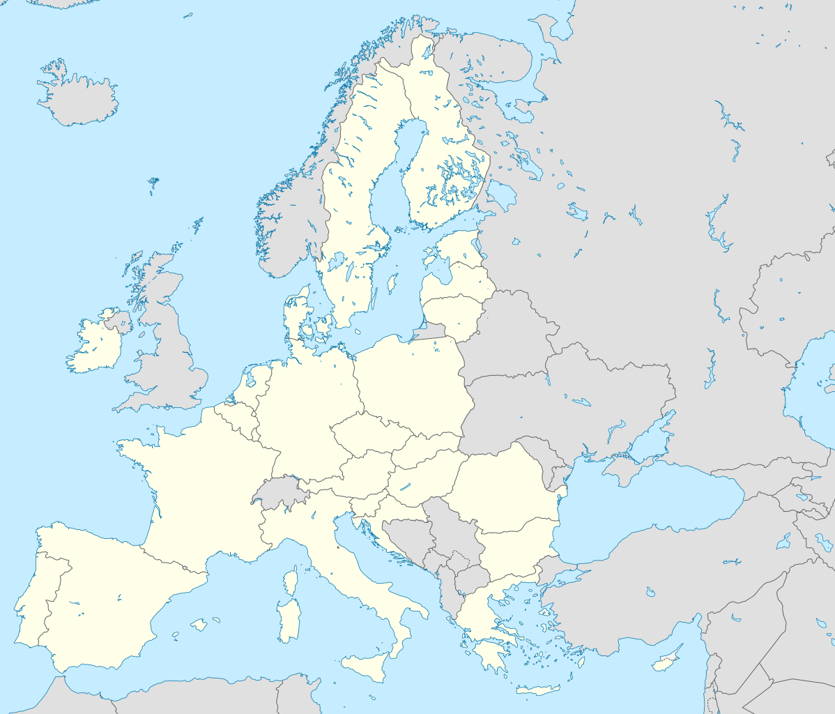
Deutsch: Positionskarte Europa, Europäische Union; Politisch mit Staatsgrenzen; Flächentreue Azimutalprojektion
English: Location map Europe, European Union; Political with state boundaries; Lambert azimuthal equal-area projection
Français : Carte de localisationEurope, Union européenne; Politique avec frontières d'Etats; Projection azimuthale de Lambert
|
| ದಿನಾಂಕ | |
| ಆಕರ |
ಸ್ವಂತ ಕೆಲಸ
|
| ಕರ್ತೃ | Alexrk2 |
| ಇತರೆ ಆವೃತ್ತಿಗಳು |
[]
|


.svg)


|
This map has been made or improved in the German Kartenwerkstatt (Map Lab). You can propose maps to improve as well.
|
ಪರವಾನಗಿ
I, the copyright holder of this work, hereby publish it under the following license:
ಈ ಕಡತ ಕ್ರಿಯೇಟಿವ್ ಕಾಮನ್ಸ್ Attribution
-Share Alike 3.0 Unported ಪರವಾನಗಿ ಹೊಂದಿದೆ.
- ನೀವು ಮುಕ್ತ:
- ಹಂಚಿಕೆಗೆ – ಕೆಲಸವನ್ನು ನಕಲು ಮಾಡಲು, ವಿತರಣೆ ಮತ್ತು ಸಾಗಿಸಲು
- ರೀಮಿಕ್ಸ್ ಮಾಡಲು – ಕೆಲಸವನ್ನು ಬಳಸಿಕೊಳ್ಳಲು
- ಈ ಕೆಳಗಿನ ಷರತ್ತುಗಳಲ್ಲಿ:
- ವೈಶಿಷ್ಟ್ಯ – ನೀವು ಸೂಕ್ತವಾದ ಕ್ರೆಡಿಟ್ ನೀಡಬೇಕು, ಪರವಾನಗಿಗೆ ಲಿಂಕ್ ಅನ್ನು ಒದಗಿಸಬೇಕು ಮತ್ತು ಯಾವುದೇ ಬದಲಾವಣೆಗಳನ್ನು ಮಾಡಿದ್ದರೆ ಸೂಚಿಸಬೇಕು. ನೀವು ಯಾವುದೇ ಸಮಂಜಸವಾದ ರೀತಿಯಲ್ಲಿ ಮಾಡಬಹುದು, ಆದರೆ ಪರವಾನಗಿದಾರರು ನಿಮ್ಮನ್ನು ಅಥವಾ ನಿಮ್ಮ ಯಾವುದೇ ಬಳಕೆಯನ್ನು ಅನುಮೋದಿಸಿದಂತೆ ರೀತಿಯಲ್ಲಿ ಉಪಯೋಗಿಸಬಾರದು.
- ಇರುವುದರಂತೆಯೇ ಹಂಚು – ನೀವು ರೀಮಿಕ್ಸ್ ಮಾಡಿದರೆ, ರೂಪಾಂತರಗೊಳಿಸಿದರೆ ಅಥವಾ ವಸ್ತುವಿನ ಮೇಲೆ ನಿರ್ಮಿಸಿದರೆ, ನಿಮ್ಮ ಕೊಡುಗೆಗಳನ್ನು ನೀವು ಮೂಲದಂತೆ ಅದೇ ಅಥವಾ ಹೊಂದಾಣಿಕೆಯ ಪರವಾನಗಿ ಅಡಿಯಲ್ಲಿ ವಿತರಿಸಬೇಕು.
ಕಡತದ ಇತಿಹಾಸ
ದಿನ/ಕಾಲ ಒತ್ತಿದರೆ ಆ ಸಮಯದಲ್ಲಿ ಈ ಕಡತದ ವಸ್ತುಸ್ಥಿತಿ ತೋರುತ್ತದೆ.
| ದಿನ/ಕಾಲ | ಕಿರುನೋಟ | ಆಯಾಮಗಳು | ಬಳಕೆದಾರ | ಟಿಪ್ಪಣಿ | |
|---|---|---|---|---|---|
| ಪ್ರಸಕ್ತ | ೧೦:೩೧, ೧೧ ಮಾರ್ಚ್ ೨೦೨೦ | | ೧,೪೦೧ × ೧,೧೯೮ (೧.೪೩ MB) | Ratherous | Fix inland water |
| ೧೫:೫೧, ೧ ಫೆಬ್ರವರಿ ೨೦೨೦ |  | ೧,೪೦೧ × ೧,೧೯೮ (೧.೮೪ MB) | Thayts | fixing inland water | |
| ೧೫:೩೬, ೧ ಫೆಬ್ರವರಿ ೨೦೨೦ |  | ೧,೪೦೧ × ೧,೧೯೮ (೧.೪೮ MB) | Mibblepedia | Reverted to version as of 09:30, 1 February 2020 (UTC) - Browser refresh issue, sorry for the spam | |
| ೧೫:೨೩, ೧ ಫೆಬ್ರವರಿ ೨೦೨೦ |  | ೧,೪೦೧ × ೧,೧೯೮ (೧.೪೮ MB) | Mibblepedia | Meaningful change to try to fix upload | |
| ೧೫:೧೮, ೧ ಫೆಬ್ರವರಿ ೨೦೨೦ |  | ೧,೪೦೧ × ೧,೧೯೮ (೧.೪೮ MB) | Mibblepedia | Meaningless file change to try to fix upload | |
| ೧೫:೧೧, ೧ ಫೆಬ್ರವರಿ ೨೦೨೦ |  | ೧,೪೦೧ × ೧,೧೯೮ (೧.೪೮ MB) | Mibblepedia | Removed United Kingdom (again) | |
| ೧೫:೧೦, ೧ ಫೆಬ್ರವರಿ ೨೦೨೦ |  | ೧,೪೦೧ × ೧,೧೯೮ (೧.೪೮ MB) | Mibblepedia | Reverted to version as of 17:57, 8 September 2014 (UTC) - Reverting to older version to try to fix weirdness | |
| ೧೫:೦೨, ೧ ಫೆಬ್ರವರಿ ೨೦೨೦ |  | ೧,೪೦೧ × ೧,೧೯೮ (೧.೪೮ MB) | Mibblepedia | Reverted to version as of 09:30, 1 February 2020 (UTC) - Something weird happened | |
| ೧೫:೦೦, ೧ ಫೆಬ್ರವರಿ ೨೦೨೦ |  | ೧,೪೦೧ × ೧,೧೯೮ (೧.೪೮ MB) | Mibblepedia | Removed United Kingdom | |
| ೧೫:೦೦, ೧ ಫೆಬ್ರವರಿ ೨೦೨೦ |  | ೧,೪೦೧ × ೧,೧೯೮ (೧.೪೮ MB) | Thayts | UK is out |
ಕಡತ ಬಳಕೆ
ಈ ಕೆಳಗಿನ ಪುಟವು ಈ ಚಿತ್ರಕ್ಕೆ ಸಂಪರ್ಕ ಹೊಂದಿದೆ:
ಜಾಗತಿಕ ಕಡತ ಉಪಯೋಗ
ಈ ಕಡತವನ್ನು ಕೆಳಗಿನ ಬೇರೆ ವಿಕಿಗಳೂ ಉಪಯೋಗಿಸುತ್ತಿವೆ:
- als.wikipedia.org ಮೇಲೆ ಬಳಕೆ
- ar.wikipedia.org ಮೇಲೆ ಬಳಕೆ
- azb.wikipedia.org ಮೇಲೆ ಬಳಕೆ
- az.wikipedia.org ಮೇಲೆ ಬಳಕೆ
- ba.wikipedia.org ಮೇಲೆ ಬಳಕೆ
- bn.wikipedia.org ಮೇಲೆ ಬಳಕೆ
- ceb.wikipedia.org ಮೇಲೆ ಬಳಕೆ
- da.wikipedia.org ಮೇಲೆ ಬಳಕೆ
- de.wikipedia.org ಮೇಲೆ ಬಳಕೆ
- en.wikipedia.org ಮೇಲೆ ಬಳಕೆ
- European Environment Agency
- Stockholm
- Nicosia
- Valletta
- Drottningholm
- Kiruna
- Nykøbing Falster
- European Capital of Culture
- Europol
- European Agency for Safety and Health at Work
- European Union Aviation Safety Agency
- List of urban areas in the European Union
- Broby, Sweden
- Tumba, Sweden
- Märsta
- Kungsängen
- Gustavsberg, Värmdö Municipality
- Åkersberga
- Örbyhus
- Torsås
- Kristianstad
- Osby
- Åstorp
- Ystad
- Lund
ಈ ಫೈಲ್ನ ಹೆಚ್ಚು ಜಾಗತಿಕ ಬಳಕೆಯನ್ನು ವೀಕ್ಷಿಸಿ.