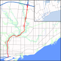
ಚಿತ್ರ:DVP map.svg

Size of this PNG preview of this SVG file: ೬೦೦ × ೬೦೦ ಪಿಕ್ಸೆಲ್ಗಳು. ಇತರ ರೆಸಲ್ಯೂಶನ್ಗಳು: ೨೪೦ × ೨೪೦ ಪಿಕ್ಸೆಲ್ಗಳು | ೪೮೦ × ೪೮೦ ಪಿಕ್ಸೆಲ್ಗಳು | ೭೬೮ × ೭೬೮ ಪಿಕ್ಸೆಲ್ಗಳು | ೧,೦೨೪ × ೧,೦೨೪ ಪಿಕ್ಸೆಲ್ಗಳು | ೨,೦೪೮ × ೨,೦೪೮ ಪಿಕ್ಸೆಲ್ಗಳು | ೧,೪೨೦ × ೧,೪೨೦ ಪಿಕ್ಸೆಲ್ಗಳು.
ಮೂಲ ಕಡತ (SVG ಫೈಲು, ಸುಮಾರಾಗಿ ೧,೪೨೦ × ೧,೪೨೦ ಚಿತ್ರಬಿಂದುಗಳು, ಫೈಲಿನ ಗಾತ್ರ: ೫೪೫ KB)
ಕಡತದ ಇತಿಹಾಸ
ದಿನ/ಕಾಲ ಒತ್ತಿದರೆ ಆ ಸಮಯದಲ್ಲಿ ಈ ಕಡತದ ವಸ್ತುಸ್ಥಿತಿ ತೋರುತ್ತದೆ.
| ದಿನ/ಕಾಲ | ಕಿರುನೋಟ | ಆಯಾಮಗಳು | ಬಳಕೆದಾರ | ಟಿಪ್ಪಣಿ | |
|---|---|---|---|---|---|
| ಪ್ರಸಕ್ತ | ೦೭:೪೩, ೨೩ ಆಗಸ್ಟ್ ೨೦೧೦ |  | ೧,೪೨೦ × ೧,೪೨೦ (೫೪೫ KB) | Floydian | Complete rest of route, expand scope to the east to add a context map of GTA. Add rivers and parkland. |
| ೧೧:೧೪, ೨೪ ಜುಲೈ ೨೦೧೦ |  | ೮೪೦ × ೧,೪೨೦ (೩೦೫ KB) | Floydian | Adjust colours, add rails, some interchanges | |
| ೦೦:೨೧, ೨೧ ಜುಲೈ ೨೦೧೦ |  | ೮೪೦ × ೧,೪೨೦ (೨೯ KB) | Floydian | Fix issues | |
| ೦೦:೦೪, ೨೧ ಜುಲೈ ೨೦೧೦ |  | ೧,೭೦೦ × ೨,೮೦೦ (೩೧ KB) | Floydian | {{Information |Description=A map of the Don Valley Parkway in Toronto, Canada, showing the freeways and arterial roads in the vicinity of it and Lake Ontario. First draft (no interchanges or urban/green landuse) |Source={{own}} based on the map on page 3 |
ಕಡತ ಬಳಕೆ
ಈ ಕೆಳಗಿನ ಪುಟವು ಈ ಚಿತ್ರಕ್ಕೆ ಸಂಪರ್ಕ ಹೊಂದಿದೆ:
ಜಾಗತಿಕ ಕಡತ ಉಪಯೋಗ
ಈ ಕಡತವನ್ನು ಕೆಳಗಿನ ಬೇರೆ ವಿಕಿಗಳೂ ಉಪಯೋಗಿಸುತ್ತಿವೆ:
- en.wikipedia.org ಮೇಲೆ ಬಳಕೆ
- fa.wikipedia.org ಮೇಲೆ ಬಳಕೆ
- fr.wikipedia.org ಮೇಲೆ ಬಳಕೆ
- www.wikidata.org ಮೇಲೆ ಬಳಕೆ
- zh.wikipedia.org ಮೇಲೆ ಬಳಕೆ