ಚಿತ್ರ:Chandigarh Tricity.svg

Size of this PNG preview of this SVG file: ೮೦೦ × ೫೯೧ ಪಿಕ್ಸೆಲ್ಗಳು. ಇತರ ರೆಸಲ್ಯೂಶನ್ಗಳು: ೩೨೦ × ೨೩೬ ಪಿಕ್ಸೆಲ್ಗಳು | ೬೪೦ × ೪೭೩ ಪಿಕ್ಸೆಲ್ಗಳು | ೧,೦೨೪ × ೭೫೭ ಪಿಕ್ಸೆಲ್ಗಳು | ೧,೨೮೦ × ೯೪೬ ಪಿಕ್ಸೆಲ್ಗಳು | ೨,೫೬೦ × ೧,೮೯೨ ಪಿಕ್ಸೆಲ್ಗಳು | ೧,೪೪೪ × ೧,೦೬೭ ಪಿಕ್ಸೆಲ್ಗಳು.
ಮೂಲ ಕಡತ (SVG ಫೈಲು, ಸುಮಾರಾಗಿ ೧,೪೪೪ × ೧,೦೬೭ ಚಿತ್ರಬಿಂದುಗಳು, ಫೈಲಿನ ಗಾತ್ರ: ೧.೨೭ MB)
ಈ ಫೈಲು ವಿಕಿಮೀಡಿಯ ಕಾಮನ್ಸ್ನಲ್ಲಿ ಇರುವುದು. ಅಲ್ಲಿನ ವಿವರಣೆ ಪುಟವನ್ನೇ ಕೆಳಗೆ ತೋರಿಸಲಾಗಿದೆ. ಕಾಮನ್ಸ್ ಕೃತಿಸ್ವಾಮ್ಯತೆಯಿಂದ ಮುಕ್ತ ಫೈಲುಗಳ ಒಂದು ಆಗರ. ಅಲ್ಲಿ ನೀವೂ ಸಹಕರಿಸಬಹುದು. |
ಸಾರಾಂಶ
| ವಿವರ |
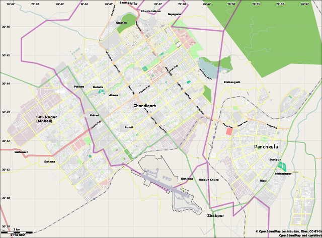
English: Location map for the Chandigarh Tricity, including Chandigarh UT, SAS Nagar, Panchkula and Zirakpur. |
| ದಿನಾಂಕ | |
| ಆಕರ | OpenStreetMap.org (using Maperitive to create SVG file) |
| ಕರ್ತೃ | Cropping by RaviC, OSM authors for map data |
| Camera location | | View this and other nearby images on: OpenStreetMap |
|---|
ಪರವಾನಗಿ
| This work contains information from OpenStreetMap, which is made available under the Open Database License (ODbL).
The ODbL does not require any particular license for maps produced from ODbL data. Prior to 1 August 2020, map tiles produced by the OpenStreetMap Foundation were licensed under the CC-BY-SA-2.0 license. Maps produced by other people may be subject to other licences. |
ಕಡತದ ಇತಿಹಾಸ
ದಿನ/ಕಾಲ ಒತ್ತಿದರೆ ಆ ಸಮಯದಲ್ಲಿ ಈ ಕಡತದ ವಸ್ತುಸ್ಥಿತಿ ತೋರುತ್ತದೆ.
| ದಿನ/ಕಾಲ | ಕಿರುನೋಟ | ಆಯಾಮಗಳು | ಬಳಕೆದಾರ | ಟಿಪ್ಪಣಿ | |
|---|---|---|---|---|---|
| ಪ್ರಸಕ್ತ | ೨೨:೩೧, ೨೦ ಮಾರ್ಚ್ ೨೦೨೧ | | ೧,೪೪೪ × ೧,೦೬೭ (೧.೨೭ MB) | RaviC | fixed Zirakpur |
| ೧೯:೫೩, ೧೧ ಜೂನ್ ೨೦೧೪ |  | ೧,೪೪೪ × ೧,೦೬೭ (೧.೧೬ MB) | RaviC | User created page with UploadWizard |
ಕಡತ ಬಳಕೆ
ಈ ಕೆಳಗಿನ ಪುಟವು ಈ ಚಿತ್ರಕ್ಕೆ ಸಂಪರ್ಕ ಹೊಂದಿದೆ:
ಜಾಗತಿಕ ಕಡತ ಉಪಯೋಗ
ಈ ಕಡತವನ್ನು ಕೆಳಗಿನ ಬೇರೆ ವಿಕಿಗಳೂ ಉಪಯೋಗಿಸುತ್ತಿವೆ:
- bn.wikipedia.org ಮೇಲೆ ಬಳಕೆ
- bs.wikipedia.org ಮೇಲೆ ಬಳಕೆ
- ceb.wikipedia.org ಮೇಲೆ ಬಳಕೆ
- en.wikipedia.org ಮೇಲೆ ಬಳಕೆ
- Chandigarh
- Sukhna Lake
- Mani Majra
- Chandigarh Capital Region
- Chandigarh Airport
- Goswami Ganesh Dutta Sanatan Dharma College
- DAV College, Chandigarh
- Module:Location map/data/India Chandigarh/doc
- Open Hand Monument
- Secretariat Building, Chandigarh
- Palace of Assembly
- Chandigarh Junction railway station
- Sector 56, Mohali
- Parrot Bird Sanctuary, Chandigarh
- User:Xkd2626/sandbox
- Module:Location map/data/India Chandigarh
- January 1970
- User:Hstar24/sandbox
- Sector-17, Chandigarh
- Kaimbwala
- es.wikipedia.org ಮೇಲೆ ಬಳಕೆ
- fa.wikipedia.org ಮೇಲೆ ಬಳಕೆ
- fr.wikipedia.org ಮೇಲೆ ಬಳಕೆ
- gu.wikipedia.org ಮೇಲೆ ಬಳಕೆ
- id.wikipedia.org ಮೇಲೆ ಬಳಕೆ
- ml.wikipedia.org ಮೇಲೆ ಬಳಕೆ
- or.wikipedia.org ಮೇಲೆ ಬಳಕೆ
- pa.wikipedia.org ಮೇಲೆ ಬಳಕೆ
- pl.wikipedia.org ಮೇಲೆ ಬಳಕೆ
- pl.wikibooks.org ಮೇಲೆ ಬಳಕೆ
- si.wikipedia.org ಮೇಲೆ ಬಳಕೆ
- ta.wikipedia.org ಮೇಲೆ ಬಳಕೆ
ಈ ಫೈಲ್ನ ಹೆಚ್ಚು ಜಾಗತಿಕ ಬಳಕೆಯನ್ನು ವೀಕ್ಷಿಸಿ.