ಚಿತ್ರ:Cg-map.png
ಇದಕ್ಕಿಂತ ಹೆಚ್ಚಿನ ವಿವರವಾದ ನೋಟ ಇಲ್ಲ.
Cg-map.png (೩೨೬ × ೩೫೦ ಚಿತ್ರಬಿಂದು, ಫೈಲಿನ ಗಾತ್ರ: ೧೯ KB, MIME ಪ್ರಕಾರ: image/png)
ಈ ಫೈಲು ವಿಕಿಮೀಡಿಯ ಕಾಮನ್ಸ್ನಲ್ಲಿ ಇರುವುದು. ಅಲ್ಲಿನ ವಿವರಣೆ ಪುಟವನ್ನೇ ಕೆಳಗೆ ತೋರಿಸಲಾಗಿದೆ. ಕಾಮನ್ಸ್ ಕೃತಿಸ್ವಾಮ್ಯತೆಯಿಂದ ಮುಕ್ತ ಫೈಲುಗಳ ಒಂದು ಆಗರ. ಅಲ್ಲಿ ನೀವೂ ಸಹಕರಿಸಬಹುದು. |
ಸಾರಾಂಶ
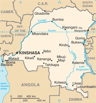
| ವಿವರ | Democratic Republic of the Congo map from CIA World Factbook, converted from original GIF format (July 2011 version showing South Sudan) |
| ದಿನಾಂಕ | |
| ಆಕರ |
CIA World Factbook |
| ಕರ್ತೃ | United States Central Intelligence Agency |
| ಇತರೆ ಆವೃತ್ತಿಗಳು |
|
ಪರವಾನಗಿ
This image is in the public domain because it contains materials that originally came from the United States Central Intelligence Agency's World Factbook.
|
 |
Derivative works
Derivatives of 2011 map (showing South Sudan):
-
 Congo CIA map PL.png
polski

Derivatives of 2002 map:
-
 Congo Rep Dem carte.gif
français -
 DRK kaart.png
Afrikaans -
 Karte der Demokratischen Republik Kongo.png
Deutsch -
 Mapa dem rep Kongo.png
čeština


ಕಡತದ ಇತಿಹಾಸ
ದಿನ/ಕಾಲ ಒತ್ತಿದರೆ ಆ ಸಮಯದಲ್ಲಿ ಈ ಕಡತದ ವಸ್ತುಸ್ಥಿತಿ ತೋರುತ್ತದೆ.
| ದಿನ/ಕಾಲ | ಕಿರುನೋಟ | ಆಯಾಮಗಳು | ಬಳಕೆದಾರ | ಟಿಪ್ಪಣಿ | |
|---|---|---|---|---|---|
| ಪ್ರಸಕ್ತ | ೧೫:೫೨, ೧೭ ಜನವರಿ ೨೦೨೨ | | ೩೨೬ × ೩೫೦ (೧೯ KB) | Lojwe | Cropped 1 % horizontally, 1 % vertically using CropTool with precise mode. |
| ೧೩:೫೮, ೧೪ ಸೆಪ್ಟೆಂಬರ್ ೨೦೧೬ |  | ೩೩೦ × ೩೫೪ (೫೫ KB) | Yerpo | Reverted to version as of 00:12, 13 July 2011 (UTC) | |
| ೦೫:೩೦, ೧೪ ಸೆಪ್ಟೆಂಬರ್ ೨೦೧೬ |  | ೩೫೪ × ೩೩೦ (೨೦ KB) | SteinsplitterBot | Bot: Image rotated by 90° | |
| ೦೫:೪೨, ೧೩ ಜುಲೈ ೨೦೧೧ |  | ೩೩೦ × ೩೫೪ (೫೫ KB) | Béka~commonswiki | new version with South Sudan, from CIA | |
| ೦೪:೨೩, ೫ ಮಾರ್ಚ್ ೨೦೦೫ |  | ೩೩೦ × ೩೫೫ (೧೪ KB) | Alfio | CIA map of Congo Democratic Republic |
ಕಡತ ಬಳಕೆ
ಈ ಕೆಳಗಿನ 2 ಪುಟಗಳು ಈ ಚಿತ್ರಕ್ಕೆ ಸಂಪರ್ಕ ಹೊಂದಿವೆ:
ಜಾಗತಿಕ ಕಡತ ಉಪಯೋಗ
ಈ ಕಡತವನ್ನು ಕೆಳಗಿನ ಬೇರೆ ವಿಕಿಗಳೂ ಉಪಯೋಗಿಸುತ್ತಿವೆ:
- ab.wikipedia.org ಮೇಲೆ ಬಳಕೆ
- ar.wikipedia.org ಮೇಲೆ ಬಳಕೆ
- azb.wikipedia.org ಮೇಲೆ ಬಳಕೆ
- be-tarask.wikipedia.org ಮೇಲೆ ಬಳಕೆ
- be.wikipedia.org ಮೇಲೆ ಬಳಕೆ
- bn.wikipedia.org ಮೇಲೆ ಬಳಕೆ
- ca.wikipedia.org ಮೇಲೆ ಬಳಕೆ
- cy.wikipedia.org ಮೇಲೆ ಬಳಕೆ
- da.wikipedia.org ಮೇಲೆ ಬಳಕೆ
- de.wiktionary.org ಮೇಲೆ ಬಳಕೆ
- en.wikipedia.org ಮೇಲೆ ಬಳಕೆ
- Democratic Republic of the Congo
- Oral polio vaccine AIDS hypothesis
- Portal:Democratic Republic of the Congo
- Index of Democratic Republic of the Congo–related articles
- Wikipedia:WikiProject Democratic Republic of the Congo
- User:SmithBlue/AIDSOPVuniverse
- 2008 Congo football riots
- Sexual violence in the Democratic Republic of the Congo
- User:Francish7
- Template:User WikiProject Democratic Republic of the Congo
- Category:WikiProject Democratic Republic of the Congo participants
- User:NhInsideWriter
- Module:Location map/data/Democratic Republic of the Congo/doc
- Wikipedia:Userboxes/WikiProjects/Regional/03
- User:Crtew/Serge Maheshe
- Wikipedia:Userboxes/WikiProjects/alphabetical/08
- Wikipedia:Userboxes/WikiProjects/alphabetical/09
- Module:Location map/data/Democratic Republic of the Congo
- Wikipedia:Userboxes/Location/Democratic Republic of the Congo
- The Democratic Republic of the Congo and the World Bank
- User:Unbeatable101/sandbox/DRoC
- User:Northamerica1000/Portals of the world
- en.wikinews.org ಮೇಲೆ ಬಳಕೆ
- en.wikiversity.org ಮೇಲೆ ಬಳಕೆ
ಈ ಫೈಲ್ನ ಹೆಚ್ಚು ಜಾಗತಿಕ ಬಳಕೆಯನ್ನು ವೀಕ್ಷಿಸಿ.