ಚಿತ್ರ:Australia Victoria Glenelg Shire location map.svg

Size of this PNG preview of this SVG file: ೪೨೧ × ೬೦೦ ಪಿಕ್ಸೆಲ್ಗಳು. ಇತರ ರೆಸಲ್ಯೂಶನ್ಗಳು: ೧೬೮ × ೨೪೦ ಪಿಕ್ಸೆಲ್ಗಳು | ೩೩೭ × ೪೮೦ ಪಿಕ್ಸೆಲ್ಗಳು | ೫೩೯ × ೭೬೮ ಪಿಕ್ಸೆಲ್ಗಳು | ೭೧೯ × ೧,೦೨೪ ಪಿಕ್ಸೆಲ್ಗಳು | ೧,೪೩೮ × ೨,೦೪೮ ಪಿಕ್ಸೆಲ್ಗಳು | ೫೩೩ × ೭೫೯ ಪಿಕ್ಸೆಲ್ಗಳು.
ಮೂಲ ಕಡತ (SVG ಫೈಲು, ಸುಮಾರಾಗಿ ೫೩೩ × ೭೫೯ ಚಿತ್ರಬಿಂದುಗಳು, ಫೈಲಿನ ಗಾತ್ರ: ೫೦೬ KB)
ಈ ಫೈಲು ವಿಕಿಮೀಡಿಯ ಕಾಮನ್ಸ್ನಲ್ಲಿ ಇರುವುದು. ಅಲ್ಲಿನ ವಿವರಣೆ ಪುಟವನ್ನೇ ಕೆಳಗೆ ತೋರಿಸಲಾಗಿದೆ. ಕಾಮನ್ಸ್ ಕೃತಿಸ್ವಾಮ್ಯತೆಯಿಂದ ಮುಕ್ತ ಫೈಲುಗಳ ಒಂದು ಆಗರ. ಅಲ್ಲಿ ನೀವೂ ಸಹಕರಿಸಬಹುದು. |
| ವಿವರ |
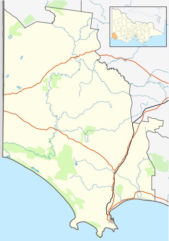
English: Blank map of w:Glenelg Shire, Victoria, Australia, with the following information shown:
Geographic limits:
|
||
| ಆಕರ | ಸ್ವಂತ ಕೆಲಸ + VicMap Lite | ||
| ಕರ್ತೃ | Cassowary |

| Annotations | This image is annotated: View the annotations at Commons |
ಕಡತದ ಇತಿಹಾಸ
ದಿನ/ಕಾಲ ಒತ್ತಿದರೆ ಆ ಸಮಯದಲ್ಲಿ ಈ ಕಡತದ ವಸ್ತುಸ್ಥಿತಿ ತೋರುತ್ತದೆ.
| ದಿನ/ಕಾಲ | ಕಿರುನೋಟ | ಆಯಾಮಗಳು | ಬಳಕೆದಾರ | ಟಿಪ್ಪಣಿ | |
|---|---|---|---|---|---|
| ಪ್ರಸಕ್ತ | ೨೦:೧೨, ೧೭ ಫೆಬ್ರವರಿ ೨೦೧೧ | | ೫೩೩ × ೭೫೯ (೫೦೬ KB) | Cassowary | {{Information |Description ={{en|1= Blank map of w:Glenelg Shire, Victoria, Australia, with the following information shown: * LGA boundaries * Coastline, lakes and rivers * Roads and railways * Urban areas * Parks Geographic limits: * North: 37.3 |
ಕಡತ ಬಳಕೆ
ಈ ಕೆಳಗಿನ ಪುಟವು ಈ ಚಿತ್ರಕ್ಕೆ ಸಂಪರ್ಕ ಹೊಂದಿದೆ:
ಜಾಗತಿಕ ಕಡತ ಉಪಯೋಗ
ಈ ಕಡತವನ್ನು ಕೆಳಗಿನ ಬೇರೆ ವಿಕಿಗಳೂ ಉಪಯೋಗಿಸುತ್ತಿವೆ:
- ar.wikipedia.org ಮೇಲೆ ಬಳಕೆ
- ceb.wikipedia.org ಮೇಲೆ ಬಳಕೆ
- en.wikipedia.org ಮೇಲೆ ಬಳಕೆ
- Portland, Victoria
- Shire of Glenelg
- Heywood, Victoria
- Allestree, Victoria
- Nelson, Victoria
- Cape Bridgewater
- Casterton, Victoria
- Dartmoor, Victoria
- Merino, Victoria
- Template:Towns in Glenelg Shire
- Tyrendarra
- Henty, Victoria
- Narrawong
- Condah
- Digby, Victoria
- Sandford, Victoria
- Module:Location map/data/Australia Victoria Shire of Glenelg/doc
- Lawrence Rocks
- Tahara, Victoria
- Paschendale, Victoria
- Gorae West
- Heathmere
- Hotspur, Victoria
- Drumborg
- Module:Location map/data/Australia Victoria Shire of Glenelg
- Bahgallah
- Bolwarra, Victoria
- Breakaway Creek, Victoria
- Brimboal
- Carapook
- Cashmore, Victoria
- Chetwynd, Victoria
- User:Viatori/sandbox
- User:ThylacineHunter/LGA
- fa.wikipedia.org ಮೇಲೆ ಬಳಕೆ
- incubator.wikimedia.org ಮೇಲೆ ಬಳಕೆ
- pnb.wikipedia.org ಮೇಲೆ ಬಳಕೆ
- si.wikipedia.org ಮೇಲೆ ಬಳಕೆ
- tr.wikipedia.org ಮೇಲೆ ಬಳಕೆ
- ur.wikipedia.org ಮೇಲೆ ಬಳಕೆ
- uz.wikipedia.org ಮೇಲೆ ಬಳಕೆ
- vi.wikipedia.org ಮೇಲೆ ಬಳಕೆ
- war.wikipedia.org ಮೇಲೆ ಬಳಕೆ