ಚಿತ್ರ:Australia Victoria East Gippsland Shire location map.svg

Size of this PNG preview of this SVG file: ೫೩೩ × ೩೫೩ ಪಿಕ್ಸೆಲ್ಗಳು. ಇತರ ರೆಸಲ್ಯೂಶನ್ಗಳು: ೩೨೦ × ೨೧೨ ಪಿಕ್ಸೆಲ್ಗಳು | ೬೪೦ × ೪೨೪ ಪಿಕ್ಸೆಲ್ಗಳು | ೧,೦೨೪ × ೬೭೮ ಪಿಕ್ಸೆಲ್ಗಳು | ೧,೨೮೦ × ೮೪೮ ಪಿಕ್ಸೆಲ್ಗಳು | ೨,೫೬೦ × ೧,೬೯೫ ಪಿಕ್ಸೆಲ್ಗಳು.
ಮೂಲ ಕಡತ (SVG ಫೈಲು, ಸುಮಾರಾಗಿ ೫೩೩ × ೩೫೩ ಚಿತ್ರಬಿಂದುಗಳು, ಫೈಲಿನ ಗಾತ್ರ: ೮೯೩ KB)
ಈ ಫೈಲು ವಿಕಿಮೀಡಿಯ ಕಾಮನ್ಸ್ನಲ್ಲಿ ಇರುವುದು. ಅಲ್ಲಿನ ವಿವರಣೆ ಪುಟವನ್ನೇ ಕೆಳಗೆ ತೋರಿಸಲಾಗಿದೆ. ಕಾಮನ್ಸ್ ಕೃತಿಸ್ವಾಮ್ಯತೆಯಿಂದ ಮುಕ್ತ ಫೈಲುಗಳ ಒಂದು ಆಗರ. ಅಲ್ಲಿ ನೀವೂ ಸಹಕರಿಸಬಹುದು. |
| ವಿವರ |
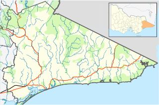
English: Blank map of w:East Gippsland Shire, Victoria, Australia, with the following information shown:
Geographic limits:
|
||
| ಆಕರ | ಸ್ವಂತ ಕೆಲಸ + VicMap Lite | ||
| ಕರ್ತೃ | Cassowary |

ಕಡತದ ಇತಿಹಾಸ
ದಿನ/ಕಾಲ ಒತ್ತಿದರೆ ಆ ಸಮಯದಲ್ಲಿ ಈ ಕಡತದ ವಸ್ತುಸ್ಥಿತಿ ತೋರುತ್ತದೆ.
| ದಿನ/ಕಾಲ | ಕಿರುನೋಟ | ಆಯಾಮಗಳು | ಬಳಕೆದಾರ | ಟಿಪ್ಪಣಿ | |
|---|---|---|---|---|---|
| ಪ್ರಸಕ್ತ | ೧೮:೨೬, ೧೭ ಫೆಬ್ರವರಿ ೨೦೧೧ | | ೫೩೩ × ೩೫೩ (೮೯೩ KB) | Cassowary | {{Information |Description ={{en|1=Blank map of w:East Gippsland Shire, Victoria, Australia, with the following information shown: * LGA boundaries * Coastline, lakes and rivers * Roads and railways * Urban areas * Parks Geographic limits: * North |
ಕಡತ ಬಳಕೆ
ಈ ಕೆಳಗಿನ ಪುಟವು ಈ ಚಿತ್ರಕ್ಕೆ ಸಂಪರ್ಕ ಹೊಂದಿದೆ:
ಜಾಗತಿಕ ಕಡತ ಉಪಯೋಗ
ಈ ಕಡತವನ್ನು ಕೆಳಗಿನ ಬೇರೆ ವಿಕಿಗಳೂ ಉಪಯೋಗಿಸುತ್ತಿವೆ:
- ar.wikipedia.org ಮೇಲೆ ಬಳಕೆ
- ceb.wikipedia.org ಮೇಲೆ ಬಳಕೆ
- en.wikipedia.org ಮೇಲೆ ಬಳಕೆ
- Shire of East Gippsland
- Goongerah, Victoria
- Mallacoota, Victoria
- Bairnsdale
- Lakes Entrance, Victoria
- Paynesville, Victoria
- Raymond Island
- Orbost
- Gabo Island
- Swifts Creek
- Buchan, Victoria
- Cann River, Victoria
- Omeo
- Nowa Nowa, Victoria
- Ensay, Victoria
- Benambra, Victoria
- Bruthen, Victoria
- Metung
- Newmerella, Victoria
- Cassilis, Victoria
- Bemm River, Victoria
- Genoa, Victoria
- Rotamah Island
- Tullaberga Island
- Omeo & District Football League
- East Gippsland Football League
- Swan Reach, Victoria
- Marlo, Victoria
- Johnsonville, Victoria
- Nicholson, Victoria
- Fernbank, Victoria
- Template:Towns in East Gippsland Shire
- W Tree, Victoria
- Orbost railway station
- Cape Conran
- Lindenow, Victoria
- Anglers Rest, Victoria
- Module:Location map/data/Australia Victoria Shire of East Gippsland/doc
- Bonang Road
- Tambo Crossing, Victoria
- Eagle Point, Victoria
- Suggan Buggan, Victoria
- Eastwood, Victoria
- Lake Tyers Mission
- Lucknow, Victoria
- The Skerries (Victoria)
- Wy Yung, Victoria
- Module:Location map/data/Australia Victoria Shire of East Gippsland
ಈ ಫೈಲ್ನ ಹೆಚ್ಚು ಜಾಗತಿಕ ಬಳಕೆಯನ್ನು ವೀಕ್ಷಿಸಿ.