ಮೂಲ ಕಡತ(SVG ಫೈಲು, ಸುಮಾರಾಗಿ ೭೬೮ × ೧,೧೫೯ ಚಿತ್ರಬಿಂದುಗಳು, ಫೈಲಿನ ಗಾತ್ರ: ೩೧೧ KB)

ಸಾರಾಂಶ

ವಿವರ
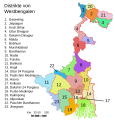
English: Original summary by creator of base svg file deeptrivia. Districts of West Bengal

Based on https://web.archive.org/web/20040606103522/www.censusindia.net/results/2001maps/wbengal01.html

Modifications by Mouryan:

  1. upladed translated version of File:WestBengalDistricts numbered de.svg.
  2. The districts of Dakshin 24 Parganas district and Uttar 24 Parganas were incorrectly numbered in the Map. The errors have been rectified.

Modifications by Furfur:

  1. The 4 (four) new districts of West Bengal namely Paschim Bardhaman district (bifurcated from Bardhaman district), Kalimpong district (bifurcated from Darjeeling district), Alipurduar district (bifurcated from Jalpaiguri district) and Jhargram district (bifurcated from Paschim Medinipur district) has been shown in this new Updated map.

Modifications by Antorjal:

  1. Midnapore District has been bifurcated to show both Paschim Medinipur and Purba Medinipur.
  2. Numbered and listed districts per comments at peer-review.
  3. Font size reduced for clarity, since the districts are now listed.
  4. Many of the spellings did not conform to linked articles in the text. All spellings now match the West Bengal article spellings.
ದಿನಾಂಕ ಅಕ್ಟೋಬರ್ ೮, ೨೦೦೬ (original upload date)
ಆಕರ Transferred from en.wikipedia to Commons by Padawane.
ಕರ್ತೃ The original uploader was Antorjal at ಇಂಗ್ಲಿಷ್ ವಿಕಿಪೀಡಿಯ.
ಇತರೆ ಆವೃತ್ತಿಗಳು

[ಸಂಪಾದಿಸಿ]

SVG genesis
InfoField
 
The source code of this SVG is invalid due to an error.
 
This W3C-invalid map was created with Adobe Illustrator,
 
and with Inkscape.
 
 This map uses embedded text that can be easily translated using a text editor.

ಪರವಾನಗಿ

w:en:Creative Commons
ವೈಶಿಷ್ಟ್ಯ ಇರುವುದರಂತೆಯೇ ಹಂಚು
This file is licensed under the Creative Commons Attribution-Share Alike 2.5 Generic, 2.0 Generic and 1.0 Generic license.
ನೀವು ಮುಕ್ತ:
  • ಹಂಚಿಕೆಗೆ – ಕೆಲಸವನ್ನು ನಕಲು ಮಾಡಲು, ವಿತರಣೆ ಮತ್ತು ಸಾಗಿಸಲು
  • ರೀಮಿಕ್ಸ್ ಮಾಡಲು – ಕೆಲಸವನ್ನು ಬಳಸಿಕೊಳ್ಳಲು
ಈ ಕೆಳಗಿನ ಷರತ್ತುಗಳಲ್ಲಿ:
  • ವೈಶಿಷ್ಟ್ಯ – ನೀವು ಸೂಕ್ತವಾದ ಕ್ರೆಡಿಟ್ ನೀಡಬೇಕು, ಪರವಾನಗಿಗೆ ಲಿಂಕ್ ಅನ್ನು ಒದಗಿಸಬೇಕು ಮತ್ತು ಯಾವುದೇ ಬದಲಾವಣೆಗಳನ್ನು ಮಾಡಿದ್ದರೆ ಸೂಚಿಸಬೇಕು. ನೀವು ಯಾವುದೇ ಸಮಂಜಸವಾದ ರೀತಿಯಲ್ಲಿ ಮಾಡಬಹುದು, ಆದರೆ ಪರವಾನಗಿದಾರರು ನಿಮ್ಮನ್ನು ಅಥವಾ ನಿಮ್ಮ ಯಾವುದೇ ಬಳಕೆಯನ್ನು ಅನುಮೋದಿಸಿದಂತೆ ರೀತಿಯಲ್ಲಿ ಉಪಯೋಗಿಸಬಾರದು.
  • ಇರುವುದರಂತೆಯೇ ಹಂಚು – ನೀವು ರೀಮಿಕ್ಸ್ ಮಾಡಿದರೆ, ರೂಪಾಂತರಗೊಳಿಸಿದರೆ ಅಥವಾ ವಸ್ತುವಿನ ಮೇಲೆ ನಿರ್ಮಿಸಿದರೆ, ನಿಮ್ಮ ಕೊಡುಗೆಗಳನ್ನು ನೀವು ಮೂಲದಂತೆ ಅದೇ ಅಥವಾ ಹೊಂದಾಣಿಕೆಯ ಪರವಾನಗಿ ಅಡಿಯಲ್ಲಿ ವಿತರಿಸಬೇಕು.
w:en:Creative Commons
ವೈಶಿಷ್ಟ್ಯ ಇರುವುದರಂತೆಯೇ ಹಂಚು
ಈ ಕಡತ ಕ್ರಿಯೇಟಿವ್ ಕಾಮನ್ಸ್ Attribution -Share Alike 3.0 Unported ಪರವಾನಗಿ ಹೊಂದಿದೆ. Subject to disclaimers.
ನೀವು ಮುಕ್ತ:
  • ಹಂಚಿಕೆಗೆ – ಕೆಲಸವನ್ನು ನಕಲು ಮಾಡಲು, ವಿತರಣೆ ಮತ್ತು ಸಾಗಿಸಲು
  • ರೀಮಿಕ್ಸ್ ಮಾಡಲು – ಕೆಲಸವನ್ನು ಬಳಸಿಕೊಳ್ಳಲು
ಈ ಕೆಳಗಿನ ಷರತ್ತುಗಳಲ್ಲಿ:
  • ವೈಶಿಷ್ಟ್ಯ – ನೀವು ಸೂಕ್ತವಾದ ಕ್ರೆಡಿಟ್ ನೀಡಬೇಕು, ಪರವಾನಗಿಗೆ ಲಿಂಕ್ ಅನ್ನು ಒದಗಿಸಬೇಕು ಮತ್ತು ಯಾವುದೇ ಬದಲಾವಣೆಗಳನ್ನು ಮಾಡಿದ್ದರೆ ಸೂಚಿಸಬೇಕು. ನೀವು ಯಾವುದೇ ಸಮಂಜಸವಾದ ರೀತಿಯಲ್ಲಿ ಮಾಡಬಹುದು, ಆದರೆ ಪರವಾನಗಿದಾರರು ನಿಮ್ಮನ್ನು ಅಥವಾ ನಿಮ್ಮ ಯಾವುದೇ ಬಳಕೆಯನ್ನು ಅನುಮೋದಿಸಿದಂತೆ ರೀತಿಯಲ್ಲಿ ಉಪಯೋಗಿಸಬಾರದು.
  • ಇರುವುದರಂತೆಯೇ ಹಂಚು – ನೀವು ರೀಮಿಕ್ಸ್ ಮಾಡಿದರೆ, ರೂಪಾಂತರಗೊಳಿಸಿದರೆ ಅಥವಾ ವಸ್ತುವಿನ ಮೇಲೆ ನಿರ್ಮಿಸಿದರೆ, ನಿಮ್ಮ ಕೊಡುಗೆಗಳನ್ನು ನೀವು ಮೂಲದಂತೆ ಅದೇ ಅಥವಾ ಹೊಂದಾಣಿಕೆಯ ಪರವಾನಗಿ ಅಡಿಯಲ್ಲಿ ವಿತರಿಸಬೇಕು.
This licensing tag was added to this file as part of the GFDL licensing update.
GNU head GNU ಉಚಿತ ಡಾಕ್ಯುಮೆಂಟೇಶನ್ ಪರವಾನಗಿ, ಆವೃತ್ತಿಯ ನಿಯಮಗಳ ಅಡಿಯಲ್ಲಿ ಈ ಡಾಕ್ಯುಮೆಂಟ್ ಅನ್ನು ನಕಲಿಸಲು, ವಿತರಿಸಲು ಮತ್ತು/ಅಥವಾ ಮಾರ್ಪಡಿಸಲು ಅನುಮತಿಯನ್ನು ನೀಡಲಾಗಿದೆ. 1.2 ಅಥವಾ ಯಾವುದೇ ನಂತರದ ಆವೃತ್ತಿಯನ್ನು ಉಚಿತ ಸಾಫ್ಟ್‌ವೇರ್ ಫೌಂಡೇಶನ್ ಪ್ರಕಟಿಸಿದೆ; ಯಾವುದೇ ಅಸ್ಥಿರ ವಿಭಾಗಗಳಿಲ್ಲದೆ, ಮುಖ ಪಠ್ಯಗಳಿಲ್ಲ ಮತ್ತು ಹಿಂದಿನ ಕವರ್ ಪಠ್ಯಗಳಿಲ್ಲ. ಪರವಾನಗಿಯ ಪ್ರತಿಯನ್ನು GNU ಉಚಿತ ಡಾಕ್ಯುಮೆಂಟೇಶನ್ ಪರವಾನಗಿ ಎಂಬ ವಿಭಾಗದಲ್ಲಿ ಸೇರಿಸಲಾಗಿದೆ. Subject to disclaimers.

Original upload log

The original description page was here. All following user names refer to en.wikipedia.
  • 2006-12-25 04:28 Deeptrivia 450×500×0 (102714 bytes) Repair attempt
  • 2006-12-25 04:17 Deeptrivia 450×500×0 (101044 bytes) Repair attempt
  • 2006-10-08 14:21 Antorjal 450×500×0 (100501 bytes) Original summary by creator of base svg file [[User:deeptrivia|deeptrivia]]. Districts of West Bengal Based on http://web.archive.org/web/20040606103522/www.censusindia.net/results/2001maps/wbengal01.html Modifications by [[User:Antorjal|An
  • 2006-10-08 14:17 Antorjal 450×500×0 (100294 bytes) Original summary by creator of base svg file [[User:deeptrivia|deeptrivia]]. Districts of West Bengal Based on http://web.archive.org/web/20040606103522/www.censusindia.net/results/2001maps/wbengal01.html Modifications by [[User:Antorjal|An
  • 2006-10-08 14:15 Antorjal 450×500×0 (100501 bytes) Original summary by creator of base svg file [[User:deeptrivia|deeptrivia]]. Districts of West Bengal Based on http://web.archive.org/web/20040606103522/www.censusindia.net/results/2001maps/wbengal01.html Modifications by [[User:Antorjal|An
  • 2006-10-08 14:09 Antorjal 450×500×0 (100484 bytes) Original summary by creator of base svg file [[User:deeptrivia|deeptrivia]]. Districts of West Bengal Based on http://web.archive.org/web/20040606103522/www.censusindia.net/results/2001maps/wbengal01.html Modifications by [[User:Antorjal|An
  • 2006-10-08 14:05 Antorjal 450×500×0 (100501 bytes) Original summary by creator of base svg file [[User:deeptrivia|deeptrivia]]. Districts of West Bengal Based on http://web.archive.org/web/20040606103522/www.censusindia.net/results/2001maps/wbengal01.html Modifications by [[User:Antorjal|An

Captions

Add a one-line explanation of what this file represents
Map of West Bengal

Items portrayed in this file

depicts ಇಂಗ್ಲಿಷ್

copyright status ಇಂಗ್ಲಿಷ್

copyrighted ಇಂಗ್ಲಿಷ್

೮ ಅಕ್ಟೋಬರ್ 2006

MIME type ಇಂಗ್ಲಿಷ್

image/svg+xml

ಕಡತದ ಇತಿಹಾಸ

ದಿನ/ಕಾಲ ಒತ್ತಿದರೆ ಆ ಸಮಯದಲ್ಲಿ ಈ ಕಡತದ ವಸ್ತುಸ್ಥಿತಿ ತೋರುತ್ತದೆ.

ದಿನ/ಕಾಲಕಿರುನೋಟಆಯಾಮಗಳುಬಳಕೆದಾರಟಿಪ್ಪಣಿ
ಪ್ರಸಕ್ತ೦೨:೩೪, ೨೬ ಏಪ್ರಿಲ್ ೨೦೨೦೦೨:೩೪, ೨೬ ಏಪ್ರಿಲ್ ೨೦೨೦ ವರೆಗಿನ ಆವೃತ್ತಿಯ ಕಿರುನೋಟ೭೬೮ × ೧,೧೫೯ (೩೧೧ KB)Debjitpaul10Updated text
೦೨:೧೫, ೨೬ ಏಪ್ರಿಲ್ ೨೦೨೦೦೨:೧೫, ೨೬ ಏಪ್ರಿಲ್ ೨೦೨೦ ವರೆಗಿನ ಆವೃತ್ತಿಯ ಕಿರುನೋಟ೭೬೮ × ೧,೧೫೯ (೧೧೩ KB)Debjitpaul10Uploaded a corrected and transparent version.
೧೧:೪೫, ೫ ನವೆಂಬರ್ ೨೦೧೭೧೧:೪೫, ೫ ನವೆಂಬರ್ ೨೦೧೭ ವರೆಗಿನ ಆವೃತ್ತಿಯ ಕಿರುನೋಟ೫೭೬ × ೬೦೧ (೧೪೪ KB)Mouryan{{Information |Description={{en|Original summary by creator of base svg file deeptrivia. Districts of West Bengal Based on http://web.archive.org/web/20040606103522/www.censusindia.net/results/2001maps/wbengal01.html Modificati...
೦೮:೨೧, ೫ ನವೆಂಬರ್ ೨೦೧೭೦೮:೨೧, ೫ ನವೆಂಬರ್ ೨೦೧೭ ವರೆಗಿನ ಆವೃತ್ತಿಯ ಕಿರುನೋಟ೫೭೬ × ೬೦೧ (೧೪೪ KB)Mouryan{{Information |Description={{en|Original summary by creator of base svg file deeptrivia. Districts of West Bengal Based on http://web.archive.org/web/20040606103522/www.censusindia.net/results/2001maps/wbengal01.html Modificati...
೧೯:೨೯, ೨೫ ನವೆಂಬರ್ ೨೦೦೮೧೯:೨೯, ೨೫ ನವೆಂಬರ್ ೨೦೦೮ ವರೆಗಿನ ಆವೃತ್ತಿಯ ಕಿರುನೋಟ೧,೫೯೫ × ೨,೨೫೬ (೨೧೨ KB)GDibyendu{{Information |Description=fixed map (sunderbans), fixed district names |Source=based on locator map:West_Bengal_locator_map.svg |Date=2008-11-25 |Author=GDibyendu |Permission=All |other_versions= }}
೦೨:೦೦, ೨೫ ನವೆಂಬರ್ ೨೦೦೮೦೨:೦೦, ೨೫ ನವೆಂಬರ್ ೨೦೦೮ ವರೆಗಿನ ಆವೃತ್ತಿಯ ಕಿರುನೋಟ೪೫೦ × ೫೦೦ (೧೦೦ KB)GDibyenduReverted to version as of 14:58, 17 January 2008 as some error crept in today's attempted upload
೦೧:೪೪, ೨೫ ನವೆಂಬರ್ ೨೦೦೮೦೧:೪೪, ೨೫ ನವೆಂಬರ್ ೨೦೦೮ ವರೆಗಿನ ಆವೃತ್ತಿಯ ಕಿರುನೋಟ೧,೫೯೫ × ೨,೨೫೬ (೧೯೧ KB)GDibyendu{{Information |Description=Corrected the map (it was not showing sunderbans are properly) |Source=This map is based on locator map of West Bengal (West_Bengal_locator_map.svg) |Date=2008-11-24 |Author=GDibyendu |Permission=All |other_versions= }}
೨೩:೧೩, ೨೨ ನವೆಂಬರ್ ೨೦೦೮೨೩:೧೩, ೨೨ ನವೆಂಬರ್ ೨೦೦೮ ವರೆಗಿನ ಆವೃತ್ತಿಯ ಕಿರುನೋಟ೪೫೦ × ೫೦೦ (೧೦೦ KB)GDibyenduReverted to version as of 14:58, 17 January 2008
೨೩:೧೧, ೨೨ ನವೆಂಬರ್ ೨೦೦೮೨೩:೧೧, ೨೨ ನವೆಂಬರ್ ೨೦೦೮ ವರೆಗಿನ ಆವೃತ್ತಿಯ ಕಿರುನೋಟ೪೫೦ × ೫೦೦ (೭ KB)GDibyendu{{Information |Description=Rewrote text in image to improve readability |Source=Based on last version |Date=2008-11-22 |Author=GDibyendu |Permission=All |other_versions= }}
೨೦:೨೮, ೧೭ ಜನವರಿ ೨೦೦೮೨೦:೨೮, ೧೭ ಜನವರಿ ೨೦೦೮ ವರೆಗಿನ ಆವೃತ್ತಿಯ ಕಿರುನೋಟ೪೫೦ × ೫೦೦ (೧೦೦ KB)File Upload Bot (Magnus Manske) {{BotMoveToCommons|en.wikipedia}} {{Information |Description={{en|Original summary by creator of base svg file deeptrivia. Districts of West Bengal Based on http://web.archive.org/web/20040606103522/www.censusindia.net/results/200

ಈ ಕೆಳಗಿನ ಪುಟವು ಈ ಚಿತ್ರಕ್ಕೆ ಸಂಪರ್ಕ ಹೊಂದಿದೆ:

ಜಾಗತಿಕ ಕಡತ ಉಪಯೋಗ

ಈ ಕಡತವನ್ನು ಕೆಳಗಿನ ಬೇರೆ ವಿಕಿಗಳೂ ಉಪಯೋಗಿಸುತ್ತಿವೆ:

ಈ ಫೈಲ್‌ನ ಹೆಚ್ಚು ಜಾಗತಿಕ ಬಳಕೆಯನ್ನು ವೀಕ್ಷಿಸಿ.

ಮೇಲ್ದರ್ಜೆ ಮಾಹಿತಿ

"https://kn.wikipedia.org/wiki/ಚಿತ್ರ:WestBengalDistricts_numbered.svg" ಇಂದ ಪಡೆಯಲ್ಪಟ್ಟಿದೆ