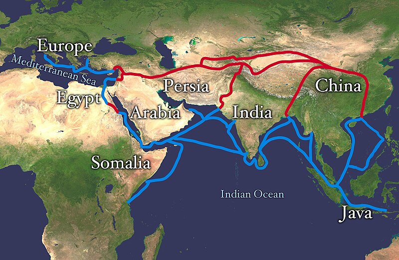
ಚಿತ್ರ:Silk route.jpg

ಈ ಮುನ್ನೋಟ ಗಾತ್ರ:೮೦೦ × ೫೨೧ ಪಿಕ್ಸೆಲ್ಗಳು. ಇತರ ರೆಸಲ್ಯೂಶನ್ಗಳು: ೩೨೦ × ೨೦೮ ಪಿಕ್ಸೆಲ್ಗಳು | ೬೪೦ × ೪೧೬ ಪಿಕ್ಸೆಲ್ಗಳು | ೧,೦೨೪ × ೬೬೬ ಪಿಕ್ಸೆಲ್ಗಳು | ೧,೨೮೦ × ೮೩೩ ಪಿಕ್ಸೆಲ್ಗಳು | ೨,೮೬೮ × ೧,೮೬೬ ಪಿಕ್ಸೆಲ್ಗಳು.
ಮೂಲ ಕಡತ (೨,೮೬೮ × ೧,೮೬೬ ಚಿತ್ರಬಿಂದು, ಫೈಲಿನ ಗಾತ್ರ: ೮೧೯ KB, MIME ಪ್ರಕಾರ: image/jpeg)
ಕಡತದ ಇತಿಹಾಸ
ದಿನ/ಕಾಲ ಒತ್ತಿದರೆ ಆ ಸಮಯದಲ್ಲಿ ಈ ಕಡತದ ವಸ್ತುಸ್ಥಿತಿ ತೋರುತ್ತದೆ.
| ದಿನ/ಕಾಲ | ಕಿರುನೋಟ | ಆಯಾಮಗಳು | ಬಳಕೆದಾರ | ಟಿಪ್ಪಣಿ | |
|---|---|---|---|---|---|
| ಪ್ರಸಕ್ತ | ೧೬:೦೮, ೪ ಜುಲೈ ೨೦೧೮ |  | ೨,೮೬೮ × ೧,೮೬೬ (೮೧೯ KB) | Bongan | sea route modify because of Rama Setu ({{Adam's Bridge}}) |
| ೧೯:೩೧, ೮ ಫೆಬ್ರವರಿ ೨೦೧೮ |  | ೨,೮೬೮ × ೧,೮೬೬ (೧.೫೭ MB) | Darwgon0801 | Reverted to version as of 17:45, 30 December 2012 (UTC) | |
| ೧೩:೧೨, ೨೨ ನವೆಂಬರ್ ೨೦೧೭ |  | ೨,೮೬೮ × ೧,೮೬೬ (೨.೦೬ MB) | Ibrahim Muizzuddin | Reverted to version as of 13:19, 12 April 2012 (UTC) Revert to more credible version | |
| ೨೩:೧೫, ೩೦ ಡಿಸೆಂಬರ್ ೨೦೧೨ |  | ೨,೮೬೮ × ೧,೮೬೬ (೧.೫೭ MB) | 23prootie~commonswiki | Adding Brunei and the Lucoes | |
| ೧೮:೪೯, ೧೨ ಏಪ್ರಿಲ್ ೨೦೧೨ |  | ೨,೮೬೮ × ೧,೮೬೬ (೨.೦೬ MB) | Splette | correct typo | |
| ೧೫:೪೫, ೧೨ ಏಪ್ರಿಲ್ ೨೦೧೨ |  | ೨,೮೬೮ × ೧,೮೬೬ (೨.೦೬ MB) | Splette | correct the position of the 'Somalia' label | |
| ೧೦:೨೧, ೨೭ ಮೇ ೨೦೧೦ |  | ೨,೮೬೮ × ೧,೮೬೬ (೧.೯೩ MB) | Splette | one more try... better contrast | |
| ೧೦:೧೫, ೨೭ ಮೇ ೨೦೧೦ |  | ೨,೮೬೮ × ೧,೮೬೬ (೧.೯೪ MB) | Splette | change colors | |
| ೧೦:೦೭, ೨೭ ಮೇ ೨೦೧೦ |  | ೨,೮೬೮ × ೧,೮೬೬ (೧.೯೩ MB) | Splette | {{Information |Description=Extent of Silk Route/Silk Road. Red is land route and the blue is the sea/water route. |Source=*File:Whole_world_-_land_and_oceans_12000.jpg |Date=2010-05-27 04:33 (UTC) |Author=*[[:File:Whole_world_-_land_and_oceans_12000 |
ಕಡತ ಬಳಕೆ
ಈ ಕೆಳಗಿನ 4 ಪುಟಗಳು ಈ ಚಿತ್ರಕ್ಕೆ ಸಂಪರ್ಕ ಹೊಂದಿವೆ:
ಜಾಗತಿಕ ಕಡತ ಉಪಯೋಗ
ಈ ಕಡತವನ್ನು ಕೆಳಗಿನ ಬೇರೆ ವಿಕಿಗಳೂ ಉಪಯೋಗಿಸುತ್ತಿವೆ:
- af.wikipedia.org ಮೇಲೆ ಬಳಕೆ
- anp.wikipedia.org ಮೇಲೆ ಬಳಕೆ
- ast.wikipedia.org ಮೇಲೆ ಬಳಕೆ
- azb.wikipedia.org ಮೇಲೆ ಬಳಕೆ
- az.wikipedia.org ಮೇಲೆ ಬಳಕೆ
- ba.wikipedia.org ಮೇಲೆ ಬಳಕೆ
- be-tarask.wikipedia.org ಮೇಲೆ ಬಳಕೆ
- bg.wikipedia.org ಮೇಲೆ ಬಳಕೆ
- bn.wikipedia.org ಮೇಲೆ ಬಳಕೆ
- bs.wikipedia.org ಮೇಲೆ ಬಳಕೆ
- ca.wikipedia.org ಮೇಲೆ ಬಳಕೆ
- ce.wikipedia.org ಮೇಲೆ ಬಳಕೆ
- chr.wikipedia.org ಮೇಲೆ ಬಳಕೆ
- crh.wikipedia.org ಮೇಲೆ ಬಳಕೆ
- da.wikipedia.org ಮೇಲೆ ಬಳಕೆ
- de.wikipedia.org ಮೇಲೆ ಬಳಕೆ
- el.wikipedia.org ಮೇಲೆ ಬಳಕೆ
- el.wikivoyage.org ಮೇಲೆ ಬಳಕೆ
- en.wikipedia.org ಮೇಲೆ ಬಳಕೆ
ಈ ಫೈಲ್ನ ಹೆಚ್ಚು ಜಾಗತಿಕ ಬಳಕೆಯನ್ನು ವೀಕ್ಷಿಸಿ.


