ಚಿತ್ರ:Mongol Empire map.gif
ಇದಕ್ಕಿಂತ ಹೆಚ್ಚಿನ ವಿವರವಾದ ನೋಟ ಇಲ್ಲ.
Mongol_Empire_map.gif (೭೫೨ × ೫೯೧ ಚಿತ್ರಬಿಂದು, ಫೈಲಿನ ಗಾತ್ರ: ೧೬೨ KB, MIME ಪ್ರಕಾರ: image/gif, ಲೂಪ್, ೯ frames, ೯.೦ s)
ಈ ಫೈಲು ವಿಕಿಮೀಡಿಯ ಕಾಮನ್ಸ್ನಲ್ಲಿ ಇರುವುದು. ಅಲ್ಲಿನ ವಿವರಣೆ ಪುಟವನ್ನೇ ಕೆಳಗೆ ತೋರಿಸಲಾಗಿದೆ. ಕಾಮನ್ಸ್ ಕೃತಿಸ್ವಾಮ್ಯತೆಯಿಂದ ಮುಕ್ತ ಫೈಲುಗಳ ಒಂದು ಆಗರ. ಅಲ್ಲಿ ನೀವೂ ಸಹಕರಿಸಬಹುದು. |
ಸಾರಾಂಶ
| ವಿವರ |
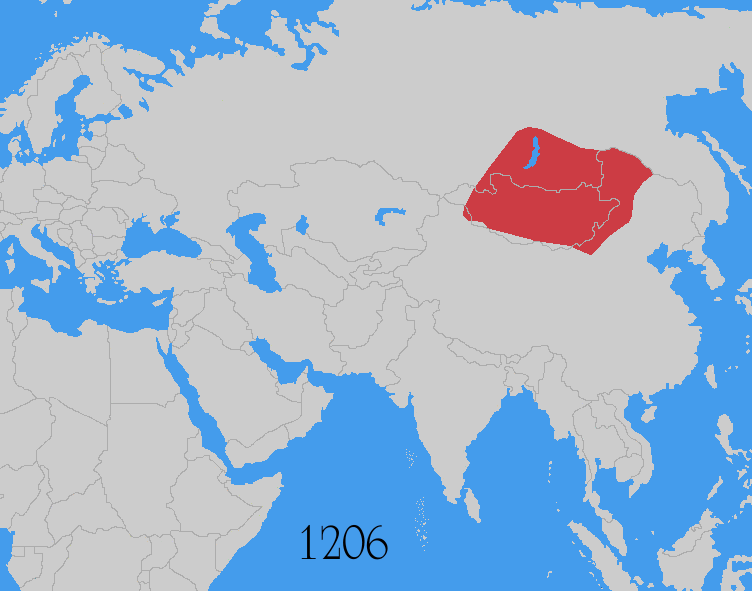
Map showing changes in borders of the Mongol Empire from founding by Genghis Khan in 1206, Genghis Khan's death in 1227 to the rule of Kublai Khan (1260–1294). (Uses modern day borders) Mongol Empire
By 1294 the empire had split into: Yuan Dynasty (Great Khanate) |
| ದಿನಾಂಕ | |
| ಆಕರ | Based on the freely licenced Image:Genghis khan empire at his death.png using information from maps of the Mongol Empire in atlases and on the web such as [1], [2], [3], [4], [5]. Made in Photoshop and Painter. |
| ಕರ್ತೃ | User:Astrokey44 |
| ಅನುಮತಿ (ಈ ಕಡತವನ್ನು ಮರುಬಳಕೆ ಮಾಡಲಾಗುತ್ತಿದೆ) |
self made |
| ಇತರೆ ಆವೃತ್ತಿಗಳು |
Derivative works of this file: Mongol Empire map 2.gif other maps on commons - same animation but with alternative colours, greatest extent, Mongol dominions, 1294 |
![[1]](http://www.silk-road.com/maps/images/mongol.jpg)
![[2]](http://www.loyno.edu/~seduffy/MapImages/MongolEmpire-display.jpg)
![[3]](http://www.siu.edu/~dfll/Chinese/mongol.jpg)
![[4]](http://www.allempires.com/empires/mongol/mongolempire_map.jpg)
![[5]](http://www.tiscali.co.uk/reference/encyclopaedia/hutchinson/images/c01786.jpg)
ಪರವಾನಗಿ
I, the copyright holder of this work, hereby publish it under the following licenses:

|
GNU ಉಚಿತ ಡಾಕ್ಯುಮೆಂಟೇಶನ್ ಪರವಾನಗಿ, ಆವೃತ್ತಿಯ ನಿಯಮಗಳ ಅಡಿಯಲ್ಲಿ ಈ ಡಾಕ್ಯುಮೆಂಟ್ ಅನ್ನು ನಕಲಿಸಲು, ವಿತರಿಸಲು ಮತ್ತು/ಅಥವಾ ಮಾರ್ಪಡಿಸಲು ಅನುಮತಿಯನ್ನು ನೀಡಲಾಗಿದೆ. 1.2 ಅಥವಾ ಯಾವುದೇ ನಂತರದ ಆವೃತ್ತಿಯನ್ನು ಉಚಿತ ಸಾಫ್ಟ್ವೇರ್ ಫೌಂಡೇಶನ್ ಪ್ರಕಟಿಸಿದೆ; ಯಾವುದೇ ಅಸ್ಥಿರ ವಿಭಾಗಗಳಿಲ್ಲದೆ, ಮುಖ ಪಠ್ಯಗಳಿಲ್ಲ ಮತ್ತು ಹಿಂದಿನ ಕವರ್ ಪಠ್ಯಗಳಿಲ್ಲ. ಪರವಾನಗಿಯ ಪ್ರತಿಯನ್ನು GNU ಉಚಿತ ಡಾಕ್ಯುಮೆಂಟೇಶನ್ ಪರವಾನಗಿ ಎಂಬ ವಿಭಾಗದಲ್ಲಿ ಸೇರಿಸಲಾಗಿದೆ. |
| ಈ ಕಡತ ಕ್ರಿಯೇಟಿವ್ ಕಾಮನ್ಸ್ Attribution -Share Alike 3.0 Unported ಪರವಾನಗಿ ಹೊಂದಿದೆ. | ||
| ||
| This licensing tag was added to this file as part of the GFDL licensing update. |
This file is licensed under the Creative Commons Attribution-Share Alike 2.5 Generic, 2.0 Generic and 1.0 Generic license.
- ನೀವು ಮುಕ್ತ:
- ಹಂಚಿಕೆಗೆ – ಕೆಲಸವನ್ನು ನಕಲು ಮಾಡಲು, ವಿತರಣೆ ಮತ್ತು ಸಾಗಿಸಲು
- ರೀಮಿಕ್ಸ್ ಮಾಡಲು – ಕೆಲಸವನ್ನು ಬಳಸಿಕೊಳ್ಳಲು
- ಈ ಕೆಳಗಿನ ಷರತ್ತುಗಳಲ್ಲಿ:
- ವೈಶಿಷ್ಟ್ಯ – ನೀವು ಸೂಕ್ತವಾದ ಕ್ರೆಡಿಟ್ ನೀಡಬೇಕು, ಪರವಾನಗಿಗೆ ಲಿಂಕ್ ಅನ್ನು ಒದಗಿಸಬೇಕು ಮತ್ತು ಯಾವುದೇ ಬದಲಾವಣೆಗಳನ್ನು ಮಾಡಿದ್ದರೆ ಸೂಚಿಸಬೇಕು. ನೀವು ಯಾವುದೇ ಸಮಂಜಸವಾದ ರೀತಿಯಲ್ಲಿ ಮಾಡಬಹುದು, ಆದರೆ ಪರವಾನಗಿದಾರರು ನಿಮ್ಮನ್ನು ಅಥವಾ ನಿಮ್ಮ ಯಾವುದೇ ಬಳಕೆಯನ್ನು ಅನುಮೋದಿಸಿದಂತೆ ರೀತಿಯಲ್ಲಿ ಉಪಯೋಗಿಸಬಾರದು.
- ಇರುವುದರಂತೆಯೇ ಹಂಚು – ನೀವು ರೀಮಿಕ್ಸ್ ಮಾಡಿದರೆ, ರೂಪಾಂತರಗೊಳಿಸಿದರೆ ಅಥವಾ ವಸ್ತುವಿನ ಮೇಲೆ ನಿರ್ಮಿಸಿದರೆ, ನಿಮ್ಮ ಕೊಡುಗೆಗಳನ್ನು ನೀವು ಮೂಲದಂತೆ ಅದೇ ಅಥವಾ ಹೊಂದಾಣಿಕೆಯ ಪರವಾನಗಿ ಅಡಿಯಲ್ಲಿ ವಿತರಿಸಬೇಕು.
ನಿಮ್ಮಿಚ್ಛೆಯ ಪರವಾನಗಿಯನ್ನು ನೀವು ಆರಿಸಿಕೊಳ್ಳಬಹುದು.
Additional sources
- For the Ilkhanate: Roolvink, R. (೨೦೦೭) Historical Atlas of the Muslim Peoples, Taylor and Francis, p. 26 ISBN: 9780415440943.
- Mongol dominions, 1226–1405: Shepherd, William Robert; C.S. Hammond & Company (೧೯೬೪) Historical atlas, Barnes & Noble, p. 92
- McKitterick, Rosamond (೨೦೦೩) Atlas of the medieval world, Oxford University Press, pp. 174–175 ISBN: 9780195221589.
| Annotations | This image is annotated: View the annotations at Commons |
ಕಡತದ ಇತಿಹಾಸ
ದಿನ/ಕಾಲ ಒತ್ತಿದರೆ ಆ ಸಮಯದಲ್ಲಿ ಈ ಕಡತದ ವಸ್ತುಸ್ಥಿತಿ ತೋರುತ್ತದೆ.
| ದಿನ/ಕಾಲ | ಕಿರುನೋಟ | ಆಯಾಮಗಳು | ಬಳಕೆದಾರ | ಟಿಪ್ಪಣಿ | |
|---|---|---|---|---|---|
| ಪ್ರಸಕ್ತ | ೧೨:೩೭, ೩೦ ಜುಲೈ ೨೦೧೪ | | ೭೫೨ × ೫೯೧ (೧೬೨ KB) | Sven Manguard | As per Commons:Overwriting existing files |
| ೧೨:೧೨, ೩೦ ಜುಲೈ ೨೦೧೪ |  | ೭೫೨ × ೫೯೧ (೫೯ KB) | Flamarial~commonswiki | Reverting evidence-lacking vandalism by User:Tm. | |
| ೧೨:೧೨, ೩೦ ಜುಲೈ ೨೦೧೪ |  | ೭೫೨ × ೫೯೧ (೫೯ KB) | Flamarial~commonswiki | Reverting evidence-lacking vandalism by User:Tm. | |
| ೧೧:೧೮, ೩೦ ಜುಲೈ ೨೦೧೪ |  | ೭೫೨ × ೫೯೧ (೧೬೨ KB) | Tm | Reverted to version as of 21:19, 29 July 2014 reverting persistant vandalism | |
| ೧೦:೪೭, ೩೦ ಜುಲೈ ೨೦೧೪ |  | ೭೫೨ × ೫೯೧ (೫೯ KB) | Flamarial~commonswiki | Reverting evidence-lacking vandalism by User:Tm. | |
| ೦೨:೪೯, ೩೦ ಜುಲೈ ೨೦೧೪ |  | ೭೫೨ × ೫೯೧ (೧೬೨ KB) | Tm | Reverted to version as of 06:51, 29 September 2009 reverting vandalism | |
| ೨೦:೨೪, ೨೯ ಜುಲೈ ೨೦೧೪ |  | ೭೫೨ × ೫೯೧ (೫೯ KB) | Flamarial~commonswiki | Previous version was historically inaccurate: Korea was not a part of the Mongol Empire. | |
| ೧೨:೨೧, ೨೯ ಸೆಪ್ಟೆಂಬರ್ ೨೦೦೯ |  | ೭೫೨ × ೫೯೧ (೧೬೨ KB) | Enerelt | Korea was part of the Empire. Rude vandalism abolished | |
| ೦೫:೩೫, ೨೬ ಸೆಪ್ಟೆಂಬರ್ ೨೦೦೯ |  | ೭೫೨ × ೫೯೧ (೫೯ KB) | Altaicmania | color was adjusted | |
| ೦೮:೧೨, ೬ ಆಗಸ್ಟ್ ೨೦೦೮ |  | ೭೫೨ × ೫೯೧ (೪೦ KB) | Historiographer~commonswiki | Reverted to version as of 23:06, 31 May 2008 |
ಕಡತ ಬಳಕೆ
ಈ ಕೆಳಗಿನ ಪುಟವು ಈ ಚಿತ್ರಕ್ಕೆ ಸಂಪರ್ಕ ಹೊಂದಿದೆ:
ಜಾಗತಿಕ ಕಡತ ಉಪಯೋಗ
ಈ ಕಡತವನ್ನು ಕೆಳಗಿನ ಬೇರೆ ವಿಕಿಗಳೂ ಉಪಯೋಗಿಸುತ್ತಿವೆ:
- ace.wikipedia.org ಮೇಲೆ ಬಳಕೆ
- af.wikipedia.org ಮೇಲೆ ಬಳಕೆ
- als.wikipedia.org ಮೇಲೆ ಬಳಕೆ
- am.wikipedia.org ಮೇಲೆ ಬಳಕೆ
- ar.wikipedia.org ಮೇಲೆ ಬಳಕೆ
- الدولة الإلخانية
- البصرة
- كربلاء
- بوابة:آسيا/مقالة مختارة
- تاريخ إيران
- إمبراطورية المغول
- ويكيبيديا:مقالة الصفحة الرئيسية المختارة/28
- بوابة:الإمبراطورية الروسية
- بوابة:الإمبراطورية الروسية/بوابات شقيقة
- النزاعات في آسيا
- بوابة:التاريخ/امبراطورية/1
- بوابة:التاريخ/فقرات منوعة/1
- بوابة:التاريخ/فقرات منوعة/أرشيف
- بوابة:الإمبراطورية الألمانية
- بوابة:الإمبراطورية الألمانية/بوابات شقيقة
- بوابة:إمبراطورية اليابان
- بوابة:إمبراطورية اليابان/بوابات شقيقة
- بوابة:الخلافة الراشدة
- بوابة:الدولة الأموية
- بوابة:الإمبراطورية الفرنسية الأولى/بوابات شقيقة
- بوابة:الإمبراطورية الفرنسية الأولى
- بوابة:الإمبراطورية النمساوية/بوابات شقيقة
- بوابة:الإمبراطورية النمساوية
- بوابة:الإمبراطورية البريطانية
- بوابة:الإمبراطورية البريطانية/بوابات شقيقة
- بوابة:الإمبراطورية الفرنسية الثانية
- بوابة:الإمبراطورية الفرنسية الثانية/بوابات شقيقة
- بوابة:الإمبراطورية البرتغالية
- بوابة:الإمبراطورية البرتغالية/بوابات شقيقة
- بوابة:الإمبراطورية النمساوية المجرية
- بوابة:الإمبراطورية النمساوية المجرية/بوابات شقيقة
- بوابة:الإمبراطورية المغولية
- بوابة:الإمبراطورية المغولية/واجهة
- بوابة:الإمبراطورية المغولية/بوابات شقيقة
- بوابة:الإمبراطورية الإسبانية
- بوابة:إمبراطوريات
- بوابة:إمبراطوريات/بوابات شقيقة
- بوابة:الإمبراطورية الإسبانية/بوابات شقيقة
- بوابة:العصور الوسطى/مقالة مختارة
- بوابة:العصور الوسطى/مقالة مختارة/4
- بوابة:الدولة الأموية/بوابات شقيقة
- بوابة:الخلافة الراشدة/بوابات شقيقة
- بوابة:آسيا/مقالة مختارة/أرشيف
- بوابة:آسيا/مقالة مختارة/6
- بوابة:مملكة فرنسا
ಈ ಫೈಲ್ನ ಹೆಚ್ಚು ಜಾಗತಿಕ ಬಳಕೆಯನ್ನು ವೀಕ್ಷಿಸಿ.