ಚಿತ್ರ:Matthew 2016-10-03 1315Z.png

ಈ ಮುನ್ನೋಟ ಗಾತ್ರ:೮೦೦ × ೪೫೦ ಪಿಕ್ಸೆಲ್ಗಳು. ಇತರ ರೆಸಲ್ಯೂಶನ್ಗಳು: ೩೨೦ × ೧೮೦ ಪಿಕ್ಸೆಲ್ಗಳು | ೬೪೦ × ೩೬೦ ಪಿಕ್ಸೆಲ್ಗಳು | ೧,೦೨೪ × ೫೭೬ ಪಿಕ್ಸೆಲ್ಗಳು | ೧,೨೮೦ × ೭೨೦ ಪಿಕ್ಸೆಲ್ಗಳು | ೨,೦೪೮ × ೧,೧೫೨ ಪಿಕ್ಸೆಲ್ಗಳು.
ಮೂಲ ಕಡತ (೨,೦೪೮ × ೧,೧೫೨ ಚಿತ್ರಬಿಂದು, ಫೈಲಿನ ಗಾತ್ರ: ೨.೮೬ MB, MIME ಪ್ರಕಾರ: image/png)
ಈ ಫೈಲು ವಿಕಿಮೀಡಿಯ ಕಾಮನ್ಸ್ನಲ್ಲಿ ಇರುವುದು. ಅಲ್ಲಿನ ವಿವರಣೆ ಪುಟವನ್ನೇ ಕೆಳಗೆ ತೋರಿಸಲಾಗಿದೆ. ಕಾಮನ್ಸ್ ಕೃತಿಸ್ವಾಮ್ಯತೆಯಿಂದ ಮುಕ್ತ ಫೈಲುಗಳ ಒಂದು ಆಗರ. ಅಲ್ಲಿ ನೀವೂ ಸಹಕರಿಸಬಹುದು. |
ಸಾರಾಂಶ
| ವಿವರ |
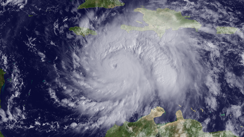
English: The GOES East satellite captured this image of Hurricane Matthew, currently located about 220 miles southeast of Kingston, Jamaica, at 1315 UTC on October 3, 2016. |
| ದಿನಾಂಕ | |
| ಆಕರ | https://www.nnvl.noaa.gov/MediaDetail2.php?MediaID=1935&MediaTypeID=1 |
| ಕರ್ತೃ | NOAA |
ಪರವಾನಗಿ
This image is in the public domain because it contains materials that originally came from the U.S. National Oceanic and Atmospheric Administration, taken or made as part of an employee's official duties.
|
ಕಡತದ ಇತಿಹಾಸ
ದಿನ/ಕಾಲ ಒತ್ತಿದರೆ ಆ ಸಮಯದಲ್ಲಿ ಈ ಕಡತದ ವಸ್ತುಸ್ಥಿತಿ ತೋರುತ್ತದೆ.
| ದಿನ/ಕಾಲ | ಕಿರುನೋಟ | ಆಯಾಮಗಳು | ಬಳಕೆದಾರ | ಟಿಪ್ಪಣಿ | |
|---|---|---|---|---|---|
| ಪ್ರಸಕ್ತ | ೧೪:೨೫, ೨೪ ಮಾರ್ಚ್ ೨೦೧೮ | | ೨,೦೪೮ × ೧,೧೫೨ (೨.೮೬ MB) | A1Cafel | User created page with UploadWizard |
ಕಡತ ಬಳಕೆ
ಈ ಕೆಳಗಿನ ಪುಟವು ಈ ಚಿತ್ರಕ್ಕೆ ಸಂಪರ್ಕ ಹೊಂದಿದೆ:
ಜಾಗತಿಕ ಕಡತ ಉಪಯೋಗ
ಈ ಕಡತವನ್ನು ಕೆಳಗಿನ ಬೇರೆ ವಿಕಿಗಳೂ ಉಪಯೋಗಿಸುತ್ತಿವೆ:
- de.wikipedia.org ಮೇಲೆ ಬಳಕೆ
- en.wikipedia.org ಮೇಲೆ ಬಳಕೆ
- mk.wikipedia.org ಮೇಲೆ ಬಳಕೆ
- ru.wikipedia.org ಮೇಲೆ ಬಳಕೆ
- uk.wikipedia.org ಮೇಲೆ ಬಳಕೆ