ಚಿತ್ರ:Map of current Interstates.svg

Size of this PNG preview of this SVG file: ೬೮೯ × ೪೩೨ ಪಿಕ್ಸೆಲ್ಗಳು. ಇತರ ರೆಸಲ್ಯೂಶನ್ಗಳು: ೩೨೦ × ೨೦೧ ಪಿಕ್ಸೆಲ್ಗಳು | ೬೪೦ × ೪೦೧ ಪಿಕ್ಸೆಲ್ಗಳು | ೧,೦೨೪ × ೬೪೨ ಪಿಕ್ಸೆಲ್ಗಳು | ೧,೨೮೦ × ೮೦೩ ಪಿಕ್ಸೆಲ್ಗಳು | ೨,೫೬೦ × ೧,೬೦೫ ಪಿಕ್ಸೆಲ್ಗಳು.
ಮೂಲ ಕಡತ (SVG ಫೈಲು, ಸುಮಾರಾಗಿ ೬೮೯ × ೪೩೨ ಚಿತ್ರಬಿಂದುಗಳು, ಫೈಲಿನ ಗಾತ್ರ: ೫೧೮ KB)
ಈ ಫೈಲು ವಿಕಿಮೀಡಿಯ ಕಾಮನ್ಸ್ನಲ್ಲಿ ಇರುವುದು. ಅಲ್ಲಿನ ವಿವರಣೆ ಪುಟವನ್ನೇ ಕೆಳಗೆ ತೋರಿಸಲಾಗಿದೆ. ಕಾಮನ್ಸ್ ಕೃತಿಸ್ವಾಮ್ಯತೆಯಿಂದ ಮುಕ್ತ ಫೈಲುಗಳ ಒಂದು ಆಗರ. ಅಲ್ಲಿ ನೀವೂ ಸಹಕರಿಸಬಹುದು. |

|
This file requires updating because: Multiple Interstates and future Interstate are Missing In doing so, you could add a timestamp to the file.
|
ಸಾರಾಂಶ
| ವಿವರ |
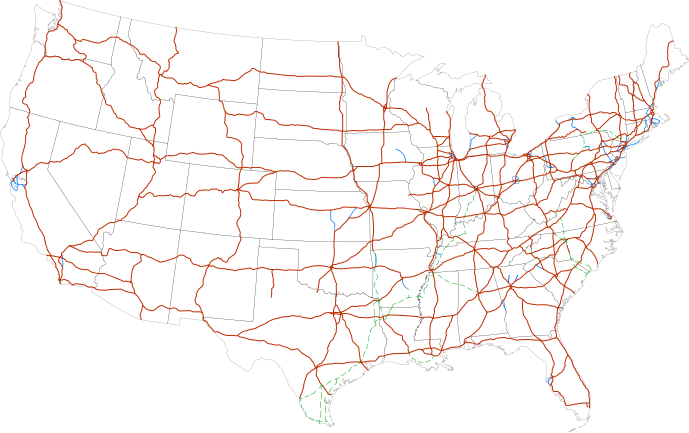
Labels:
One or Two-digit interstates (dark orange line)
Selected three-digit interstates (blue line)
Selected planned interstates (green dashed line) |
| ದಿನಾಂಕ | |
| ಆಕರ | National Atlas |
| ಕರ್ತೃ | SPUI |
ಪರವಾನಗಿ
| This work has been released into the public domain by its author, SPUI. This applies worldwide. In some countries this may not be legally possible; if so: |
| Annotations | This image is annotated: View the annotations at Commons |
ಕಡತದ ಇತಿಹಾಸ
ದಿನ/ಕಾಲ ಒತ್ತಿದರೆ ಆ ಸಮಯದಲ್ಲಿ ಈ ಕಡತದ ವಸ್ತುಸ್ಥಿತಿ ತೋರುತ್ತದೆ.
| ದಿನ/ಕಾಲ | ಕಿರುನೋಟ | ಆಯಾಮಗಳು | ಬಳಕೆದಾರ | ಟಿಪ್ಪಣಿ | |
|---|---|---|---|---|---|
| ಪ್ರಸಕ್ತ | ೧೬:೪೯, ೧೩ ಫೆಬ್ರವರಿ ೨೦೧೩ | | ೬೮೯ × ೪೩೨ (೫೧೮ KB) | Scott5114 | Add I-49 in Missouri |
| ೧೨:೦೯, ೧೧ ಜನವರಿ ೨೦೧೩ |  | ೬೮೯ × ೪೩೨ (೫೧೯ KB) | Agricolae | add I-376 rebranding north to I-80, planned I-99 from I-80 to I-86 | |
| ೧೨:೫೭, ೨ ಜುಲೈ ೨೦೧೧ |  | ೬೮೯ × ೪೩೨ (೪೮೫ KB) | Jkirkuslamont | Changed hues to improve legibility for the colour blind | |
| ೧೦:೦೬, ೧೦ ಜನವರಿ ೨೦೧೦ |  | ೬೮೯ × ೪೩೨ (೭೫೪ KB) | Techman224 | Made three-dight Interstates near Atlanta, Georgia blue | |
| ೦೩:೦೨, ೨೪ ಡಿಸೆಂಬರ್ ೨೦೦೯ |  | ೬೮೯ × ೪೩೨ (೭೫೪ KB) | Clorox | added I69 | |
| ೧೧:೪೨, ೨೯ ಫೆಬ್ರವರಿ ೨೦೦೮ |  | ೬೮೯ × ೪೩೨ (೭೪೪ KB) | Alex43223 | Updated a couple highways | |
| ೦೮:೦೮, ೨೨ ಜೂನ್ ೨೦೦೭ |  | ೬೮೯ × ೪೩೨ (೬೮೭ KB) | Fran Rogers | Reverted to earlier revision | |
| ೦೮:೦೭, ೨೨ ಜೂನ್ ೨೦೦೭ |  | ೬೮೯ × ೪೩೨ (೬೮೭ KB) | Fran Rogers | {{spuimap}} Map of the present Interstate Highway System. Base map is [http://www.nationalatlas.gov/printable/images/pdf/reference/genref.pdf] (public domain US Federal Government). *Purple: two-digit *Blue: selected three-digit *Green: selected future ro | |
| ೨೧:೩೭, ೧೩ ಜುಲೈ ೨೦೦೬ |  | ೬೮೯ × ೪೩೨ (೬೮೭ KB) | SPUI~commonswiki | {{spuimap}} |
ಕಡತ ಬಳಕೆ
ಈ ಕೆಳಗಿನ ಪುಟವು ಈ ಚಿತ್ರಕ್ಕೆ ಸಂಪರ್ಕ ಹೊಂದಿದೆ:
ಜಾಗತಿಕ ಕಡತ ಉಪಯೋಗ
ಈ ಕಡತವನ್ನು ಕೆಳಗಿನ ಬೇರೆ ವಿಕಿಗಳೂ ಉಪಯೋಗಿಸುತ್ತಿವೆ:
- an.wikipedia.org ಮೇಲೆ ಬಳಕೆ
- ar.wikipedia.org ಮೇಲೆ ಬಳಕೆ
- ast.wikipedia.org ಮೇಲೆ ಬಳಕೆ
- az.wikipedia.org ಮೇಲೆ ಬಳಕೆ
- bg.wikipedia.org ಮೇಲೆ ಬಳಕೆ
- bs.wikipedia.org ಮೇಲೆ ಬಳಕೆ
- ca.wikipedia.org ಮೇಲೆ ಬಳಕೆ
- da.wikipedia.org ಮೇಲೆ ಬಳಕೆ
- de.wikipedia.org ಮೇಲೆ ಬಳಕೆ
- en.wikipedia.org ಮೇಲೆ ಬಳಕೆ
- Economy of the United States
- Transportation in the United States
- List of gaps in Interstate Highways
- List of auxiliary Interstate Highways
- Controlled-access highway
- List of business routes of the Interstate Highway System
- User:Master son/US Roads
- User:Master son/US Roads/MTF
- Driving in the United States
- Trucking industry in the United States
- 1956 in the United States
- List of transport megaprojects
- User:Stephen100002/sandbox
- User:Vigneshdm1990/sandbox
- User:44Nifty/sandbox
- User:XanUltra
- Transportation policy of the United States
- Talk:United States/Archive 102
- Portal:Transport/Highway media
- Wikipedia talk:External links/Archive 42
- Wikipedia:Village pump (technical)/Archive 208
- en.wikibooks.org ಮೇಲೆ ಬಳಕೆ
- eo.wikipedia.org ಮೇಲೆ ಬಳಕೆ
- es.wikipedia.org ಮೇಲೆ ಬಳಕೆ
- et.wikipedia.org ಮೇಲೆ ಬಳಕೆ
- eu.wikipedia.org ಮೇಲೆ ಬಳಕೆ
- fa.wikipedia.org ಮೇಲೆ ಬಳಕೆ
- fi.wikipedia.org ಮೇಲೆ ಬಳಕೆ
ಈ ಫೈಲ್ನ ಹೆಚ್ಚು ಜಾಗತಿಕ ಬಳಕೆಯನ್ನು ವೀಕ್ಷಿಸಿ.