ಚಿತ್ರ:Java Topography.png

ಈ ಮುನ್ನೋಟ ಗಾತ್ರ:೮೦೦ × ೫೦೪ ಪಿಕ್ಸೆಲ್ಗಳು. ಇತರ ರೆಸಲ್ಯೂಶನ್ಗಳು: ೩೨೦ × ೨೦೨ ಪಿಕ್ಸೆಲ್ಗಳು | ೬೪೦ × ೪೦೩ ಪಿಕ್ಸೆಲ್ಗಳು | ೧,೦೨೪ × ೬೪೫ ಪಿಕ್ಸೆಲ್ಗಳು | ೧,೨೮೦ × ೮೦೬ ಪಿಕ್ಸೆಲ್ಗಳು | ೨,೬೮೮ × ೧,೬೯೩ ಪಿಕ್ಸೆಲ್ಗಳು.
ಮೂಲ ಕಡತ (೨,೬೮೮ × ೧,೬೯೩ ಚಿತ್ರಬಿಂದು, ಫೈಲಿನ ಗಾತ್ರ: ೧.೧೬ MB, MIME ಪ್ರಕಾರ: image/png)
ಈ ಫೈಲು ವಿಕಿಮೀಡಿಯ ಕಾಮನ್ಸ್ನಲ್ಲಿ ಇರುವುದು. ಅಲ್ಲಿನ ವಿವರಣೆ ಪುಟವನ್ನೇ ಕೆಳಗೆ ತೋರಿಸಲಾಗಿದೆ. ಕಾಮನ್ಸ್ ಕೃತಿಸ್ವಾಮ್ಯತೆಯಿಂದ ಮುಕ್ತ ಫೈಲುಗಳ ಒಂದು ಆಗರ. ಅಲ್ಲಿ ನೀವೂ ಸಹಕರಿಸಬಹುದು. |
ಸಾರಾಂಶ
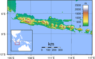
| ವಿವರ | Topography of Java. Created with GMT from publicly released SRTM data. For locator version, see Image:Java Locator Topography.png |
| ದಿನಾಂಕ | |
| ಆಕರ | ಸ್ವಂತ ಕೆಲಸ |
| ಕರ್ತೃ | Sadalmelik |
ಪರವಾನಗಿ
| I, the copyright holder of this work, release this work into the public domain. This applies worldwide. In some countries this may not be legally possible; if so: I grant anyone the right to use this work for any purpose, without any conditions, unless such conditions are required by law. |
ಕಡತದ ಇತಿಹಾಸ
ದಿನ/ಕಾಲ ಒತ್ತಿದರೆ ಆ ಸಮಯದಲ್ಲಿ ಈ ಕಡತದ ವಸ್ತುಸ್ಥಿತಿ ತೋರುತ್ತದೆ.
| ದಿನ/ಕಾಲ | ಕಿರುನೋಟ | ಆಯಾಮಗಳು | ಬಳಕೆದಾರ | ಟಿಪ್ಪಣಿ | |
|---|---|---|---|---|---|
| ಪ್ರಸಕ್ತ | ೦೦:೧೫, ೩೧ ಆಗಸ್ಟ್ ೨೦೦೭ | | ೨,೬೮೮ × ೧,೬೯೩ (೧.೧೬ MB) | Sadalmelik | {{Information |Description=Topography of Java. Created with GMT from publicly released SRTM data. |Source=self-made |Date=30 Aug, 2007 |Author= Sadalmelik }} Category:Maps of Indonesia Category:Topographic maps of Asia |
ಕಡತ ಬಳಕೆ
ಈ ಕೆಳಗಿನ ಪುಟವು ಈ ಚಿತ್ರಕ್ಕೆ ಸಂಪರ್ಕ ಹೊಂದಿದೆ:
ಜಾಗತಿಕ ಕಡತ ಉಪಯೋಗ
ಈ ಕಡತವನ್ನು ಕೆಳಗಿನ ಬೇರೆ ವಿಕಿಗಳೂ ಉಪಯೋಗಿಸುತ್ತಿವೆ:
- ace.wikipedia.org ಮೇಲೆ ಬಳಕೆ
- af.wikipedia.org ಮೇಲೆ ಬಳಕೆ
- az.wikipedia.org ಮೇಲೆ ಬಳಕೆ
- ban.wikipedia.org ಮೇಲೆ ಬಳಕೆ
- bbc.wikipedia.org ಮೇಲೆ ಬಳಕೆ
- bg.wikipedia.org ಮೇಲೆ ಬಳಕೆ
- bg.wikibooks.org ಮೇಲೆ ಬಳಕೆ
- bjn.wikipedia.org ಮೇಲೆ ಬಳಕೆ
- bo.wikipedia.org ಮೇಲೆ ಬಳಕೆ
- cs.wikipedia.org ಮೇಲೆ ಬಳಕೆ
- de.wikipedia.org ಮೇಲೆ ಬಳಕೆ
- el.wikipedia.org ಮೇಲೆ ಬಳಕೆ
- en.wikipedia.org ಮೇಲೆ ಬಳಕೆ
- en.wiktionary.org ಮೇಲೆ ಬಳಕೆ
- eo.wikipedia.org ಮೇಲೆ ಬಳಕೆ
- et.wikipedia.org ಮೇಲೆ ಬಳಕೆ
- fa.wikipedia.org ಮೇಲೆ ಬಳಕೆ
- frr.wikipedia.org ಮೇಲೆ ಬಳಕೆ
- fr.wikipedia.org ಮೇಲೆ ಬಳಕೆ
- fr.wikinews.org ಮೇಲೆ ಬಳಕೆ
- gl.wikipedia.org ಮೇಲೆ ಬಳಕೆ
- gor.wikipedia.org ಮೇಲೆ ಬಳಕೆ
- hak.wikipedia.org ಮೇಲೆ ಬಳಕೆ
- ha.wikipedia.org ಮೇಲೆ ಬಳಕೆ
- he.wikipedia.org ಮೇಲೆ ಬಳಕೆ
- id.wikipedia.org ಮೇಲೆ ಬಳಕೆ
- Jawa
- Candi Prambanan
- Bahasa Jawa Banyumasan
- Daftar kabupaten dan kota administrasi di Daerah Khusus Ibukota Jakarta
- Portal:Jawa
- Portal:Jawa/Intro
- Templat:Daftar portal/Indonesia
- Titik ekstrem Jawa
- Kategori:Wirausahawan Jawa
- Bahasa Jawa Indramayu
- Kategori:Sastrawan Jawa
- Garis besar Indonesia
- Kategori:Tokoh ekonomi Jawa
- Kategori:Tokoh seni budaya Jawa
- Kategori:Seniman Jawa
- Bahasa Jawa Pekalongan
- Story:Pulau Jawa
- Daftar kabupaten dan kota administrasi di Daerah Khusus Ibukota Jakarta berdasarkan waktu pembentukan
- id.wikibooks.org ಮೇಲೆ ಬಳಕೆ
- id.wiktionary.org ಮೇಲೆ ಬಳಕೆ
ಈ ಫೈಲ್ನ ಹೆಚ್ಚು ಜಾಗತಿಕ ಬಳಕೆಯನ್ನು ವೀಕ್ಷಿಸಿ.