ಚಿತ್ರ:Europe location SCO2.png

ಈ ಮುನ್ನೋಟ ಗಾತ್ರ:೮೦೦ × ೫೯೯ ಪಿಕ್ಸೆಲ್ಗಳು. ಇತರ ರೆಸಲ್ಯೂಶನ್ಗಳು: ೩೨೦ × ೨೪೦ ಪಿಕ್ಸೆಲ್ಗಳು | ೬೪೦ × ೪೭೯ ಪಿಕ್ಸೆಲ್ಗಳು | ೧,೦೨೪ × ೭೬೭ ಪಿಕ್ಸೆಲ್ಗಳು | ೧,೨೮೦ × ೯೫೯ ಪಿಕ್ಸೆಲ್ಗಳು | ೧,೫೯೪ × ೧,೧೯೪ ಪಿಕ್ಸೆಲ್ಗಳು.
ಮೂಲ ಕಡತ (೧,೫೯೪ × ೧,೧೯೪ ಚಿತ್ರಬಿಂದು, ಫೈಲಿನ ಗಾತ್ರ: ೫೫೮ KB, MIME ಪ್ರಕಾರ: image/png)
ಈ ಫೈಲು ವಿಕಿಮೀಡಿಯ ಕಾಮನ್ಸ್ನಲ್ಲಿ ಇರುವುದು. ಅಲ್ಲಿನ ವಿವರಣೆ ಪುಟವನ್ನೇ ಕೆಳಗೆ ತೋರಿಸಲಾಗಿದೆ. ಕಾಮನ್ಸ್ ಕೃತಿಸ್ವಾಮ್ಯತೆಯಿಂದ ಮುಕ್ತ ಫೈಲುಗಳ ಒಂದು ಆಗರ. ಅಲ್ಲಿ ನೀವೂ ಸಹಕರಿಸಬಹುದು. |
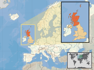
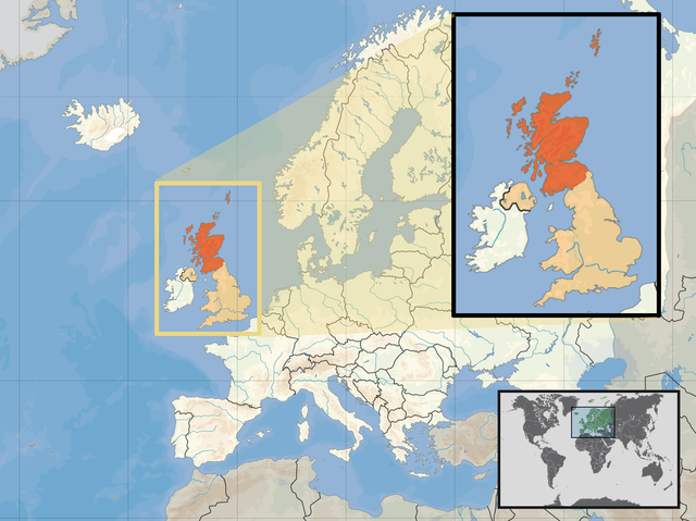
| ವಿವರ | Location of Scotland in the UK and Europe, on terrain map showing surface and underwater contour areas. | |||
| ದಿನಾಂಕ | ||||
| ಆಕರ | Derived from Wikimedia Commons image of original work forming part of the "Europe location" map series created by David Liuzzo: derived from Image:Europe_location_SCO.png. | |||
| ಕರ್ತೃ | uploaded by User:Kmusser (excerpt from User:David_Liuzzo) | |||
| ಅನುಮತಿ (ಈ ಕಡತವನ್ನು ಮರುಬಳಕೆ ಮಾಡಲಾಗುತ್ತಿದೆ) |
|
|||
| ಇತರೆ ಆವೃತ್ತಿಗಳು |
|


ಕಡತದ ಇತಿಹಾಸ
ದಿನ/ಕಾಲ ಒತ್ತಿದರೆ ಆ ಸಮಯದಲ್ಲಿ ಈ ಕಡತದ ವಸ್ತುಸ್ಥಿತಿ ತೋರುತ್ತದೆ.
| ದಿನ/ಕಾಲ | ಕಿರುನೋಟ | ಆಯಾಮಗಳು | ಬಳಕೆದಾರ | ಟಿಪ್ಪಣಿ | |
|---|---|---|---|---|---|
| ಪ್ರಸಕ್ತ | ೧೮:೦೯, ೧೦ ಏಪ್ರಿಲ್ ೨೦೧೭ | | ೧,೫೯೪ × ೧,೧೯೪ (೫೫೮ KB) | Von Sprat | Reverted to version as of 12:25, 27 May 2010 (UTC) |
| ೧೮:೦೯, ೧೦ ಏಪ್ರಿಲ್ ೨೦೧೭ |  | ೧,೬೦೦ × ೧,೨೦೦ (೭೮೮ KB) | Von Sprat | greece/turkey border | |
| ೧೭:೫೫, ೨೭ ಮೇ ೨೦೧೦ |  | ೧,೫೯೪ × ೧,೧೯೪ (೫೫೮ KB) | Ras67 | cropped | |
| ೨೩:೦೧, ೨೯ ಸೆಪ್ಟೆಂಬರ್ ೨೦೦೮ |  | ೧,೬೦೦ × ೧,೨೦೦ (೭೬೭ KB) | Kmusser | re-cropped inset to include Shetlands | |
| ೨೨:೫೨, ೨೯ ಸೆಪ್ಟೆಂಬರ್ ೨೦೦೮ |  | ೧,೬೦೦ × ೧,೨೦೦ (೮೦೭ KB) | Kmusser | {{Information |Description= Location of Scotland in the UK and Europe, on terrain map showing surface and underwater contour areas. |Source=Derived from Wikimedia Commons image of original work forming part of the "Europe location" map series |
ಕಡತ ಬಳಕೆ
ಈ ಕೆಳಗಿನ ಪುಟವು ಈ ಚಿತ್ರಕ್ಕೆ ಸಂಪರ್ಕ ಹೊಂದಿದೆ:
ಜಾಗತಿಕ ಕಡತ ಉಪಯೋಗ
ಈ ಕಡತವನ್ನು ಕೆಳಗಿನ ಬೇರೆ ವಿಕಿಗಳೂ ಉಪಯೋಗಿಸುತ್ತಿವೆ:
- als.wikipedia.org ಮೇಲೆ ಬಳಕೆ
- an.wikipedia.org ಮೇಲೆ ಬಳಕೆ
- az.wiktionary.org ಮೇಲೆ ಬಳಕೆ
- ca.wikipedia.org ಮೇಲೆ ಬಳಕೆ
- da.wikipedia.org ಮೇಲೆ ಬಳಕೆ
- en.wikipedia.org ಮೇಲೆ ಬಳಕೆ
- es.wikipedia.org ಮೇಲೆ ಬಳಕೆ
- eu.wiktionary.org ಮೇಲೆ ಬಳಕೆ
- ext.wikipedia.org ಮೇಲೆ ಬಳಕೆ
- fiu-vro.wikipedia.org ಮೇಲೆ ಬಳಕೆ
- fr.wikinews.org ಮೇಲೆ ಬಳಕೆ
- gag.wikipedia.org ಮೇಲೆ ಬಳಕೆ
- gl.wikipedia.org ಮೇಲೆ ಬಳಕೆ
- hr.wikipedia.org ಮೇಲೆ ಬಳಕೆ
- hr.wikiquote.org ಮೇಲೆ ಬಳಕೆ
- krc.wikipedia.org ಮೇಲೆ ಬಳಕೆ
- ml.wikipedia.org ಮೇಲೆ ಬಳಕೆ
- mnw.wikipedia.org ಮೇಲೆ ಬಳಕೆ
- mr.wikipedia.org ಮೇಲೆ ಬಳಕೆ
- my.wikipedia.org ಮೇಲೆ ಬಳಕೆ
- nov.wikipedia.org ಮೇಲೆ ಬಳಕೆ
- no.wikipedia.org ಮೇಲೆ ಬಳಕೆ
- pl.wikipedia.org ಮೇಲೆ ಬಳಕೆ
- pl.wikivoyage.org ಮೇಲೆ ಬಳಕೆ
- pl.wiktionary.org ಮೇಲೆ ಬಳಕೆ
- su.wikipedia.org ಮೇಲೆ ಬಳಕೆ
- sv.wikivoyage.org ಮೇಲೆ ಬಳಕೆ
- te.wikipedia.org ಮೇಲೆ ಬಳಕೆ
- tr.wikipedia.org ಮೇಲೆ ಬಳಕೆ
- ug.wikipedia.org ಮೇಲೆ ಬಳಕೆ
- vls.wikipedia.org ಮೇಲೆ ಬಳಕೆ
- yo.wikipedia.org ಮೇಲೆ ಬಳಕೆ