ಚಿತ್ರ:Cayman Islands Map.svg

Size of this PNG preview of this SVG file: ೫೦೨ × ೨೪೯ ಪಿಕ್ಸೆಲ್ಗಳು. ಇತರ ರೆಸಲ್ಯೂಶನ್ಗಳು: ೩೨೦ × ೧೫೯ ಪಿಕ್ಸೆಲ್ಗಳು | ೬೪೦ × ೩೧೭ ಪಿಕ್ಸೆಲ್ಗಳು | ೧,೦೨೪ × ೫೦೮ ಪಿಕ್ಸೆಲ್ಗಳು | ೧,೨೮೦ × ೬೩೫ ಪಿಕ್ಸೆಲ್ಗಳು | ೨,೫೬೦ × ೧,೨೭೦ ಪಿಕ್ಸೆಲ್ಗಳು.
ಮೂಲ ಕಡತ (SVG ಫೈಲು, ಸುಮಾರಾಗಿ ೫೦೨ × ೨೪೯ ಚಿತ್ರಬಿಂದುಗಳು, ಫೈಲಿನ ಗಾತ್ರ: ೧೫ KB)
ಈ ಫೈಲು ವಿಕಿಮೀಡಿಯ ಕಾಮನ್ಸ್ನಲ್ಲಿ ಇರುವುದು. ಅಲ್ಲಿನ ವಿವರಣೆ ಪುಟವನ್ನೇ ಕೆಳಗೆ ತೋರಿಸಲಾಗಿದೆ. ಕಾಮನ್ಸ್ ಕೃತಿಸ್ವಾಮ್ಯತೆಯಿಂದ ಮುಕ್ತ ಫೈಲುಗಳ ಒಂದು ಆಗರ. ಅಲ್ಲಿ ನೀವೂ ಸಹಕರಿಸಬಹುದು. |
ಸಾರಾಂಶ
| ವಿವರ |
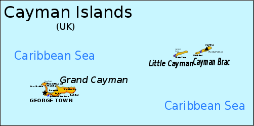
English: Map of the Cayman Islands. Information from CIA MAP, Yahoo Map, [1] Can be translated through version 1 here, although text must be converted to path due to rendering problems. |
| ದಿನಾಂಕ | original unknown |
| ಆಕರ | outline from PlaniGlobe |
| ಕರ್ತೃ | Planiglobe (outline), RaviC |
| ಇತರೆ ಆವೃತ್ತಿಗಳು |
Derivative works of this file: |
| SVG genesis |
![[1]](http://www.wordtravels.com/images/map/Cayman_Islands_map.jpg)
ಪರವಾನಗಿ
This file is licensed under the Creative Commons Attribution 2.5 Generic license.
- ನೀವು ಮುಕ್ತ:
- ಹಂಚಿಕೆಗೆ – ಕೆಲಸವನ್ನು ನಕಲು ಮಾಡಲು, ವಿತರಣೆ ಮತ್ತು ಸಾಗಿಸಲು
- ರೀಮಿಕ್ಸ್ ಮಾಡಲು – ಕೆಲಸವನ್ನು ಬಳಸಿಕೊಳ್ಳಲು
- ಈ ಕೆಳಗಿನ ಷರತ್ತುಗಳಲ್ಲಿ:
- ವೈಶಿಷ್ಟ್ಯ – ನೀವು ಸೂಕ್ತವಾದ ಕ್ರೆಡಿಟ್ ನೀಡಬೇಕು, ಪರವಾನಗಿಗೆ ಲಿಂಕ್ ಅನ್ನು ಒದಗಿಸಬೇಕು ಮತ್ತು ಯಾವುದೇ ಬದಲಾವಣೆಗಳನ್ನು ಮಾಡಿದ್ದರೆ ಸೂಚಿಸಬೇಕು. ನೀವು ಯಾವುದೇ ಸಮಂಜಸವಾದ ರೀತಿಯಲ್ಲಿ ಮಾಡಬಹುದು, ಆದರೆ ಪರವಾನಗಿದಾರರು ನಿಮ್ಮನ್ನು ಅಥವಾ ನಿಮ್ಮ ಯಾವುದೇ ಬಳಕೆಯನ್ನು ಅನುಮೋದಿಸಿದಂತೆ ರೀತಿಯಲ್ಲಿ ಉಪಯೋಗಿಸಬಾರದು.
ಕಡತದ ಇತಿಹಾಸ
ದಿನ/ಕಾಲ ಒತ್ತಿದರೆ ಆ ಸಮಯದಲ್ಲಿ ಈ ಕಡತದ ವಸ್ತುಸ್ಥಿತಿ ತೋರುತ್ತದೆ.
| ದಿನ/ಕಾಲ | ಕಿರುನೋಟ | ಆಯಾಮಗಳು | ಬಳಕೆದಾರ | ಟಿಪ್ಪಣಿ | |
|---|---|---|---|---|---|
| ಪ್ರಸಕ್ತ | ೦೪:೧೧, ೧೭ ನವೆಂಬರ್ ೨೦೧೮ | | ೫೦೨ × ೨೪೯ (೧೫ KB) | JoKalliauer | phab:T35245 real text again |
| ೨೧:೫೦, ೭ ಏಪ್ರಿಲ್ ೨೦೦೯ |  | ೫೦೨ × ೨೪೯ (೨೫೭ KB) | RaviC | added more information from http://www.wordtravels.com/images/map/Cayman_Islands_map.jpg | |
| ೦೨:೨೧, ೭ ಏಪ್ರಿಲ್ ೨೦೦೯ |  | ೫೦೨ × ೨೪೯ (೨೩೫ KB) | Pbrks | rendering problems | |
| ೦೦:೪೮, ೭ ಏಪ್ರಿಲ್ ೨೦೦೯ |  | ೫೦೨ × ೨೪೯ (೨೩ KB) | RaviC | {{Information |Description={{en|1=Map of the Cayman Islands.}} Information from [http://upload.wikimedia.org/wikipedia/commons/2/20/Cayman_Islands-CIA_WFB_Map.png CIA MAP], [http://www.mbs.maine.edu/~strong_robert/Cayman%20Islands%20trip/Cayman%20Islands% |
ಕಡತ ಬಳಕೆ
ಈ ಕೆಳಗಿನ ಪುಟವು ಈ ಚಿತ್ರಕ್ಕೆ ಸಂಪರ್ಕ ಹೊಂದಿದೆ:
ಜಾಗತಿಕ ಕಡತ ಉಪಯೋಗ
ಈ ಕಡತವನ್ನು ಕೆಳಗಿನ ಬೇರೆ ವಿಕಿಗಳೂ ಉಪಯೋಗಿಸುತ್ತಿವೆ:
- als.wikipedia.org ಮೇಲೆ ಬಳಕೆ
- ba.wikipedia.org ಮೇಲೆ ಬಳಕೆ
- bn.wikipedia.org ಮೇಲೆ ಬಳಕೆ
- br.wikipedia.org ಮೇಲೆ ಬಳಕೆ
- en.wikipedia.org ಮೇಲೆ ಬಳಕೆ
- Cayman Islands
- Geography of the Cayman Islands
- List of airports in the Cayman Islands
- Portal:Caribbean/Selected geography article
- Portal:Caribbean/Selected geography article/12
- Cyclura nubila caymanensis
- Outline of the Cayman Islands
- Index of Cayman Islands–related articles
- Wikipedia:Graphics Lab/Image workshop/Archive/Apr 2009
- Talk:British Isles/Archive 30
- es.wikipedia.org ಮೇಲೆ ಬಳಕೆ
- fa.wikipedia.org ಮೇಲೆ ಬಳಕೆ
- fi.wikipedia.org ಮೇಲೆ ಬಳಕೆ
- fr.wikipedia.org ಮೇಲೆ ಬಳಕೆ
- he.wikipedia.org ಮೇಲೆ ಬಳಕೆ
- id.wikipedia.org ಮೇಲೆ ಬಳಕೆ
- io.wikipedia.org ಮೇಲೆ ಬಳಕೆ
- it.wikipedia.org ಮೇಲೆ ಬಳಕೆ
- ja.wikipedia.org ಮೇಲೆ ಬಳಕೆ
- lb.wikipedia.org ಮೇಲೆ ಬಳಕೆ
- lt.wikipedia.org ಮೇಲೆ ಬಳಕೆ
- ml.wikipedia.org ಮೇಲೆ ಬಳಕೆ
- mrj.wikipedia.org ಮೇಲೆ ಬಳಕೆ
- nl.wikipedia.org ಮೇಲೆ ಬಳಕೆ
- no.wikipedia.org ಮೇಲೆ ಬಳಕೆ
- pcd.wikipedia.org ಮೇಲೆ ಬಳಕೆ
- pl.wikipedia.org ಮೇಲೆ ಬಳಕೆ
- pt.wikipedia.org ಮೇಲೆ ಬಳಕೆ
- ru.wikipedia.org ಮೇಲೆ ಬಳಕೆ
- sh.wikipedia.org ಮೇಲೆ ಬಳಕೆ
- sv.wikipedia.org ಮೇಲೆ ಬಳಕೆ
- tr.wikipedia.org ಮೇಲೆ ಬಳಕೆ
- tr.wiktionary.org ಮೇಲೆ ಬಳಕೆ
- tt.wikipedia.org ಮೇಲೆ ಬಳಕೆ
- uk.wikipedia.org ಮೇಲೆ ಬಳಕೆ
ಈ ಫೈಲ್ನ ಹೆಚ್ಚು ಜಾಗತಿಕ ಬಳಕೆಯನ್ನು ವೀಕ್ಷಿಸಿ.