ಚಿತ್ರ:Bombaymapconfirmed attacks.png

ಈ ಮುನ್ನೋಟ ಗಾತ್ರ:೫೭೭ × ೬೦೦ ಪಿಕ್ಸೆಲ್ಗಳು. ಇತರ ರೆಸಲ್ಯೂಶನ್ಗಳು: ೨೩೧ × ೨೪೦ ಪಿಕ್ಸೆಲ್ಗಳು | ೪೬೨ × ೪೮೦ ಪಿಕ್ಸೆಲ್ಗಳು | ೯೦೫ × ೯೪೧ ಪಿಕ್ಸೆಲ್ಗಳು.
ಮೂಲ ಕಡತ (೯೦೫ × ೯೪೧ ಚಿತ್ರಬಿಂದು, ಫೈಲಿನ ಗಾತ್ರ: ೨೨೨ KB, MIME ಪ್ರಕಾರ: image/png)
ಈ ಫೈಲು ವಿಕಿಮೀಡಿಯ ಕಾಮನ್ಸ್ನಲ್ಲಿ ಇರುವುದು. ಅಲ್ಲಿನ ವಿವರಣೆ ಪುಟವನ್ನೇ ಕೆಳಗೆ ತೋರಿಸಲಾಗಿದೆ. ಕಾಮನ್ಸ್ ಕೃತಿಸ್ವಾಮ್ಯತೆಯಿಂದ ಮುಕ್ತ ಫೈಲುಗಳ ಒಂದು ಆಗರ. ಅಲ್ಲಿ ನೀವೂ ಸಹಕರಿಸಬಹುದು. |
| ವಿವರ |
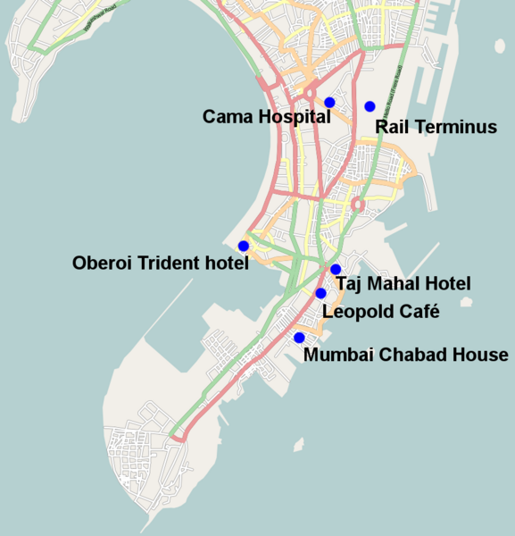
English: Map of the fairly solidly confirmed locations of the 26 November 2008 Mumbai attacks except Vile Parle suburb which is too vague and the port attack which again is still unclear also missing is the police station where it is unclear which one came under attack |
| ದಿನಾಂಕ | |
| ಆಕರ | open streetmaps with modifications http://www.openstreetmap.org/?lat=19.0072&lon=72.865&zoom=12&layers=B000FTFT |
| ಕರ್ತೃ | user:geni open street maps |
| ಅನುಮತಿ (ಈ ಕಡತವನ್ನು ಮರುಬಳಕೆ ಮಾಡಲಾಗುತ್ತಿದೆ) |
Creative Commons Attribution-ShareAlike 2.0 |
| ವಿವರ | Map of Mumbai. This map may be incomplete, and may contain errors. Don't rely solely on it for navigation. |
| ದಿನಾಂಕ | See file history |
| ಆಕರ | OpenStreetMap data |
| ಕರ್ತೃ | OpenStreetMap contributors |
| ಅನುಮತಿ (ಈ ಕಡತವನ್ನು ಮರುಬಳಕೆ ಮಾಡಲಾಗುತ್ತಿದೆ) |
All OpenStreetMap data and maps are Creative Commons "CC-BY-SA 2.0" licensed. This file is licensed under the Creative Commons Attribution-Share Alike 2.0 Generic license.
|
ಕಡತದ ಇತಿಹಾಸ
ದಿನ/ಕಾಲ ಒತ್ತಿದರೆ ಆ ಸಮಯದಲ್ಲಿ ಈ ಕಡತದ ವಸ್ತುಸ್ಥಿತಿ ತೋರುತ್ತದೆ.
| ದಿನ/ಕಾಲ | ಕಿರುನೋಟ | ಆಯಾಮಗಳು | ಬಳಕೆದಾರ | ಟಿಪ್ಪಣಿ | |
|---|---|---|---|---|---|
| ಪ್ರಸಕ್ತ | ೦೭:೪೩, ೨೮ ನವೆಂಬರ್ ೨೦೦೮ | | ೯೦೫ × ೯೪೧ (೨೨೨ KB) | Geni | {{Information |Description={{en|1=Map of the fairly solidly confimed locations of the 26 November 2008 Mumbai attacks except Vile Parle suburb which is too vague and the port attack which again is still unclear}} |Source=open streetmaps with modifications |
ಕಡತ ಬಳಕೆ
ಈ ಕೆಳಗಿನ 2 ಪುಟಗಳು ಈ ಚಿತ್ರಕ್ಕೆ ಸಂಪರ್ಕ ಹೊಂದಿವೆ:
ಜಾಗತಿಕ ಕಡತ ಉಪಯೋಗ
ಈ ಕಡತವನ್ನು ಕೆಳಗಿನ ಬೇರೆ ವಿಕಿಗಳೂ ಉಪಯೋಗಿಸುತ್ತಿವೆ:
- ar.wikipedia.org ಮೇಲೆ ಬಳಕೆ
- ckb.wikipedia.org ಮೇಲೆ ಬಳಕೆ
- da.wikipedia.org ಮೇಲೆ ಬಳಕೆ
- de.wikipedia.org ಮೇಲೆ ಬಳಕೆ
- en.wikipedia.org ಮೇಲೆ ಬಳಕೆ
- en.wikinews.org ಮೇಲೆ ಬಳಕೆ
- fa.wikipedia.org ಮೇಲೆ ಬಳಕೆ
- fy.wikipedia.org ಮೇಲೆ ಬಳಕೆ
- he.wikipedia.org ಮೇಲೆ ಬಳಕೆ
- hi.wikipedia.org ಮೇಲೆ ಬಳಕೆ
- ja.wikipedia.org ಮೇಲೆ ಬಳಕೆ
- li.wikipedia.org ಮೇಲೆ ಬಳಕೆ
- mai.wikipedia.org ಮೇಲೆ ಬಳಕೆ
- ml.wikipedia.org ಮೇಲೆ ಬಳಕೆ
- nl.wikipedia.org ಮೇಲೆ ಬಳಕೆ
- pa.wikipedia.org ಮೇಲೆ ಬಳಕೆ
- simple.wikipedia.org ಮೇಲೆ ಬಳಕೆ
- tr.wikipedia.org ಮೇಲೆ ಬಳಕೆ
- uk.wikipedia.org ಮೇಲೆ ಬಳಕೆ
- zh.wikinews.org ಮೇಲೆ ಬಳಕೆ