ಚಿತ್ರ:Americas independence map.PNG

ಈ ಮುನ್ನೋಟ ಗಾತ್ರ:೪೦೭ × ೬೦೦ ಪಿಕ್ಸೆಲ್ಗಳು. ಇತರ ರೆಸಲ್ಯೂಶನ್ಗಳು: ೧೬೩ × ೨೪೦ ಪಿಕ್ಸೆಲ್ಗಳು | ೩೨೬ × ೪೮೦ ಪಿಕ್ಸೆಲ್ಗಳು | ೮೬೨ × ೧,೨೭೦ ಪಿಕ್ಸೆಲ್ಗಳು.
ಮೂಲ ಕಡತ (೮೬೨ × ೧,೨೭೦ ಚಿತ್ರಬಿಂದು, ಫೈಲಿನ ಗಾತ್ರ: ೭೪ KB, MIME ಪ್ರಕಾರ: image/png)
ಈ ಫೈಲು ವಿಕಿಮೀಡಿಯ ಕಾಮನ್ಸ್ನಲ್ಲಿ ಇರುವುದು. ಅಲ್ಲಿನ ವಿವರಣೆ ಪುಟವನ್ನೇ ಕೆಳಗೆ ತೋರಿಸಲಾಗಿದೆ. ಕಾಮನ್ಸ್ ಕೃತಿಸ್ವಾಮ್ಯತೆಯಿಂದ ಮುಕ್ತ ಫೈಲುಗಳ ಒಂದು ಆಗರ. ಅಲ್ಲಿ ನೀವೂ ಸಹಕರಿಸಬಹುದು. |

|
This historical map image could be re-created using vector graphics as an SVG file. This has several advantages; see Commons:Media for cleanup for more information. If an SVG form of this image is available, please upload it and afterwards replace this template with
{{vector version available|new image name}}.
It is recommended to name the SVG file “Americas independence map.svg”—then the template Vector version available (or Vva) does not need the new image name parameter. |
ಸಾರಾಂಶ
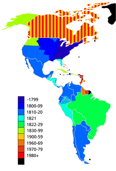
Map showing date of independence of country in the Americas. Black shows areas not yet independent.
Uses current boundaries, which may not correspond with the historical boundary of the country when it became independent. For example the United States was composed of 13 states on the East Coast when it became independent and did not reach its full continental extant until 1867 with the .
ಪರವಾನಗಿ

|
GNU ಉಚಿತ ಡಾಕ್ಯುಮೆಂಟೇಶನ್ ಪರವಾನಗಿ, ಆವೃತ್ತಿಯ ನಿಯಮಗಳ ಅಡಿಯಲ್ಲಿ ಈ ಡಾಕ್ಯುಮೆಂಟ್ ಅನ್ನು ನಕಲಿಸಲು, ವಿತರಿಸಲು ಮತ್ತು/ಅಥವಾ ಮಾರ್ಪಡಿಸಲು ಅನುಮತಿಯನ್ನು ನೀಡಲಾಗಿದೆ. 1.2 ಅಥವಾ ಯಾವುದೇ ನಂತರದ ಆವೃತ್ತಿಯನ್ನು ಉಚಿತ ಸಾಫ್ಟ್ವೇರ್ ಫೌಂಡೇಶನ್ ಪ್ರಕಟಿಸಿದೆ; ಯಾವುದೇ ಅಸ್ಥಿರ ವಿಭಾಗಗಳಿಲ್ಲದೆ, ಮುಖ ಪಠ್ಯಗಳಿಲ್ಲ ಮತ್ತು ಹಿಂದಿನ ಕವರ್ ಪಠ್ಯಗಳಿಲ್ಲ. ಪರವಾನಗಿಯ ಪ್ರತಿಯನ್ನು GNU ಉಚಿತ ಡಾಕ್ಯುಮೆಂಟೇಶನ್ ಪರವಾನಗಿ ಎಂಬ ವಿಭಾಗದಲ್ಲಿ ಸೇರಿಸಲಾಗಿದೆ. |
| ಈ ಕಡತ ಕ್ರಿಯೇಟಿವ್ ಕಾಮನ್ಸ್ Attribution -Share Alike 3.0 Unported ಪರವಾನಗಿ ಹೊಂದಿದೆ. | ||
| ||
| This licensing tag was added to this file as part of the GFDL licensing update. |
ಕಡತದ ಇತಿಹಾಸ
ದಿನ/ಕಾಲ ಒತ್ತಿದರೆ ಆ ಸಮಯದಲ್ಲಿ ಈ ಕಡತದ ವಸ್ತುಸ್ಥಿತಿ ತೋರುತ್ತದೆ.
| ದಿನ/ಕಾಲ | ಕಿರುನೋಟ | ಆಯಾಮಗಳು | ಬಳಕೆದಾರ | ಟಿಪ್ಪಣಿ | |
|---|---|---|---|---|---|
| ಪ್ರಸಕ್ತ | ೧೯:೫೩, ೧೧ ಮೇ ೨೦೧೯ | | ೮೬೨ × ೧,೨೭೦ (೭೪ KB) | Foghe | Removed Labrador border; only current international borders. |
| ೦೯:೦೨, ೨೫ ಏಪ್ರಿಲ್ ೨೦೧೯ |  | ೮೬೨ × ೧,೨೭೦ (೪೪ KB) | Marcomogollon | I add disputed territory between Colombia, Ecuador and Peru | |
| ೦೪:೪೧, ೪ ಅಕ್ಟೋಬರ್ ೨೦೧೧ |  | ೮೬೨ × ೧,೨೭೦ (೬೮ KB) | Lemonade100 | Added some current dependent territories and re-coded Canada - gained sovereignty in 1939 and full independence in 1982. | |
| ೦೦:೦೫, ೧೦ ನವೆಂಬರ್ ೨೦೧೦ |  | ೮೬೨ × ೧,೨೭೦ (೩೮ KB) | Minnecologies | Fixed error in northern Canada | |
| ೨೨:೫೫, ೯ ನವೆಂಬರ್ ೨೦೧೦ |  | ೮೬೨ × ೧,೨೭೦ (೩೮ KB) | Minnecologies | *Filled in Pacific Northwest *Added Saint Pierre and Miquelon *Updated the boundaries of Gran Colombia, Bolivia, and Peru *Changed color scheme to straight ROYGBIV | |
| ೧೨:೦೨, ೨೦ ಆಗಸ್ಟ್ ೨೦೦೭ |  | ೮೬೨ × ೧,೨೭೦ (೬೧ KB) | AlexCovarrubias | Mexico independence year is 1810 | |
| ೦೬:೧೮, ೭ ಡಿಸೆಂಬರ್ ೨೦೦೬ |  | ೮೬೨ × ೧,೨೭೦ (೪೯ KB) | Roke~commonswiki | include colonies | |
| ೧೮:೧೮, ೨೨ ಮಾರ್ಚ್ ೨೦೦೬ |  | ೮೬೨ × ೧,೨೭೦ (೬೩ KB) | Roke~commonswiki | Map showing date of independence of country in the Americas Category: America |
ಕಡತ ಬಳಕೆ
ಈ ಕೆಳಗಿನ ಪುಟವು ಈ ಚಿತ್ರಕ್ಕೆ ಸಂಪರ್ಕ ಹೊಂದಿದೆ:
ಜಾಗತಿಕ ಕಡತ ಉಪಯೋಗ
ಈ ಕಡತವನ್ನು ಕೆಳಗಿನ ಬೇರೆ ವಿಕಿಗಳೂ ಉಪಯೋಗಿಸುತ್ತಿವೆ:
- ar.wikipedia.org ಮೇಲೆ ಬಳಕೆ
- bg.wikipedia.org ಮೇಲೆ ಬಳಕೆ
- cs.wikipedia.org ಮೇಲೆ ಬಳಕೆ
- de.wikipedia.org ಮೇಲೆ ಬಳಕೆ
- en.wikipedia.org ಮೇಲೆ ಬಳಕೆ
- es.wikipedia.org ಮೇಲೆ ಬಳಕೆ
- fa.wikipedia.org ಮೇಲೆ ಬಳಕೆ
- fi.wikipedia.org ಮೇಲೆ ಬಳಕೆ
- fr.wikipedia.org ಮೇಲೆ ಬಳಕೆ
- fy.wikipedia.org ಮೇಲೆ ಬಳಕೆ
- gl.wikipedia.org ಮೇಲೆ ಬಳಕೆ
- ja.wikipedia.org ಮೇಲೆ ಬಳಕೆ
- ms.wikipedia.org ಮೇಲೆ ಬಳಕೆ
- nds-nl.wikipedia.org ಮೇಲೆ ಬಳಕೆ
- nl.wikipedia.org ಮೇಲೆ ಬಳಕೆ
- no.wikipedia.org ಮೇಲೆ ಬಳಕೆ
- pt.wikipedia.org ಮೇಲೆ ಬಳಕೆ
- sd.wikinews.org ಮೇಲೆ ಬಳಕೆ
- uk.wikipedia.org ಮೇಲೆ ಬಳಕೆ
- www.wikidata.org ಮೇಲೆ ಬಳಕೆ
- wo.wikipedia.org ಮೇಲೆ ಬಳಕೆ
- zh.wikipedia.org ಮೇಲೆ ಬಳಕೆ