ಚಿತ್ರ:Altai, Tienschan-Orte.png
ಇದಕ್ಕಿಂತ ಹೆಚ್ಚಿನ ವಿವರವಾದ ನೋಟ ಇಲ್ಲ.
Altai,_Tienschan-Orte.png (೬೬೦ × ೪೭೧ ಚಿತ್ರಬಿಂದು, ಫೈಲಿನ ಗಾತ್ರ: ೫೬೦ KB, MIME ಪ್ರಕಾರ: image/png)
ಈ ಫೈಲು ವಿಕಿಮೀಡಿಯ ಕಾಮನ್ಸ್ನಲ್ಲಿ ಇರುವುದು. ಅಲ್ಲಿನ ವಿವರಣೆ ಪುಟವನ್ನೇ ಕೆಳಗೆ ತೋರಿಸಲಾಗಿದೆ. ಕಾಮನ್ಸ್ ಕೃತಿಸ್ವಾಮ್ಯತೆಯಿಂದ ಮುಕ್ತ ಫೈಲುಗಳ ಒಂದು ಆಗರ. ಅಲ್ಲಿ ನೀವೂ ಸಹಕರಿಸಬಹುದು. |
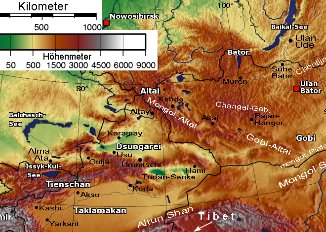
English: * Description: Relief Sattelite image Altay mountains and Tian Shan
- Beschreibung: Relief-Satellitenbild Altai-Gebirgsketten und Tienschan
- Quelle: [Bild:Mongolei-SinkiangTxt.png]
- nachbearbeitet 30.5.2005 von Benutzer:Geof (passender Ausschnitt, Maßstabsleiste, Orte etc.)
- Lizenz: gemeinfrei (public domain)
From de:Bild:Altai,Tienschan-Orte.png by de:Benutzer:Geof
Licence: PD-Self
| |
This work has been released into the public domain by its author, Geof, at the ಇಂಗ್ಲಿಷ್ ವಿಕಿಪೀಡಿಯ project. This applies worldwide. In case this is not legally possible: |
ಕಡತದ ಇತಿಹಾಸ
ದಿನ/ಕಾಲ ಒತ್ತಿದರೆ ಆ ಸಮಯದಲ್ಲಿ ಈ ಕಡತದ ವಸ್ತುಸ್ಥಿತಿ ತೋರುತ್ತದೆ.
| ದಿನ/ಕಾಲ | ಕಿರುನೋಟ | ಆಯಾಮಗಳು | ಬಳಕೆದಾರ | ಟಿಪ್ಪಣಿ | |
|---|---|---|---|---|---|
| ಪ್ರಸಕ್ತ | ೨೧:೦೬, ೨೬ ಮಾರ್ಚ್ ೨೦೦೬ | | ೬೬೦ × ೪೭೧ (೫೬೦ KB) | Hardscarf | * Description: Relief Sattelite image Altay mountains and Tian Shan * Beschreibung: Relief-Satellitenbild Altai-Gebirgsketten und Tienschan * Quelle: [Bild:Mongolei-SinkiangTxt.png] * nachbearbeitet 30.5.2005 von Benutzer:Geof (passender Ausschnitt, Maß |
ಕಡತ ಬಳಕೆ
ಈ ಕೆಳಗಿನ ಪುಟವು ಈ ಚಿತ್ರಕ್ಕೆ ಸಂಪರ್ಕ ಹೊಂದಿದೆ:
ಜಾಗತಿಕ ಕಡತ ಉಪಯೋಗ
ಈ ಕಡತವನ್ನು ಕೆಳಗಿನ ಬೇರೆ ವಿಕಿಗಳೂ ಉಪಯೋಗಿಸುತ್ತಿವೆ:
- af.wikipedia.org ಮೇಲೆ ಬಳಕೆ
- an.wikipedia.org ಮೇಲೆ ಬಳಕೆ
- ar.wikipedia.org ಮೇಲೆ ಬಳಕೆ
- arz.wikipedia.org ಮೇಲೆ ಬಳಕೆ
- ast.wikipedia.org ಮೇಲೆ ಬಳಕೆ
- be-tarask.wikipedia.org ಮೇಲೆ ಬಳಕೆ
- be.wikipedia.org ಮೇಲೆ ಬಳಕೆ
- bn.wikipedia.org ಮೇಲೆ ಬಳಕೆ
- bs.wikipedia.org ಮೇಲೆ ಬಳಕೆ
- ca.wikipedia.org ಮೇಲೆ ಬಳಕೆ
- ceb.wikipedia.org ಮೇಲೆ ಬಳಕೆ
- cs.wikipedia.org ಮೇಲೆ ಬಳಕೆ
- cy.wikipedia.org ಮೇಲೆ ಬಳಕೆ
- da.wikipedia.org ಮೇಲೆ ಬಳಕೆ
- de.wikipedia.org ಮೇಲೆ ಬಳಕೆ
- el.wikipedia.org ಮೇಲೆ ಬಳಕೆ
- en.wikipedia.org ಮೇಲೆ ಬಳಕೆ
- Tarim Basin
- Dzungaria
- Talk:History of the administrative divisions of China before 1912
- Altyn-Tagh
- User:Mattisse/Work
- Dzungarian Gate
- South Central Siberia
- Xinjiang
- User:Dzung01
- Altishahr
- Dzungar conquest of Altishahr
- Wikipedia:Graphics Lab/Map workshop/Archive/Dec 2015
- User:Hidayetullah/sandbox
- Talk:History of Xinjiang/Archive 1
- eo.wikipedia.org ಮೇಲೆ ಬಳಕೆ
- es.wikipedia.org ಮೇಲೆ ಬಳಕೆ
ಈ ಫೈಲ್ನ ಹೆಚ್ಚು ಜಾಗತಿಕ ಬಳಕೆಯನ್ನು ವೀಕ್ಷಿಸಿ.