ಚಿತ್ರ:Wimbledon map.jpg
ಈ ಮುನ್ನೋಟ ಗಾತ್ರ:೫೧೪ × ೫೯೯ ಪಿಕ್ಸೆಲ್ಗಳು. ಇತರ ರೆಸಲ್ಯೂಶನ್ಗಳು: ೨೦೬ × ೨೪೦ ಪಿಕ್ಸೆಲ್ಗಳು | ೪೧೨ × ೪೮೦ ಪಿಕ್ಸೆಲ್ಗಳು | ೬೫೯ × ೭೬೮ ಪಿಕ್ಸೆಲ್ಗಳು | ೮೭೯ × ೧,೦೨೪ ಪಿಕ್ಸೆಲ್ಗಳು | ೨,೨೧೮ × ೨,೫೮೫ ಪಿಕ್ಸೆಲ್ಗಳು.
ಮೂಲ ಕಡತ (೨,೨೧೮ × ೨,೫೮೫ ಚಿತ್ರಬಿಂದು, ಫೈಲಿನ ಗಾತ್ರ: ೪.೬ MB, MIME ಪ್ರಕಾರ: image/jpeg)
ಈ ಫೈಲು ವಿಕಿಮೀಡಿಯ ಕಾಮನ್ಸ್ನಲ್ಲಿ ಇರುವುದು. ಅಲ್ಲಿನ ವಿವರಣೆ ಪುಟವನ್ನೇ ಕೆಳಗೆ ತೋರಿಸಲಾಗಿದೆ. ಕಾಮನ್ಸ್ ಕೃತಿಸ್ವಾಮ್ಯತೆಯಿಂದ ಮುಕ್ತ ಫೈಲುಗಳ ಒಂದು ಆಗರ. ಅಲ್ಲಿ ನೀವೂ ಸಹಕರಿಸಬಹುದು. |
ಸಾರಾಂಶ
| ವಿವರ |
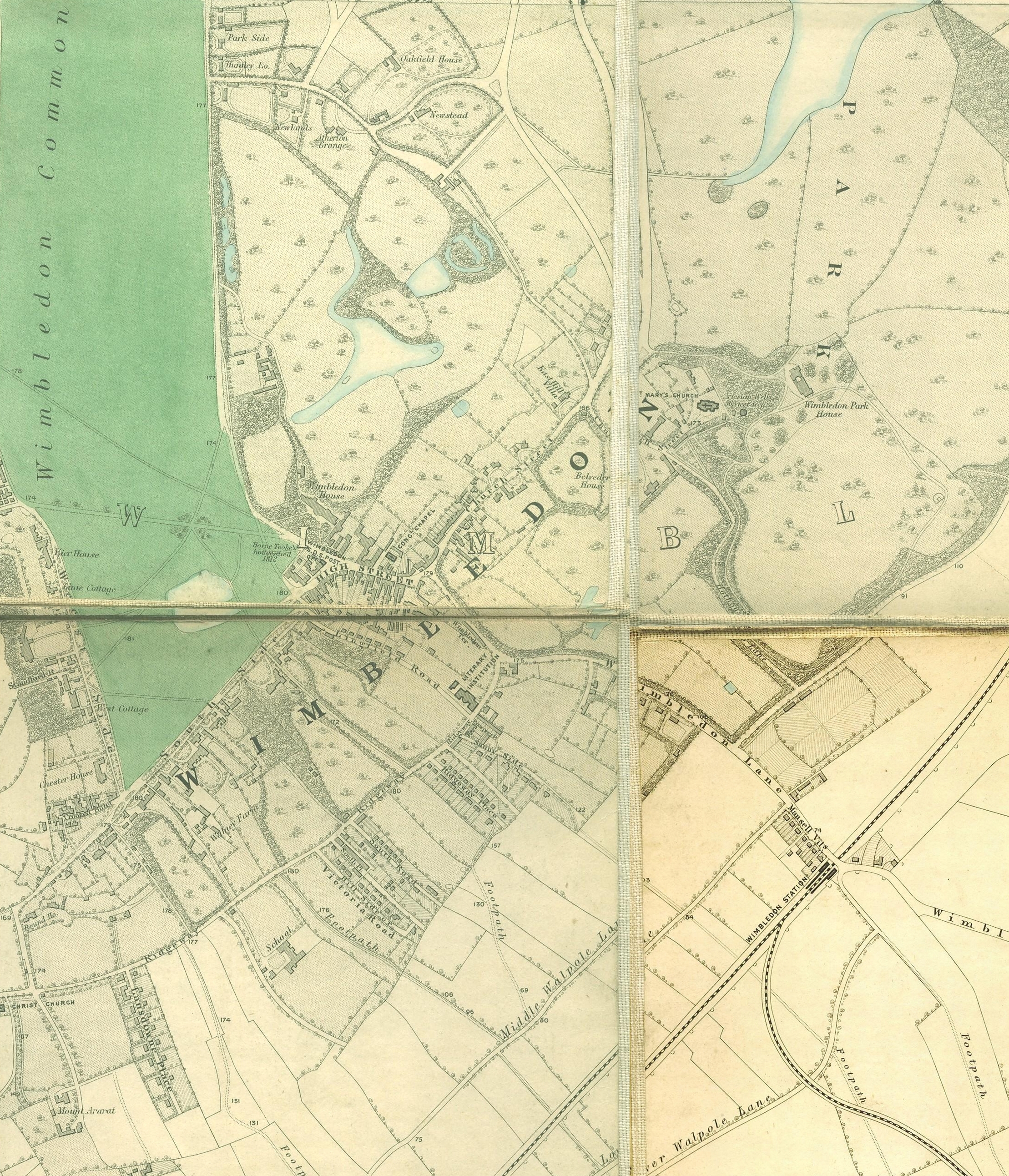
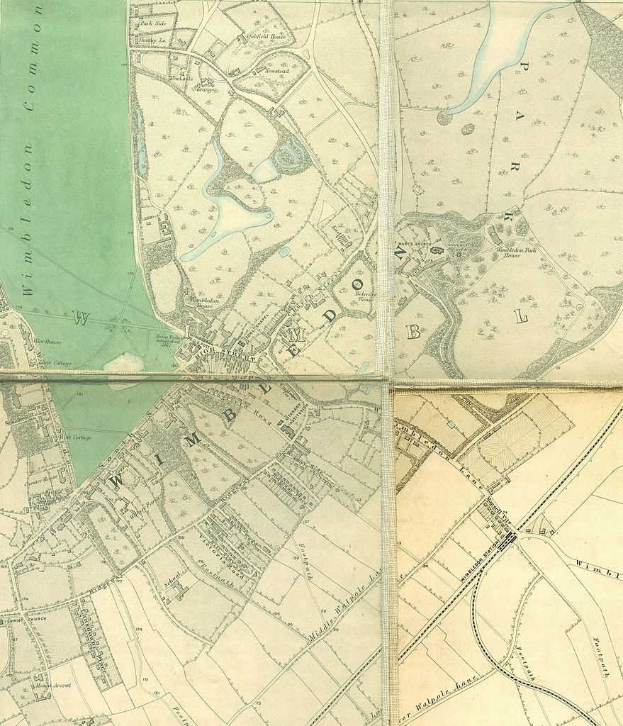
English: Wimbledon section of Edward Stanford's map of London, 1862 - 1871 |
|||||||||||||||||||
| ದಿನಾಂಕ | ೧೮೬೨ - ೧೮೭೧ | |||||||||||||||||||
| ಆಕರ | http://www.mappalondon.com/london/south-west/maps.htm | |||||||||||||||||||
| ಕರ್ತೃ |
|
|||||||||||||||||||
ಪರವಾನಗಿ
|
This work is in the public domain in its country of origin and other countries and areas where the copyright term is the author's life plus 100 years or fewer. | |
| This file has been identified as being free of known restrictions under copyright law, including all related and neighboring rights. | |
ಕಡತದ ಇತಿಹಾಸ
ದಿನ/ಕಾಲ ಒತ್ತಿದರೆ ಆ ಸಮಯದಲ್ಲಿ ಈ ಕಡತದ ವಸ್ತುಸ್ಥಿತಿ ತೋರುತ್ತದೆ.
| ದಿನ/ಕಾಲ | ಕಿರುನೋಟ | ಆಯಾಮಗಳು | ಬಳಕೆದಾರ | ಟಿಪ್ಪಣಿ | |
|---|---|---|---|---|---|
| ಪ್ರಸಕ್ತ | ೦೦:೧೨, ೧೫ ಜನವರಿ ೨೦೧೧ | | ೨,೨೧೮ × ೨,೫೮೫ (೪.೬ MB) | SilkTork | {{Information |Description={{en|1=Wimbledon section of Edward Stanford's map of London, 1862 - 1871 }} |Source=http://www.mappalondon.com/london/south-west/maps.htm |Author=Edward Stanford (died 1904) |Date=18 |
ಕಡತ ಬಳಕೆ
ಈ ಕೆಳಗಿನ ಪುಟವು ಈ ಚಿತ್ರಕ್ಕೆ ಸಂಪರ್ಕ ಹೊಂದಿದೆ:
ಜಾಗತಿಕ ಕಡತ ಉಪಯೋಗ
ಈ ಕಡತವನ್ನು ಕೆಳಗಿನ ಬೇರೆ ವಿಕಿಗಳೂ ಉಪಯೋಗಿಸುತ್ತಿವೆ:
- en.wikipedia.org ಮೇಲೆ ಬಳಕೆ
- hi.wikipedia.org ಮೇಲೆ ಬಳಕೆ