ಚಿತ್ರ:Geostationaryjava3D.gif
ಇದಕ್ಕಿಂತ ಹೆಚ್ಚಿನ ವಿವರವಾದ ನೋಟ ಇಲ್ಲ.
Geostationaryjava3D.gif (೨೨೦ × ೨೨೦ ಚಿತ್ರಬಿಂದು, ಫೈಲಿನ ಗಾತ್ರ: ೨೨೭ KB, MIME ಪ್ರಕಾರ: image/gif, ಲೂಪ್, ೧೮೩ frames, ೧೪ s)
ಈ ಫೈಲು ವಿಕಿಮೀಡಿಯ ಕಾಮನ್ಸ್ನಲ್ಲಿ ಇರುವುದು. ಅಲ್ಲಿನ ವಿವರಣೆ ಪುಟವನ್ನೇ ಕೆಳಗೆ ತೋರಿಸಲಾಗಿದೆ. ಕಾಮನ್ಸ್ ಕೃತಿಸ್ವಾಮ್ಯತೆಯಿಂದ ಮುಕ್ತ ಫೈಲುಗಳ ಒಂದು ಆಗರ. ಅಲ್ಲಿ ನೀವೂ ಸಹಕರಿಸಬಹುದು. |
ಸಾರಾಂಶ
| ವಿವರ |
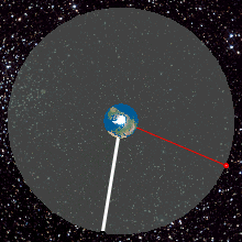
English: Top View of Geostationary orbit. To an observer on the rotating Earth (Africa on the Earth ), the satellite appears stationary in the sky as shown by the yellow radius. A red satellite is also geostationary above its own point on the Earth (Singapore)
http://weelookang.blogspot.com/2010/07/ejs-open-source-geostationary-satellite.html |
| ದಿನಾಂಕ | |
| ಆಕರ | ಸ್ವಂತ ಕೆಲಸ |
| ಕರ್ತೃ | Lookang many thanks to author of original simulation = Francisco Esquembre author of Easy Java Simulation = Francisco Esquembre |
ಪರವಾನಗಿ
I, the copyright holder of this work, hereby publish it under the following license:
ಈ ಕಡತ ಕ್ರಿಯೇಟಿವ್ ಕಾಮನ್ಸ್ Attribution
-Share Alike 3.0 Unported ಪರವಾನಗಿ ಹೊಂದಿದೆ.
- ನೀವು ಮುಕ್ತ:
- ಹಂಚಿಕೆಗೆ – ಕೆಲಸವನ್ನು ನಕಲು ಮಾಡಲು, ವಿತರಣೆ ಮತ್ತು ಸಾಗಿಸಲು
- ರೀಮಿಕ್ಸ್ ಮಾಡಲು – ಕೆಲಸವನ್ನು ಬಳಸಿಕೊಳ್ಳಲು
- ಈ ಕೆಳಗಿನ ಷರತ್ತುಗಳಲ್ಲಿ:
- ವೈಶಿಷ್ಟ್ಯ – ನೀವು ಸೂಕ್ತವಾದ ಕ್ರೆಡಿಟ್ ನೀಡಬೇಕು, ಪರವಾನಗಿಗೆ ಲಿಂಕ್ ಅನ್ನು ಒದಗಿಸಬೇಕು ಮತ್ತು ಯಾವುದೇ ಬದಲಾವಣೆಗಳನ್ನು ಮಾಡಿದ್ದರೆ ಸೂಚಿಸಬೇಕು. ನೀವು ಯಾವುದೇ ಸಮಂಜಸವಾದ ರೀತಿಯಲ್ಲಿ ಮಾಡಬಹುದು, ಆದರೆ ಪರವಾನಗಿದಾರರು ನಿಮ್ಮನ್ನು ಅಥವಾ ನಿಮ್ಮ ಯಾವುದೇ ಬಳಕೆಯನ್ನು ಅನುಮೋದಿಸಿದಂತೆ ರೀತಿಯಲ್ಲಿ ಉಪಯೋಗಿಸಬಾರದು.
- ಇರುವುದರಂತೆಯೇ ಹಂಚು – ನೀವು ರೀಮಿಕ್ಸ್ ಮಾಡಿದರೆ, ರೂಪಾಂತರಗೊಳಿಸಿದರೆ ಅಥವಾ ವಸ್ತುವಿನ ಮೇಲೆ ನಿರ್ಮಿಸಿದರೆ, ನಿಮ್ಮ ಕೊಡುಗೆಗಳನ್ನು ನೀವು ಮೂಲದಂತೆ ಅದೇ ಅಥವಾ ಹೊಂದಾಣಿಕೆಯ ಪರವಾನಗಿ ಅಡಿಯಲ್ಲಿ ವಿತರಿಸಬೇಕು.
ಕಡತದ ಇತಿಹಾಸ
ದಿನ/ಕಾಲ ಒತ್ತಿದರೆ ಆ ಸಮಯದಲ್ಲಿ ಈ ಕಡತದ ವಸ್ತುಸ್ಥಿತಿ ತೋರುತ್ತದೆ.
| ದಿನ/ಕಾಲ | ಕಿರುನೋಟ | ಆಯಾಮಗಳು | ಬಳಕೆದಾರ | ಟಿಪ್ಪಣಿ | |
|---|---|---|---|---|---|
| ಪ್ರಸಕ್ತ | ೦೮:೧೫, ೧೨ ಜೂನ್ ೨೦೧೩ | | ೨೨೦ × ೨೨೦ (೨೨೭ KB) | Lookang | updated to 2013 version |
| ೦೬:೫೨, ೨೭ ಜೂನ್ ೨೦೧೧ |  | ೨೨೦ × ೨೨೦ (೪೮೦ KB) | Lookang | Geostationary orbit.To an observer on the rotating Earth (fixed point on the Earth), the satellite appears stationary in the sky. A red satellite is also geostationary above its own point on Earth. Top Down View | |
| ೦೬:೪೪, ೨೭ ಜೂನ್ ೨೦೧೧ |  | ೨೮೦ × ೨೮೦ (೬೭೭ KB) | Lookang | trying to make the thumbnail animated by using comtasia 7 | |
| ೦೬:೩೮, ೨೭ ಜೂನ್ ೨೦೧೧ |  | ೨೮೦ × ೨೮೦ (೬೨೪ KB) | Lookang | Geostationary orbit.To an observer on the rotating Earth (fixed point on the Earth), the satellite appears stationary in the sky. A red satellite is also geostationary above its own point on Earth. Top Down View | |
| ೦೬:೩೬, ೨೭ ಜೂನ್ ೨೦೧೧ |  | ೩೦೦ × ೩೦೦ (೬೨೫ KB) | Lookang | Geostationary orbit.To an observer on the rotating Earth (fixed point on the Earth), the satellite appears stationary in the sky. A red satellite is also geostationary above its own point on Earth. Top Down View. | |
| ೦೬:೨೭, ೨೭ ಜೂನ್ ೨೦೧೧ |  | ೩೦೦ × ೩೦೦ (೬೫೩ KB) | Lookang |
ಕಡತ ಬಳಕೆ
ಈ ಕೆಳಗಿನ ಪುಟವು ಈ ಚಿತ್ರಕ್ಕೆ ಸಂಪರ್ಕ ಹೊಂದಿದೆ:
ಜಾಗತಿಕ ಕಡತ ಉಪಯೋಗ
ಈ ಕಡತವನ್ನು ಕೆಳಗಿನ ಬೇರೆ ವಿಕಿಗಳೂ ಉಪಯೋಗಿಸುತ್ತಿವೆ:
- af.wikipedia.org ಮೇಲೆ ಬಳಕೆ
- an.wikipedia.org ಮೇಲೆ ಬಳಕೆ
- ar.wikipedia.org ಮೇಲೆ ಬಳಕೆ
- ast.wikipedia.org ಮೇಲೆ ಬಳಕೆ
- bn.wikipedia.org ಮೇಲೆ ಬಳಕೆ
- bs.wikipedia.org ಮೇಲೆ ಬಳಕೆ
- ca.wikipedia.org ಮೇಲೆ ಬಳಕೆ
- en.wikipedia.org ಮೇಲೆ ಬಳಕೆ
- es.wikipedia.org ಮೇಲೆ ಬಳಕೆ
- et.wikipedia.org ಮೇಲೆ ಬಳಕೆ
- fa.wikipedia.org ಮೇಲೆ ಬಳಕೆ
- gl.wikipedia.org ಮೇಲೆ ಬಳಕೆ
- he.wikipedia.org ಮೇಲೆ ಬಳಕೆ
- hi.wikipedia.org ಮೇಲೆ ಬಳಕೆ
- hr.wikipedia.org ಮೇಲೆ ಬಳಕೆ
- hu.wikipedia.org ಮೇಲೆ ಬಳಕೆ
- hy.wikipedia.org ಮೇಲೆ ಬಳಕೆ
- io.wikipedia.org ಮೇಲೆ ಬಳಕೆ
- ml.wikipedia.org ಮೇಲೆ ಬಳಕೆ
- ms.wikipedia.org ಮೇಲೆ ಬಳಕೆ
- pl.wikipedia.org ಮೇಲೆ ಬಳಕೆ
- pnb.wikipedia.org ಮೇಲೆ ಬಳಕೆ
- pt.wikipedia.org ಮೇಲೆ ಬಳಕೆ
- ru.wikipedia.org ಮೇಲೆ ಬಳಕೆ
- ru.wikinews.org ಮೇಲೆ ಬಳಕೆ
- simple.wikipedia.org ಮೇಲೆ ಬಳಕೆ
- si.wikipedia.org ಮೇಲೆ ಬಳಕೆ
- sl.wikipedia.org ಮೇಲೆ ಬಳಕೆ
- sr.wikipedia.org ಮೇಲೆ ಬಳಕೆ
- ta.wikipedia.org ಮೇಲೆ ಬಳಕೆ
- te.wikipedia.org ಮೇಲೆ ಬಳಕೆ
- tg.wikipedia.org ಮೇಲೆ ಬಳಕೆ
- th.wikipedia.org ಮೇಲೆ ಬಳಕೆ
- ur.wikipedia.org ಮೇಲೆ ಬಳಕೆ
- vi.wikipedia.org ಮೇಲೆ ಬಳಕೆ
- www.wikidata.org ಮೇಲೆ ಬಳಕೆ
- zh-yue.wikipedia.org ಮೇಲೆ ಬಳಕೆ
- zh.wikipedia.org ಮೇಲೆ ಬಳಕೆ